Parade hike over the Risco Steig to Teno Alto
Today’s hike along the famous Risco Steig is a „must“ for every hiking enthusiast on Tenerife. Buenavista del Norte is located in the north of the island. And from there the Risco Climb leads steeply up to the craggy rock walls of the Teno.
Map
Close to Teno Alto - finca, fields, impressing landscape
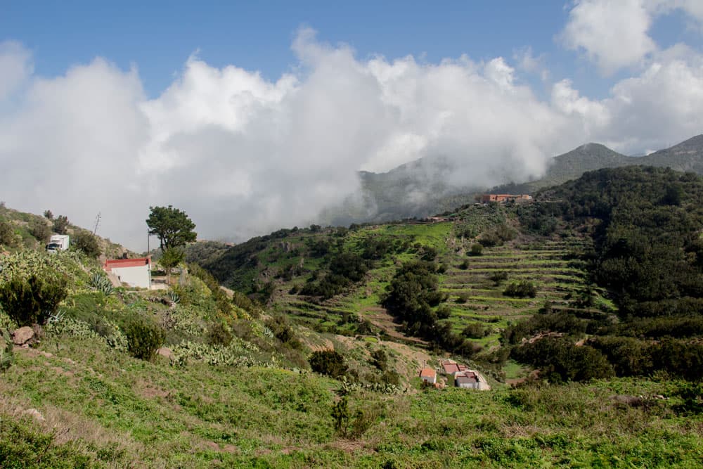
Once at the top, the circular hike continues across the plateau through green meadows and fields to the small village of Teno Alto. After a rest in the hamlet, the trail slowly descends towards the coast. If you like, you can visit the most northwestern point of Tenerife, the Punta de Teno with its lighthouse. Afterwards, we return to the starting point on the quiet coastal road with wonderful views of the rocks and the sea.

Road between Buenavista del Norte and Teno Altoprotected with nets against stone falls
Risco Steig – danger of falling rocks banished on the coastal road TF-445
The journey to the starting point for the hike on the Risco Steig is possible without problems. But if you want to continue to Punta de Teno by car, you can only do so from Thursday to Sunday before 10.00 am and after 17.00 pm. In the remaining time on the road from Thursday to Sunday only buses, taxis and authorized vehicles are permitted. Cyclists and pedestrians can use the road at any time. This regulatory measure is intended to protect the area from too much traffic.
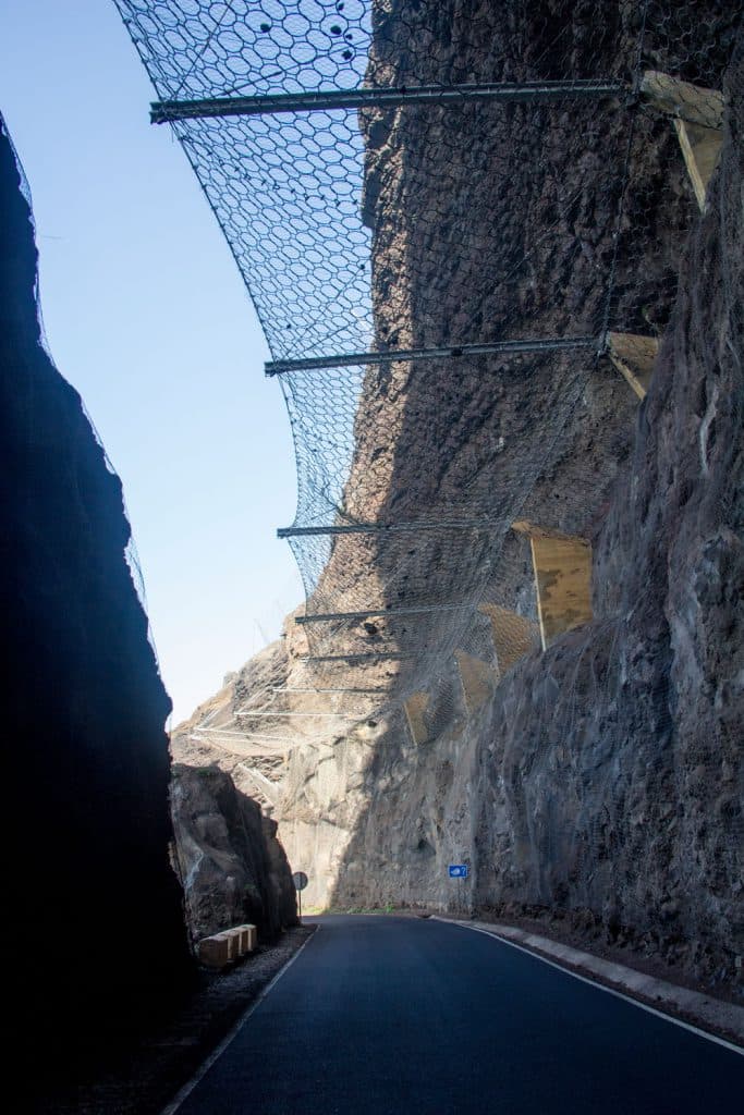
The steel net above the street protects against falling rocks and stones
Only years ago, in 2013-2015, the road was partially closed completely, as there was an acute danger of falling rocks. It was not unusual to see huge pieces of rock on the road. Now the endangered area is secured with large steel nets on the rock walls and above the road. If you walk under the nets, you will see many pieces of rock in all sizes that have been caught by the close-meshed nets.
Risco Steig over Teno Alto in combination with the Punta de Teno
The Punta de Teno is the most northwestern point of Tenerife. There is a lighthouse (Faro del Teno) that was rebuilt in the middle of the 70s of the last century and replaced its old predecessor. The whole „tip“ around Tenerife’s northwest tip is really worth seeing – nicely laid out and equipped with a bathing place.
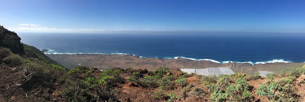
Panorama view on the coast with Punta Teno
Thus, it is possible to visit the northwest corner of the island either as an extension of this Risco Steig hike or afterwards. In good weather, the islands La Gomera and La Palma are visible from the Punta de Teno. Along the southwestern rocky coast, the view reaches as far as Los Gigantes.

Track Risco Steig - view South East
General information about the circular hike over the Risco Steig
Starting point and approach
Starting point of the Risco Steig hike is the road Carretera Casablanca TF-445 (Km 2.5) – not to be missed, as from here the road is also closed (2017). Parking is available at the roadside.

closed road to Punta Teno
By car
From Buenavista del Norte on TF-445 towards Punta de Teno to the roadblock at km 2.5.
By bus
The Titsa bus line 369 runs between Buenavista del Norte and Punta de Teno at a special fare of € 1 (as of July 2021). Otherwise, you can take a taxi from nearby Buenavista del Norte to the Risco climb. You can find out how to get to Buenavista del Norte by bus (lines 107, 355, 363, 365, 366) on the Titsa homepage . 
Track Risco Steig North West
Time
Article summary and large selection of GPS hiking tracks
Sign up for my newsletter now and get exclusive access to my collected GPS tracks as well as all the brief information about my articles.
Sign up nowI don’t like to give general time information for hiking tours, because the times are very individual. For this tour I needed about 5 hours with breaks and an extensive coffee in Teno Alto.

elevation profile Risco Steig via Teno Alto
Difference in altitude and distance
The difference in altitude is about 850 meters and the distance is about 13 kilometers.
Hiking overochre-coloured rocks
Requirement
For the ascent Risco Steig you should be free of vertigo and sure-footed. After the Risco Steig it is a leisurely hike over the high plateau and down to the coast. On the way back, we walk a few kilometres along the coastal road, which is closed to traffic. A non-illuminated tunnel has to be crossed. Therefore it is important to bring a torch.

Teno Alto - village street with bar
Refreshment
Restaurants, bars and shops can be found in the nearby Buenavista del Norte. On the walk itself there are two restaurants/bars in Teno Alto.
Variants
This tour can be easily combined with various other walks and circular walks in the vicinity. For example, one hiking trail leads from Teno Alto down to El Palmar and another over to TF-436, where hiking trails from Masca, Buenavista del Norte and Santiago del Teide converge. A tour description from Santiago del Teide to Masca, which also crosses this path, can be found here. The tour can also be combined very well with a hike over the Baracán to Teno Alto. Other hikes around Teno Alto include the challenging Teno Alto – Risco climb and adventurous hikes in the northern Teno mountains. 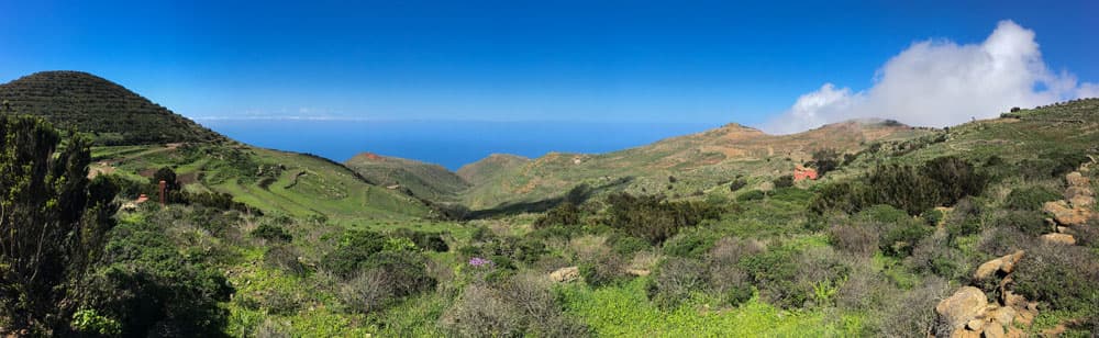
Panorama - green plateau at Teno Alto
Of course, the tour can also be done in the other direction as a round tour. If the hike with Risco Steig and Teno Coastal Road is too long for you, you can only take the Risco Steig to Teno Alto and back again. And if the tour over the Risco Steig is too steep for you, you can also start from Teno Alto and go down to Punta de Teno or/and to the starting point of the hike. Finally there is the possibility to hike up from the starting point or the Punta de Teno to Teno Alto.
You see – in this beautiful corner of Tenerife you have many possibilities to hike.

Ascent Risco Steig - steep rock paths close to the gorge
Hike Risco Steig via Teno Alto to the coastal road
Route section Starting point at the TF-445 up to the rock terrace

starting point and the street - information board
You start your Risco Steig hike at the road TF-445, where you can see a big hiking board. Follow the PR TF 58 trail along the initially wide path past a large water reservoir. The path quickly becomes narrower and steeper. The path climbs over stones in a small Barranco (Barranco de la Torre). After some time the right side of the slope climbs steeply.
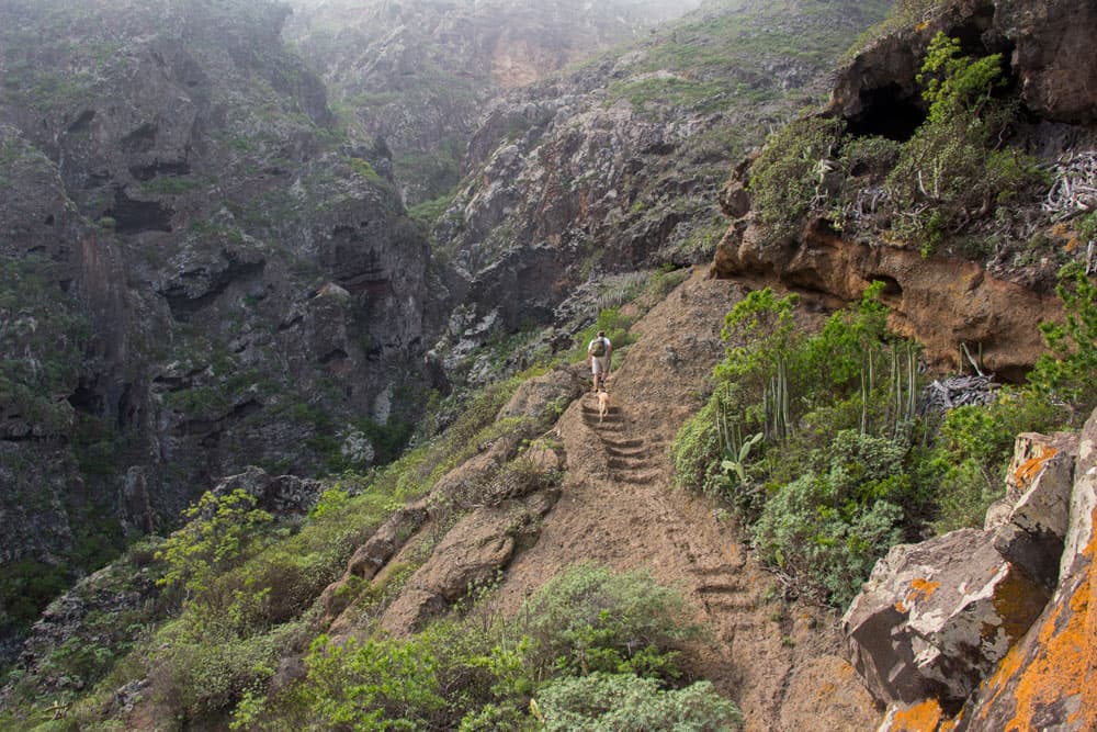
The stream bed and the large water reservoir below you quickly stay behind. You climb steeply up steps and narrow serpentines. The views of the north coast become more beautiful with every vertical metre. After about 30 minutes you will reach a small viewing terrace made of rocks. From there a path branches off to the right. However, you go around to the left over the rock steps, which lead you closely along the slope.

ascent Risco Steig through the stony barranco
Section from the rock terrace to the plateau
On the left side it goes now partly steeply downhill, so that head for heights should be given. On your steep ascent in this area you will cross three rocky outcrops. The third ledge is a bit „airy“. Just below you lies the Barranco de la Torre and steep rock faces in front of you. You pass a rock cave. The view is fantastic. Unless clouds suddenly come up. That’s how I felt on the last ascent to the Risco Steig. So for some time there were only rugged rocks and clouds around me. But the impressive experience of the ascent remains.

view back from the Risco Steig to Buenavista and the sea
Another half hour we climbed steeply up the rock face. You cross a small Barranco gully and climb up the other side of it. No end of the steep ascent is yet in sight. You walk over small rock terraces and then again on rock steps and narrow paths. At the edge of the Barranco you continue uphill. The path makes a wide bend to the right along the rock face. Finally it goes over red rock and suddenly you are standing on the plateau. The steep climb is finished.
Article summary and large selection of GPS hiking tracks
Sign up for my newsletter now and get exclusive access to my collected GPS tracks as well as all the brief information about my articles.
Sign up now
hiking path over red rocks - Risco Steig
Section from the plateau to Teno Alto (Los Bailaderos)
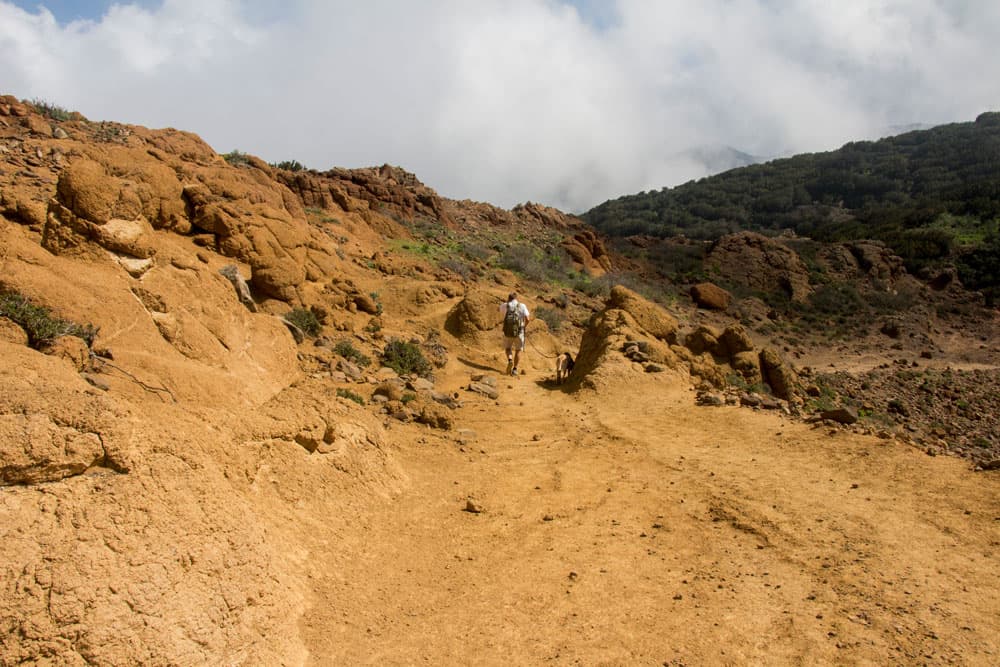
You started at 120 meters and have already reached 650 meters. Back here you have a beautiful view of the north coast. In front of you the view opens to wide green valleys and gentle hilly landscapes. Here there is a circle of stone walls dating back to the Guanches. Walk past the stone circle and keep left with your PR TF 58 hiking trail. It goes briefly downhill and then uphill on red rock in a small valley.

HIking path on the plateau - stone circle from the Guanches
After some time you will come to a path that leads you slightly uphill on a slope along green meadows and goat pastures. Once you have reached the ridge, continue straight ahead and descend to a crossroads visible from afar. From there you only follow the road that climbs in a wide curve, which after a short time takes you to the hamlet of Teno Alto (Los Bailaderos). The perfect place for a rest – whether in the Tapas Bar or on the green meadow.

hiker on the plateau walking through terrace fields
Section Teno Alto (Los Bailaderos) to Barranco de las Cuevas

the little village Teno Alto
In the hamlet of Teno Alto many hiking trails converge (see also variants). You follow the path PR TF 51, which first leads you on a road (Pista las Cuevas) from the village and along meadows towards the coast. After a short time you will reach a ridge. The road branches off to the left. Here you leave the road and follow a wide road down to the right.

goatherd in Teno Alto
Later the road meets the road that you cross and continue on the other side. After a few minutes you are back at the road, which you now follow around to the left for a short time. Then the path leads you away from the road and for a while along the upper slope of the Barrancos de las Cuevas.

landscape Teno Alto
Section Barranco de las Cuevas to Roque Chiñaco
You walk along the Barranco edge until you hit the road again. Follow it downhill for some time past houses. But soon, in a right bend, the path leaves the road again and continues down the Barranco de las Cuevas. You walk for a while until the path leads you back onto the road at some houses. Here at the Barranco Grund you cross the Barranco and then follow the path around to the left.
Risco Steig - descent from Teno Alto on a hiking path close to the Barranco

Goat grid at Teno Alto
This leads you now in long wide curves along the slope towards the coast. On the way you come to a goat fence, through which you go straight on. Please close the grate again afterwards. The path ends on a kind of hill. Here at Roque Chiñaco is a nice viewpoint for a rest. You have a wonderful view of the area around the Punta de Teno directly in front of you.

hiking path down to the coast
Roque Chiñaco section
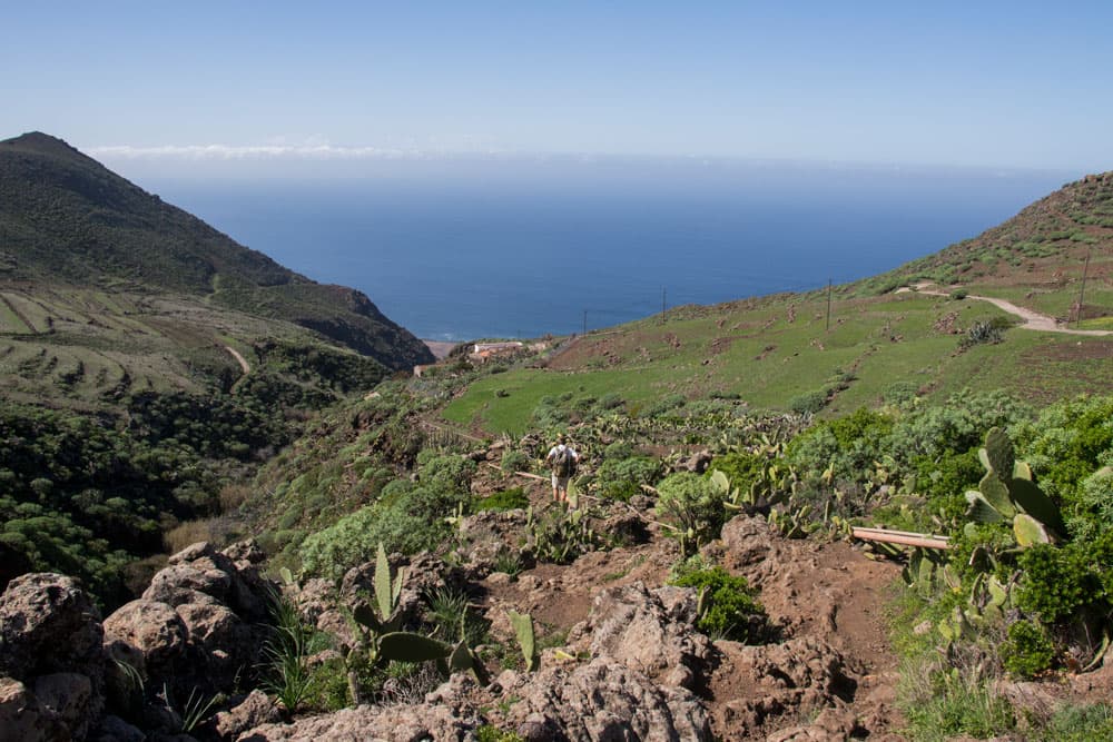
From Roque Chiñaco the narrow descent path leads in wide serpentines down to the road. It takes you from 400 m to 90 m to the TF-445. Next to a large plantation, you finally return to the road. If you still have time, desire and energy, you can go left around to the Punta de Teno. If you stay there, it should take about an hour.

view to the coast close to Punta Teno
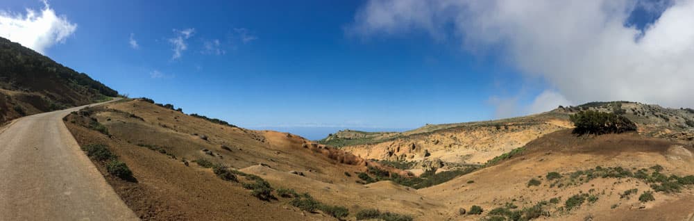
Otherwise you can get back by taking the TF-445 to the right. The road is closed, so there is very little traffic (buses, taxis, authorized vehicles). It is about 4.5 kilometres to the starting point. First, the coastal road goes uphill with magnificent views of the sea and the cliffs. You come through an unlit tunnel and finally to the Mirador de Don Pompeyo. From there you can enjoy the view of the north of the island again. And from the Mirador it’s a short descent back to the starting point of the hike.

hiking route - road to Buenavista
And finally
Also today I hope that you will like this beautiful round tour in the extreme northwest of Tenerife. If you want to walk back on the road, don’t forget to bring your flashlight. I wish you a lot of fun while hiking.
Dagmar von SiebenInseln
sandy plateau at Teno Alto