Hikes in the northern Teno Mountains
As I live in the Teno Mountains on Tenerife, this area is of course my favourite hiking region. I have already described many hikes in the Teno Mountains on the Seven Islands. Today I would like to introduce you to two more tours in the northern Teno Mountains below Teno Alto. 
View of the plateau, the break-off edge and the neighbouring island of La Gomera
Map

the rocks mark the end of the steep ascent path and the beginning of the plateau - northern Teno Mountains
Today we start on the first hike in the northern Teno Mountains below the small village of Teno Alto. From there, the trail first leads slightly downhill across the plateau to the edge of the cliff. Then the trail descends on steep serpentine paths to the coast. Once you reach the bottom, you hike a little along the road, which is hardly used. After a short while, however, you will head up again on a wild little path to the starting point. The ascent leads over the Barranco Itóbal. A wild steep barranco with a dam and a dried-up reservoir.

Barranco Itóbal dam without water
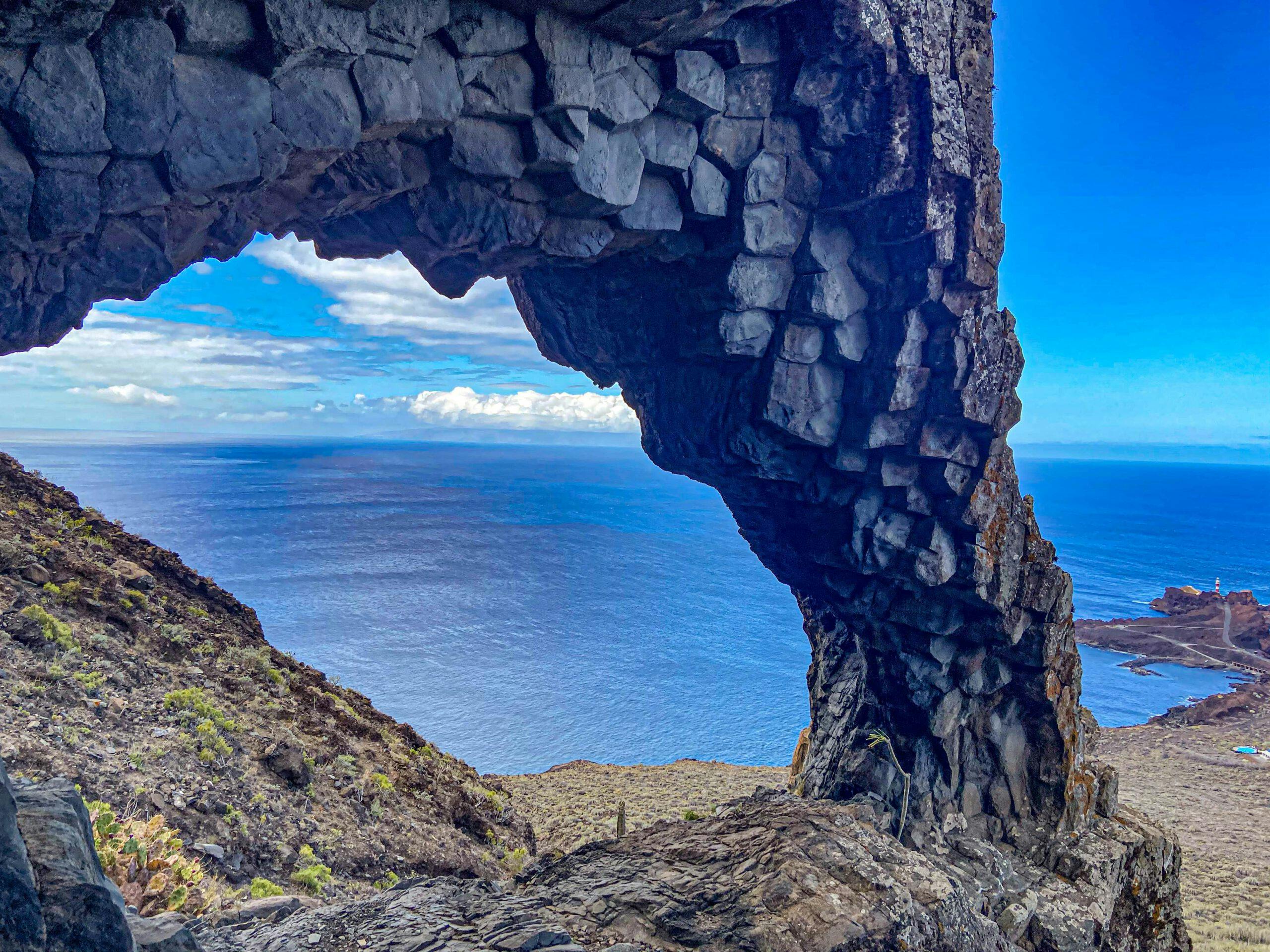
Another rock gate in the northern Teno Mountains
The second hike in the northern Teno Mountains takes you down to the coast, also below Teno Alto. But this time you don’t go right, but left. You hike across to the coast above Punta Teno. From there you can walk a little further along the cliffs and, if you want, visit a rock gate on the way back. In the Teno Mountains I have already described the tour to the rock gate El Bujero. 
View of the cliffs and Los Gigantes in the background from the path on the cliff edge
Both tours are not suitable for everyone, as a good head for heights and surefootedness are essential. This tour to the rock gate above Punta Teno is without any path and therefore not necessarily suitable for imitating. But if you like scrambling and a little climbing, you can give it a try. The view through the gate to Punta Teno compensates for the effort.
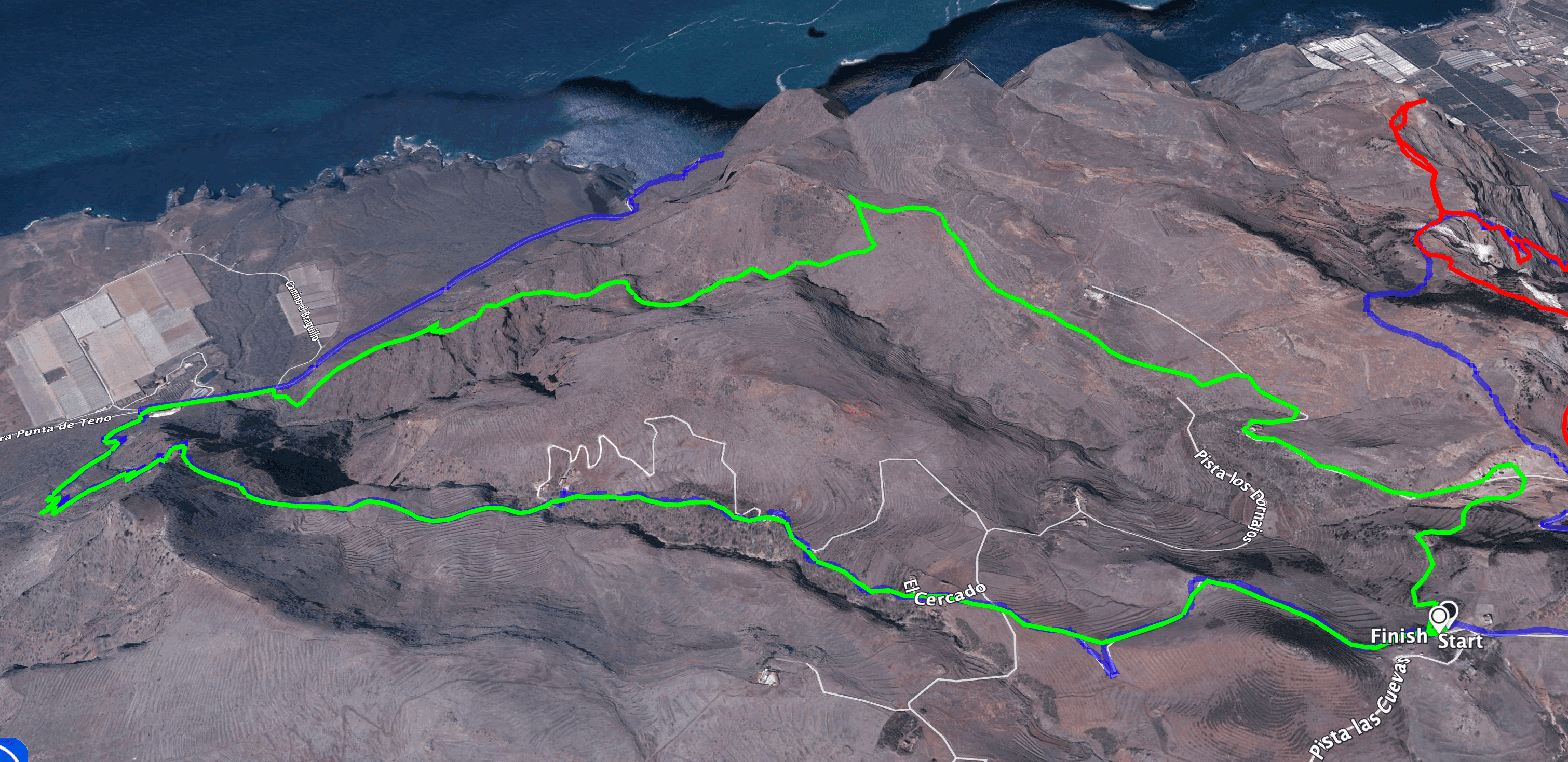
Track of the hike in the northern Teno Mountains
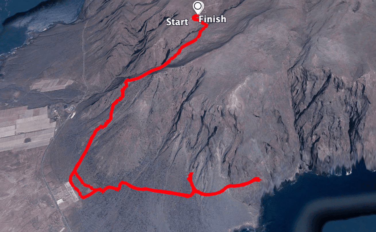
track of the hike to the rock gate
General information about the circular hikes in the northern Teno Mountains
Starting point and directions
For hike 1 (round trip), the starting point is below Teno Alto at the end of the first straight of Pista las Cuevas. There is a small square there that is perfect for parking.

Starting point of the hike to the rock gate at the end of Pista de las Cuevas
For the hike to the rock gate, you can continue down the Pista de las Cuevas towards the coast. It ends at some small farmsteads. You can park here.
Access by car
From the south or north, take the TF-436 (Santiago del Teide – Buenavista/Los Silos). In El Palmar, turn off the road and follow the signs to Teno Alto – Los Bailaderos. At the end of the long serpentine road, you will reach the town of Teno Alto, which you have just passed through. Behind the town you are already on the Pista las Cuevas. At the end of the first straight you will reach the starting point of the 1st circular hike and at the end of Pista las Cuevas the starting point of the 2nd hike to the rock gate.
Access by bus
There is no bus service to Teno Alto, so you will have to rely on a car or alternatively a taxi from El Palmar.
Time
Article summary and large selection of GPS hiking tracks
Sign up for my newsletter now and get exclusive access to my collected GPS tracks as well as all the brief information about my articles.
Sign up nowI don’t like to give general times for hiking tours, as the times are very individual. For the first hike (round tour) we needed 4.5 hours with some breaks and for the second hike to the rock gate 4 hours.
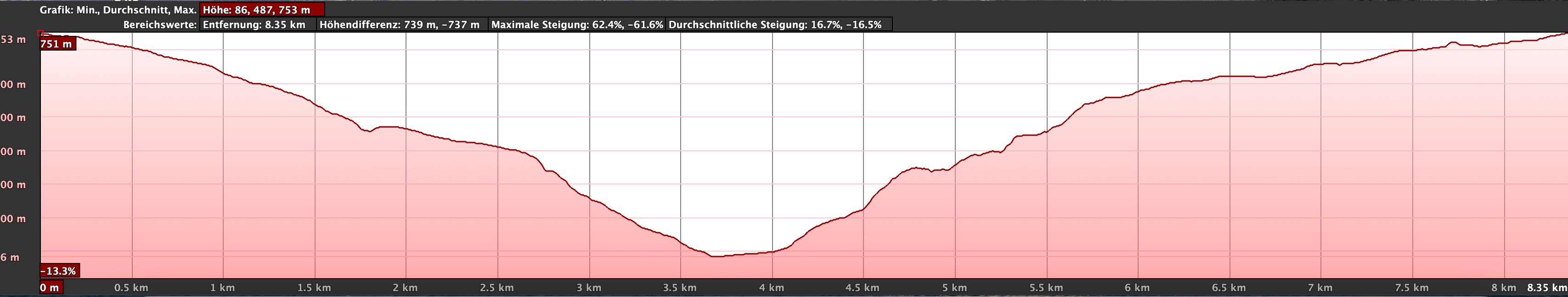
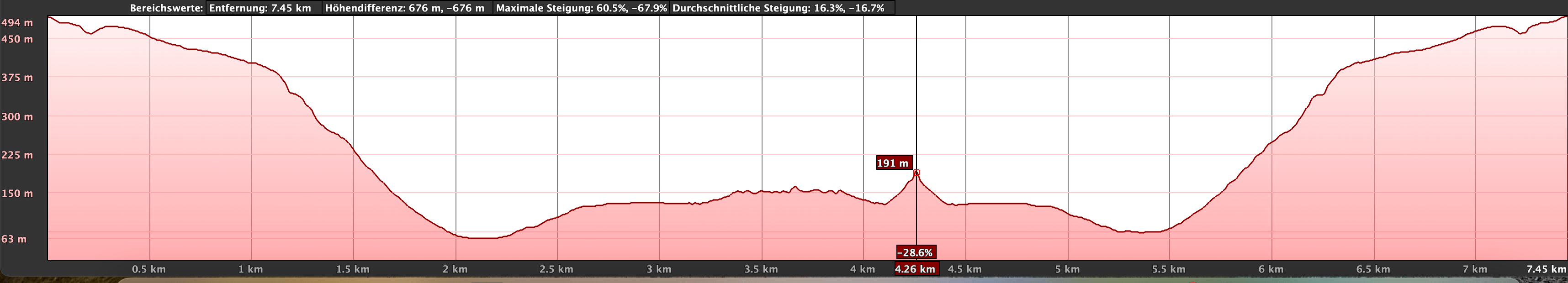
Altitude profile of the hike in the northern Teno Mountains below Teno Alto and back via Barranco Itóbal
Difference in altitude and length of route:
The first hike (round hike) is about 9 kilometres and the second hike to the rock gate is 8 kilometres. On both hikes you will have to climb and descend approx. 750 metres.
Altitude profile of the hike to the rock gate
Requirements
Both hikes are difficult and certainly not suitable for everyone. The first section of the round hike (downhill) is easy to moderately difficult and runs along a hiking trail. However, the ascent is steep and the path is often not easy to find. You need a head for heights and surefootedness. The second hike is down and up on a normal official hiking trail. But the middle part along the coast and to the rock gate is on narrow paths and partly without a path. A head for heights and surefootedness are absolutely necessary. This middle section is really only recommended for experienced hikers.
Refreshments
There are restaurants and bars only in Teno Alto. Therefore, take enough water and, if necessary, food with you.
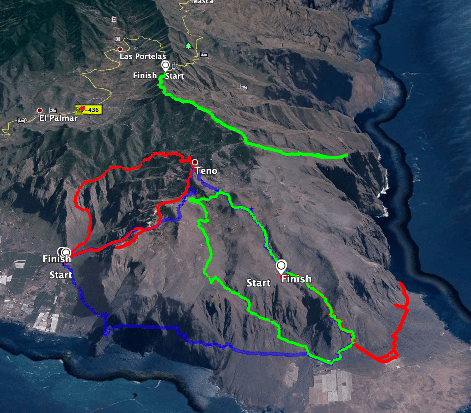
Tracks of some tours in the northern Teno mountains - green middle (the circular hike) red bottom (tour to the rock gate)
Variants

Steep ascent path at Barranco Itóbal
1. Circular hike in the northern Teno mountains in Barranco Itóbal
Pista las Cuevas square to the goat grid behind Barranco de las Cuevas
You start your circular walk at the point where the road branches off to the left. Here you follow a wide road to the right down the slope. Later, the track meets the road, which you cross and continue on the other side. After a few minutes you will be back at the road, which you now follow around to the left for a short while. Then the trail leads you away from the road and for a while directly along the upper slope of the Barranco de las Cuevas. You walk along the edge of the barranco until you meet the road again.

Goats share the trail below Teno Alto with you
Follow the road downhill past houses for a while. But soon, in a bend to the right, the yellow and white marked hiking trail leaves the road again and continues to follow the Barranco de las Cuevas downhill. You walk for a while until the path leads you back onto the road at some houses. This is also the start of hike 2 to the rock gate. Now go down to the Barranco Grund and cross it. Then follow the path that leads you around to the left. This now takes you in long wide arcs along the slope towards the coast. On the way you will come to a goat gate, through which you continue straight ahead. Please close the gate again afterwards.

View of the north coast with banana plantations from the descent path
Goat fence section to ridge path above Barranco Itóbal
The path ends on a kind of hill. Here at Roque Chiñaco is a nice vantage point for a rest. You have a magnificent view of the area around Punta de Teno directly in front of you. From Roque Chiñaco, the narrow descent path leads down to the road in wide serpentines. You will go from 400 metres in altitude to 90 metres in altitude to the TF-445. Next to a large plantation, you will finally return to the road. If you still have time, desire and energy, you can go left around to Punta de Teno. If you stay there, however, this will take at least another hour.

View from the dam wall into Barranco Itóbal
For the circular walk, however, keep to the right along the road. You walk about 2-300 metres along the road and cross the Barranco Itóbal. A short time later, you will see an old, dilapidated chapel on your right. Leave the road at this chapel and walk up the slope. Before you reach the ridge, the path turns left and runs parallel to the ridge for quite a while as you gain height. Finally, the trail climbs steeply up the slope and onto the ridge.

Hiking trail along the road across the plateau - Camino de Mulata
Article summary and large selection of GPS hiking tracks
Sign up for my newsletter now and get exclusive access to my collected GPS tracks as well as all the brief information about my articles.
Sign up nowSection of ridge trail above Barranco Itobal to Camino la Mulata
At first, the path runs above and briefly beside the ridge for quite a while. After a while, it leads you down the right side of the slope to the Barranco bed. Cross the bed and climb up again on the right side of the Barranco. You cross a small plain and then follow the path on the right side of the slope. It is now very steep and you will see a dam wall above you on the left, which you will then reach. Some maps show a lake here. I did not see any water there. However, there are very beautiful views from the dam wall. The path continues through the middle of the wide barranco over the place where there must once have been a lake.

Rock formations near Teno Alto
Finally, the path turns again to the left side of the slope, where a steep ascent follows. On the slope you go relatively steeply out of the barranco and reach a ridge. Up here you will find the remains of an old settlement and a large circular stone circle. The path continues upwards over the ridge. Now the path continues uphill, but at a more moderate pace. The ascent path joins a small road (Camino la Mulata).

Crossing at the Camino de Mulata
Route section Camino la Mulata to the starting point of the hike
Follow this road uphill to the right. You pass a farmstead and continue along the road. Eventually, the colour of the rock changes beside and in front of you. It becomes lighter. And that is why this place is called Paisaje Lunar Teno Alto. You can go off the road a little and look at the bright caves and deformations of the landscape at your leisure. But just before the road forks, you go right over the white rocks onto a small hiking trail. This takes you over the white rocks on the other side of the slope into terraced terrain.

Hiking trail through green meadows and blooming flowers
In spring, it blossoms all around you. The path across the terraces leads you past a large farmstead with another stone circle. Keeping level or with a slight ascent, you follow the path further and further over the terraces and through bushes. Finally, the trail joins the road, where you can return to the starting point of your hike in no time.
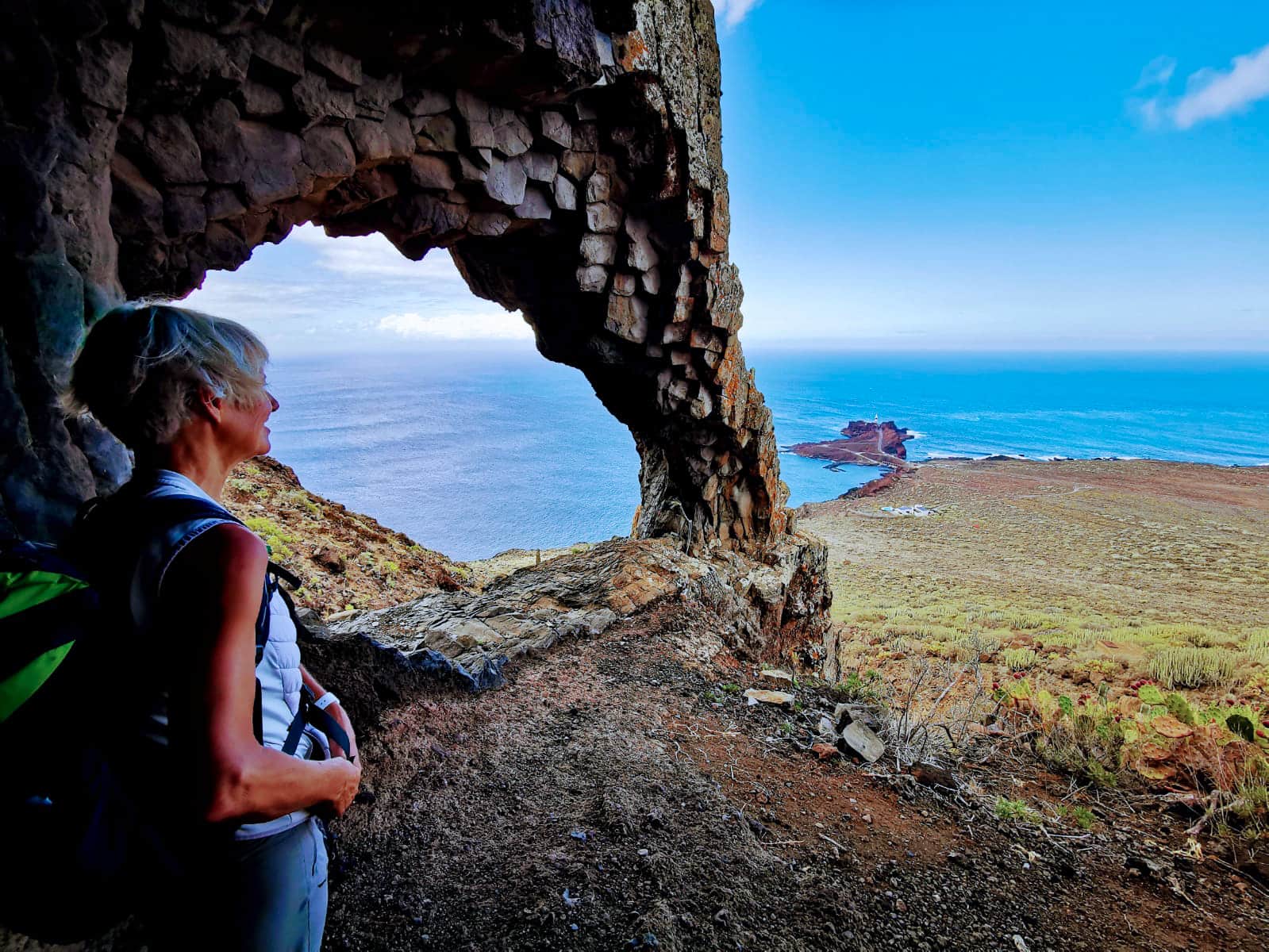
View from the rock gate to Punta Teno
2. Hikes in the northern Teno mountains – hike to a rock gate
Route section end of Pista de las Cuevas to wide ascent path
You start your hike at the end of the Pista de las Cuevas. From here, the hike initially runs parallel to the previous circular hike. You first go down to the Barranco Grund and cross it. Then follow the path that leads you around to the left. This path takes you in long, wide curves along the slope towards the coast. On the way you will come to a goat gate, through which you continue straight ahead. Please close the gate again afterwards. The path ends on a kind of hill. Here at Roque Chiñaco is a nice vantage point for a rest. You have a magnificent view of the area around Punta de Teno directly in front of you. From Roque Chiñaco, the narrow descent path leads in wide serpentines down to the road.

View of Punta Teno from the hiking trail
But before you reach the road, keep to the left at an almost inconspicuous junction. After a while, this path takes you behind a large abandoned banana plantation towards Punta Teno. As the path here is not quite clear, there are several possibilities to go behind this plantation. But eventually you will come to a wider path. Follow this uphill to the left.

View from the cliff edge down into the sea
Route section Broad ascent path to rock gate
Follow the path along the slope. To your left are the cliff foothills and to your right is Punta Teno, which you pass at altitude. At some point you will reach the cliffs. And as on the cliff path before Los Gigantes, here too you go on and on along the cliffs. You have wonderful views of the cliffs, the sea and Punta Teno. I went back when the path only led steeply down the cliffs. As far as I can tell, it doesn’t continue through the cliffs like in Los Gigantes.

View from the hiking trail to the cliffs and Los Gigantes in the background
On the way back, you will see a rock gate at the top right. If you like and can scramble a bit, it is possible to come up in the small barranco. There is no real path. So it’s only something for adventurers. But from the rock gate itself, you have a magnificent view all the way to Punta Teno. A worthwhile excursion for those who like this kind of thing. Afterwards, you take the same path back towards Teno Alto.

eroded earth during the ascent near the rock gate
And finally
I hope you enjoyed the two somewhat adventurous hikes in the northern Teno mountains. But once again the urgent warning that the tours should only be done by experienced hikers. There are also many other hikes of lesser difficulty to discover on Seven Islands. All tours are to be understood as my experience reports only, and not suitable for everyone to replicate. Wherever you hike, I wish you lots of fun and stay healthy,
Dagmar from SiebenInseln