Historic place in Gran Canaria with a long history – Cercados de Araña
I have named this hike Cercados de Araña, because a large part of it crosses the municipal territory of the small town of Cercados de Araña. The name Araña comes from a family of sugar masters who settled in Tirajana in the 16th century. Cercados means fences. In those days, landowners used them to secure their land and prevent their cattle from escaping. Today, Cercados de Araña belongs to the municipality of Bartolomé de Tirajana and had only 57 inhabitants in 2021.
Map

Lonely cave houses at the end of the road and beginning of the Barranco Manantiales - Cercados de Araña gorge trail.
The place was already inhabited by the indigenous people of Gran Canaria, who farmed and raised cattle there. The houses and caves were built with dry-stone walls, closing the openings and leaving only the entrances with wooden doors, and later the „cercados“ (enclosures) were also built with dry-stone walls for cultivation. Today, there is a large reforestation project in the community, replanting thousands of olive, almond, fig as well as avocado trees.

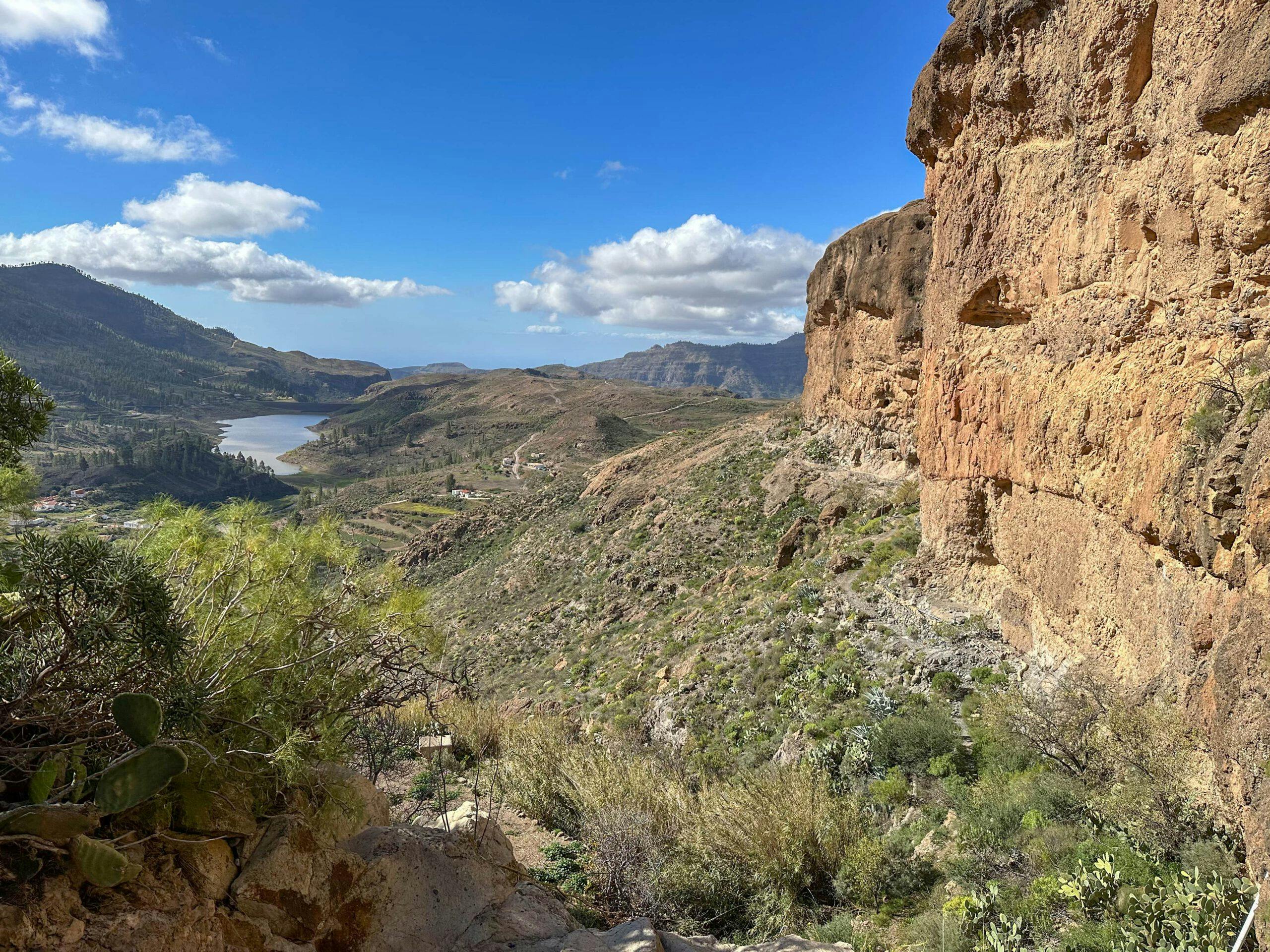
View from the hiking trail in west direction over the wide land areas and mountain ranges around Lake Chira
Diverse and varied hike around Cercados de Araña
This hike takes you from the GC-60 down towards Lake Chira on footpaths. After a while, you will enter the Barranco de los Manantiales (Canyon of the Springs). Here, in addition to the water, you will also encounter large rocks and see the first scattered cave houses of Cercados de Araña. A little later, after crossing the gorge, you will enjoy magnificent views from the slope and canal paths down to Lake Chira.

Hiking trail through the forest above Cercados de Araña through the Barranco de la Plata
You walk in a wide arc down to the lake. From there, you take the trail above the lake and continue slowly back through Cercados de Araña. Finally, you make the ascent towards Cruz Grande through the Barranco de la Plata. Below Cruz Grande, you will then return to the starting point of your hike with impressive views over the small town of La Plata.

Track of the Cercados de Araña hike
General information about the Cercados de Araña hike
Starting point and approach
The starting point of the hike is the junction of the GC-604 road from the GC-60 just before or after the small hamlet of La Plata (27.938663, -15.614906).
Arrival by car
You can get to the starting point on the GC-60 from both the west and the east, just before or after the small town of La Plata. Immediately at the road junction there is a larger square with signs for hikers and numerous parking possibilities.
Arrival by bus
Bus number 18 stops directly at Cruz Grande. You can find more information on the Guaguaglobal homepage. You could therefore also start the hike from Cruz Grande, which is almost bypassed by this hiking circuit. There do not seem to be any bus connections at the starting point I chose here. Article summary and large selection of GPS hiking tracks
Sign up for my newsletter now and get exclusive access to my collected GPS tracks as well as all the brief information about my articles.
Sign up nowTime
I don’t like to give general times for hiking tours, because the times are very individual. We needed almost exactly 4 hours for the whole route with a few breaks.
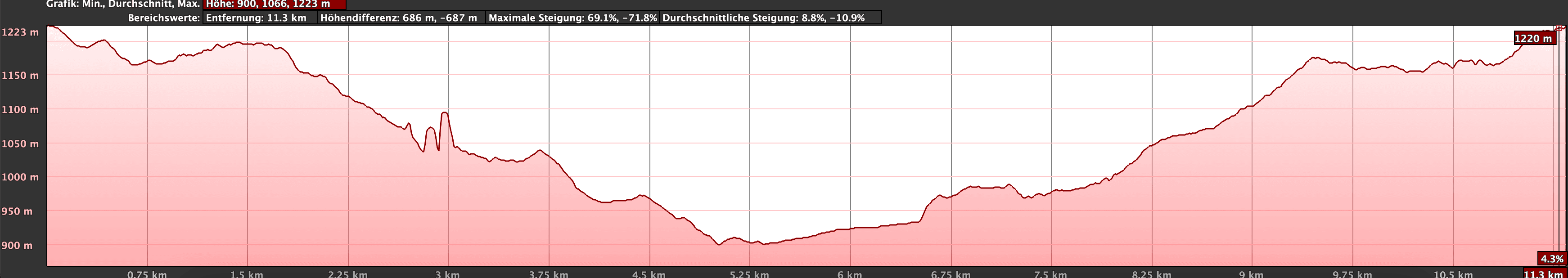
Altitude profile of the Cercados de Araña hike
Altitude difference and route length
The difference in altitude is just under 500 metres and the route is about 12.5 kilometres long.
Requirement
On this hiking tour, you will walk partly on roads, partly on good hiking trails, but also on narrow paths along the mountainside. All in all, this hiking tour is easily doable for every hiker.
Refreshment stops
You may only find refreshment stops if you leave the route and walk into the village of Cercados de Araña. Therefore, be sure to take enough water and, if necessary, food with you.

Track of the hike Cercados de Araña and neighbouring tracks Presa de Chira and San Bartolomé (blue)
Variants
This hike can be easily combined with many other hikes in the vicinity. A small section of the hike above Lake Chira is identical to the hike Great Loop from Soria around Lake Chira. Furthermore, this hiking tour passes close to Cruz Grande. There are still the hikes on SiebenInseln: Small circular hike from San Bartolomé de Tirajana via Cruz Grande and Pico de Las Nieves – Impressive hike on the Cumbre from Cruz Grande. 
in the gorge near Cercados de Arañas above Lake Chira
Hike Cercados de Araña
Route section junction GC-604 from GC-60 to Asadero Cercados de Araña
You start your hike at the road junction of GC-604 from GC-60. There you first hike down the slope to the left of GC-604. At the bottom, cross the road. On the other side, the path takes you up to a ridge, which you cross. On the other side of the ridge, walk downhill and you will come to a track, which you follow around to the left. After a short while, you will come to a larger road.

Starting point of the hike at the junction GC-60 and GC 604
Follow this uphill to the right. After a while you will come to a large barbecue and rest area (Asadero Cercados de Araña), which is already part of Cercados de Araña. We went up to the rest area and then along small paths along the ridge to finally get back to the road. From the Asadero, however, you can also continue downhill on the wide road.
Article summary and large selection of GPS hiking tracks
Sign up for my newsletter now and get exclusive access to my collected GPS tracks as well as all the brief information about my articles.
Sign up now
Wanderweg hinunter nach Cercados de Araña Richtung Chira See am hang entlang
Asadero Cercados de Araña to Presa de Bernadino section
The road ends with two switchbacks at some remote farmsteads and cave houses of Cercados de Araña. From here on, the Barranco de los Manantiales gorge narrows. On the sides you will see huge rocks. In between, cave houses, gardens and watercourses. You walk down through the gorge on a narrow path. An impressive path in a truly remote corner of Gran Canaria. To the left and right of you, you will repeatedly come across isolated cave houses.

Hiking trail in Barranco Manantiales over rocks
Finally, the path ends at a large precipice. Go around it uphill to the left. The path leads you along the mountainside with beautiful views of Lake Chira. You descend along the path to the right and cross the bottom of the barranco. The path then takes you along old canals and below the large rocks down towards the small lake of Presa de Bernadino. You cross a small gorge above the Presa de Bernadino and finally reach a larger road again.

Hiking trail on the cliff high above Lake Soria
Presa de Bernadino to Barranco de la Plata section
Follow this larger road downhill for quite a while. You will enjoy magnificent views of the Presa de Bernadino, Lake Chira and Cercados de Araña. Finally, the trail ends on another road. Follow this path around to the left. It is part of the Soria trail around Lake Chira. At a fork, keep to the right. Now the buildings of Cercados de Araña become denser. You walk along the Barranco de los Ahogaderos (or Barranco de los Cercados) and keep going straight on. 
Hiking trail along an old water canal
The hike around the lake branches off to the right. But go straight on and in the village you will rejoin the GC-604, which you follow uphill to the left for a while. It takes you straight on slowly uphill. At the first hairpin bend, the trail branches off to the right of the road. This trail now takes you uphill again on a beautiful hiking trail to the left above the Barranco de la Plata. 
View from the hiking trail to Lake Chira back to the rocks - Barranco Manatiales
Barranco de la Plata section to the starting point of the hike
Der Wanderweg bergauf ist nicht zu verfehlen und folgt auf der linken Hangseite dem Verlauf der Schlucht. Bei einem kleinen Haus wechselst du durch den Grund die Barranco Seite. Auf der anderen Seite steigst du vorbei an einigen Häusern (wenn du über diesen Häusern den Fahrweg benutzt und diesem bergauf folgst, kannst du die Wanderung ein wenig abkürzen) auf einen Bergrücken hinauf. Das Cruz Grande liegt nun über und nicht mehr sehr weit entfernt von dir. Du überquerst den Bergrücken und steigst danach noch einmal in eine kleine Schlucht hinab. Diese überquerst du und steigst auf der anderen Seite wieder bergauf.

Hiking trail towards Cruz Grande on the slope of the Barranco de la Plata
Der Weg wendet sich nun nach rechts und bringt dich am Hang einer kleinen Schlucht schließlich auf einen größeren Wanderweg. Rechts herum gelangst du nach kurzer Zeit zum Cruz Grande. Zum Ausgangsort hältst du dich jedoch links herum. Der Weg führt dich sehr lange geradeaus und mehr oder weniger parallel zur GC-60 vorbei an einzelnen Häusern und kleinen Ortschaften, wie zum Beispiel La Plata. Im leichten auf und ab gelangst du schließlich wieder zurück zu deinem Ausgangsort.

Hiking trail parallel to GC-60 past the small village of La Plata
And finally
I hope you enjoyed this really varied walk on good footpaths over the fascinating area around Cercados de Araña. I hope you enjoy all your hikes,
Dagmar from Siebeninseln