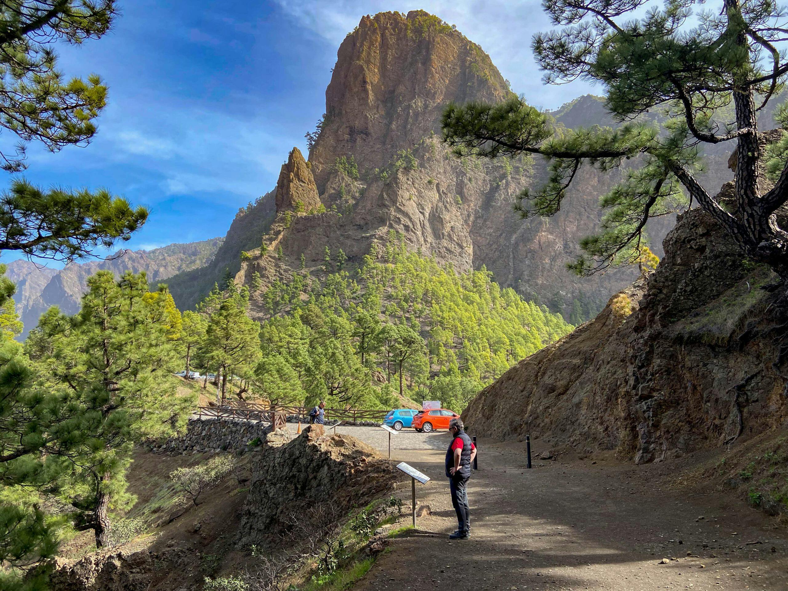
Mirador de La Cumbrecita – impressive viewpoint of the caldera
A road with little traffic (LP 302) leads to the Mirador de La Cumbrecita. But the way there is much more beautiful on the hiking trail built in 2007. It takes you from the small Virgin del Pino church at the foot of the Cumbre Nueva through pine forest in an impressive landscape up to the Mirador La Cumbrecita viewpoint. On the way, you will pass several galleries and a waterfall. The hiking trail is well laid out. But before you reach the Mirador La Cumbrecita, you have to overcome and climb some rock faces.
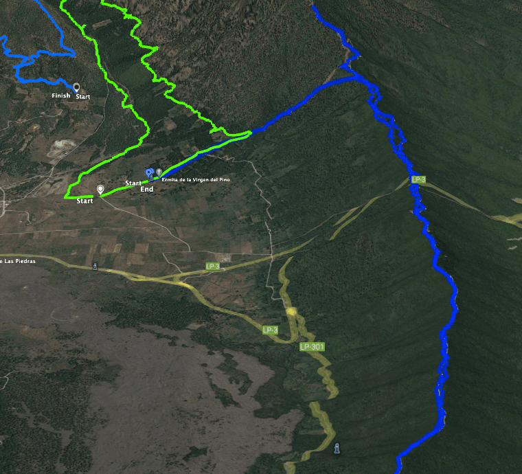
Map

Hiking trail from La Cumbrecita towards Mirador Lomo de las Chozas
At the top, however, you will be rewarded – as on the entire ascent – with magnificent views. You look down into the caldera and back over the entire forested valley to Cumbre Vieja. The Mirador de La Cumbrecita is not only a beautiful viewpoint, but also a hiking hub. From here you can climb Pico Bejenado, for example. You will find numerous other hiking options below under the point Variants. 
Steep rock faces and hard climbs
Of course, you can go back along the same hiking trail. But if you want to do a round trip, I will describe a good way to make a round trip out of the hike. To do this, however, you have to walk the first part of the way back on the road, which is hardly used. But then the path continues through the forest of the Riachuelo valley and along dirt roads until you come back to the Ermita Virgin del Pino.
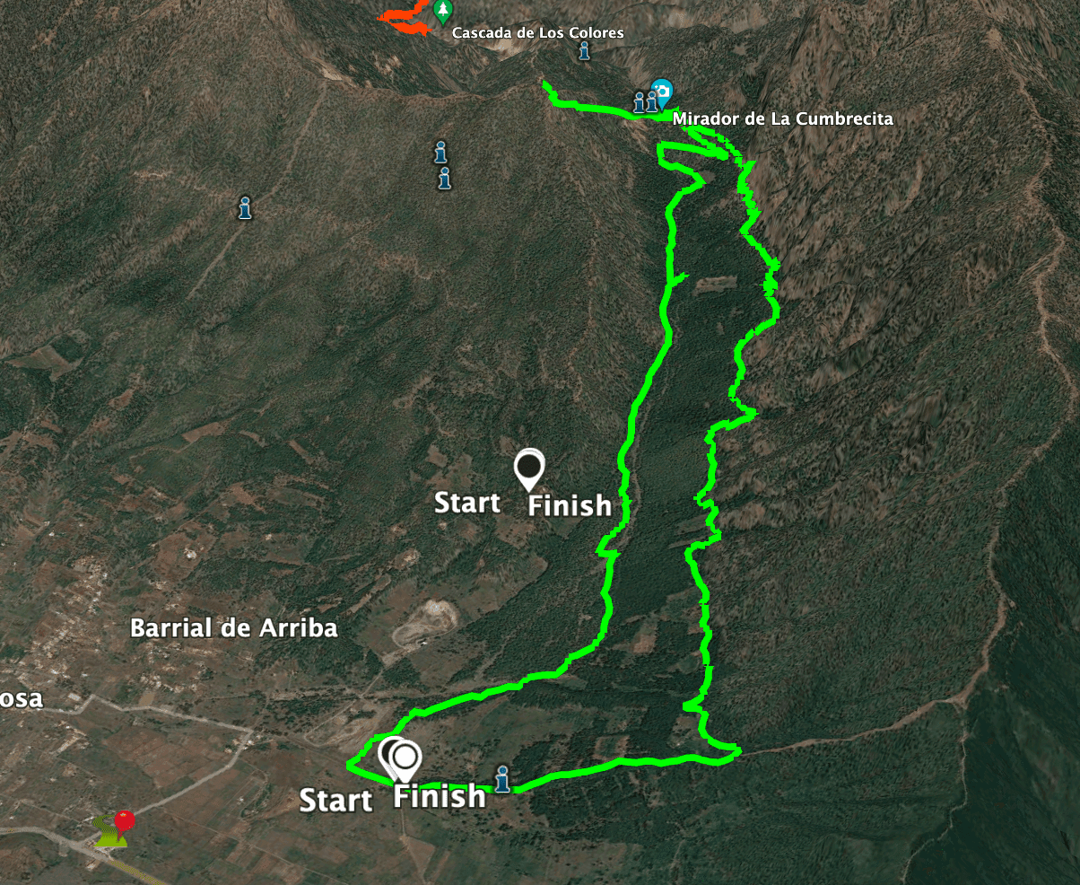
Mirador de La Cumbrecita Hike Track
General information about the Mirador de La Cumbrecita hike
Starting point and approach
The starting point of the hike is Calle Virgen del Pino, which leads to the Ermita de La Virgin del Pino.
Arrival by car
Take the LP-3 and turn off at the visitor centre at El Paso. Continue past the Visitor Centre and follow the LP-302 road. At the first real intersection, turn right onto Calle Virgin del Pino. The road ends at the Ermita de La Virgin del Pino. There is plenty of parking along the road.

Signposting hiking trail La Crucita
Arrival by bus
You can get to El Paso near the visitor centre by taking bus number 300, which runs along the main road LP-3. See the Tilp homepage for details. From there you can take a taxi to the starting point or walk to the starting point (about 2 kilometres). Time
I don’t like to give general times for hiking tours, as the times are very individual. We needed about 5 hours and 15 minutes for this hike with an extensive rest and some additional paths on top of the Mirador de La Cumbrecita.
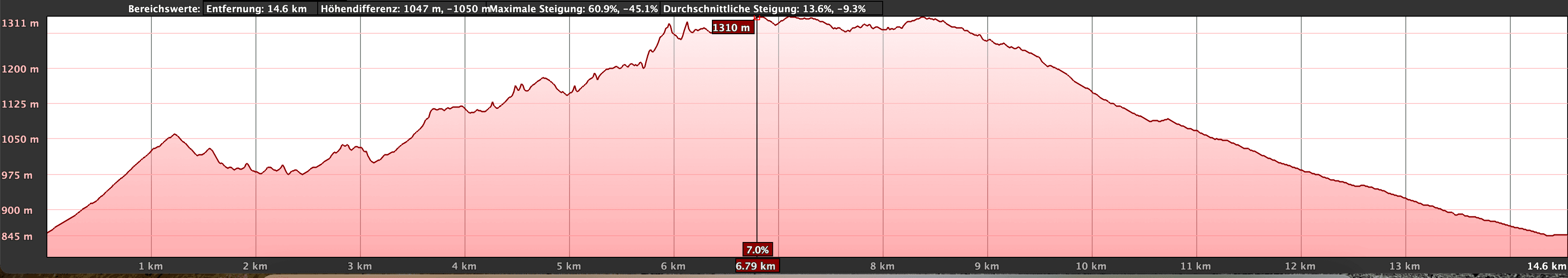
Altitude profile of the La Crucita hike
Article summary and large selection of GPS hiking tracks
Sign up for my newsletter now and get exclusive access to my collected GPS tracks as well as all the brief information about my articles.
Sign up nowAltitude difference and route length
The difference in altitude is about 900 metres and the route is about 17 kilometres long.
Requirement
Basically, the hike is on good paths. However, you should be sure-footed and have a head for heights in some places on the way up. Because of the length and the metres in altitude, you should at least be in good physical condition.
Refreshment
There are no restaurants, bars or shops along the entire route. From time to time, however, a kind of snack bar seems to be open on the Mirador de La Cumbrecita. Unfortunately, it wasn’t open when I was there, so I can’t give any more information about it. Perhaps one of you? Therefore, take enough water and, if necessary, food with you.
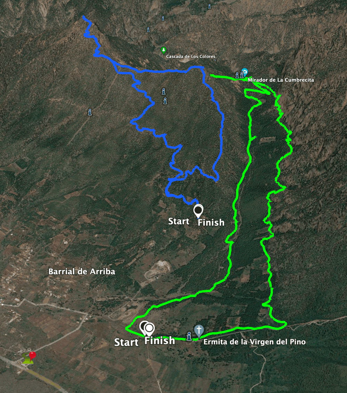
Track La Cumbrecita (green) and Pico Bejenado (blue)
Variantes
This tour can be combined well with various other hikes and circular walks in the vicinity. First of all, you can do the tour as a round trip, as described by me, or as a one-way tour.
From Cumbrecita there is a path up to Roque de Los Cuervos. Here you are also on the circular tour to Roque Bejenado. If you have a long hike in mind, you can also get to Roque Bejenado this way. You can also hike from the Mirador de La Cumbrecita to the Mirador Lomo de las Chozas and the Mirador de Los Roques. This is a small extension (round tour) that takes about 80 minutes. You have very good viewing opportunities at the viewpoints off the coast.
Track Cumbrecita (green) and blue the way up Cumbre Nueva
The hike from La Cumbrecita to Los Llanos across the steep face below Roque Bejenado was closed in February 2022, the last time I was there. Finally, there is a very difficult descent hike from Mirador de La Cumbrecita to Caldera de Taburiente. Several hikers die every year on this narrow and dangerous trail. I can’t say anything about this path, as I haven’t walked it yet.
Finally, you also have other options from the starting point of the hike, the Ermita Virgin del Pino. From there you can climb Cumbre Nueva on steep paths. And then from the ridge, you can hike to the right in the direction of the El Pilar rest area. From there I also described the famous Ruta de los Volcánes. If you keep to the left, you can hike to the Refugio Punta de Los Roques and on to Pico de La Nieve. From there I described the circular hike on the caldera. 
Hiking trail towards La Cumbrecita
Hike to the Mirador de La Cumbrecita
Route section Ermita Virgin del Pino to Galería Única
You start the hike at Calle Ermita Virgin del Pino and first walk towards the small chapel. Behind the church, the actual ascent path begins through the pine forest (PR LP 1, marked in white and yellow) towards Cumbre Nueva. At first, the Cumbre Nueva and La Cumbrecita paths are identical. But then, after a short while, a wide path branches off down to the left. It is signposted towards La Cumbrecita. The path is partly bordered with stones at the beginning.

Starting point of the hike La Crucita in front of the church Virgin del Pino
From here you walk up and down the slope. On the left, you look down on meadows in the valley. Then you enter the forest again. You cross some rocky outcrops, are mainly in the forest at first and sometimes quite close to the foot of Cumbre Nueva. You pass a gallery. Later, the path leads you past a second gallery, the Galería Única.
Article summary and large selection of GPS hiking tracks
Sign up for my newsletter now and get exclusive access to my collected GPS tracks as well as all the brief information about my articles.
Sign up now
Hiking trail through pine forests and along impressive rock faces
Galería Única to Mirador de La Cumbrecita section
The path gradually becomes steeper and winds upwards along the slope. In places you walk through pine forest. Then again you can enjoy wonderful views. After a while, the Mirador La Cumbrecita appears in front of you. You can’t get lost, because the path is a little exposed in a few places, but always easy to recognise. You pass the Mirador de La Laja Azul viewpoint. The higher and further you go along the path, the steeper it gets. Finally, it goes uphill in steep serpentines.

View of the wooded gorge from Mirador de La Laja Azul
Then you walk along the slope again and pass the Galería de Tabercorade. You come to a place where there is supposed to be a large waterfall during the rainy season. When I was there in February 2022, the place was dry, so we could hike on and cross the course of the waterfall without any problems. At the end, the trail climbs steeply up rocky steps. You can already enjoy beautiful views here. Shortly afterwards, you reach the Mirador de La Cumbrecita above the LP 302 road.

up the rocky path on steps

La Cumbrecita with hiking maps and information boards
Mirador de La Cumbrecita section to hiking trail junction
At the top of the Mirador de La Cumbrecita you can do the small extension hike and hike well signposted to the Mirador Lomo de las Chozas and the Mirador de Los Roques. You may also want to continue to Roque Bejenado or perhaps you prefer a summit rest. If you don’t want to go back the same way you came, just follow the Carretera Caldera Taburiente LP 302 road for a while on the way back. 
Hiking trail back along the road with little traffic - the picture does not yet show the junction. You will find it if you continue to follow the road.
This road is not very busy and winds downhill in large serpentines at first. You can shorten the serpentines a little on narrow paths straight ahead through the forest. The road approaches the Barranco de Tenisque more and more. At the point where the road leaves the Barranco, a hiking trail leads into the forest on the left. Follow this path.

Hiking trail through the forest
Section of hiking trail to starting point Ermita Virgin del Pino
You walk parallel to the barranco for a while. Then you cross the barranco and the trail takes you downhill through the forest on the other side. You pass a small settlement, which you bypass. Finally, you will reach a wider path, which you follow downhill for a while. To get back to the Ermita Virgin del Pino, you should leave the path on a path to the left.

Hiking trail along a small gorge - way back
The path runs along a valley through the forest. Finally, you will come out of the forest. Now you can see the road in front of you, to which you can walk along a path between meadows and fields. At the road, depending on where you parked, you have to walk a little to the left to get back to the starting point.

Hiking trail back to the starting point in front of the small church Virgin del Pino
And finally
I hope you enjoyed this beautiful hike on La Palma. The area around the Mirador La Crucita and the Ermita Virgin del Pino is really a beautiful hiking area where you can discover a lot. I hope you enjoy your hikes on La Palma.
Dagmar from Siebeninseln