Anaga circular hike from Cruz del Carmen through the cloud forest
Today’s hike in the Anaga mountains starts at the Anaga mountain road and leads you through the cloud forest and over a scenic valley down to the small village Chinamada. From there you will take a detour to the Mirador de Aguaide high above the steep cliffs.
Map

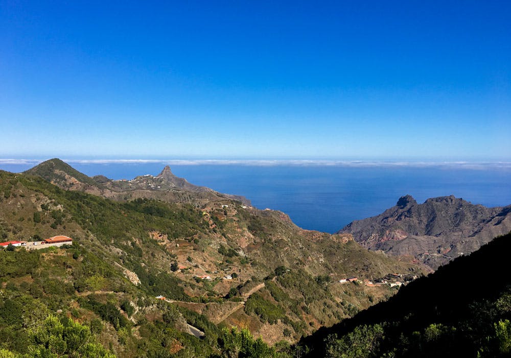
view from the hiking path to Roque Taborno
Afterwards you go in a small circular walk over the original place Las Carboneras and the crossroads Degollada de las Escaleras back to Cruz del Carmen.
Anaga - view down to the coastline - Punta del Hidalgo
Anaga mountain road – most beautiful road of Tenerife with view
In travel and hiking guides about Tenerife you can read that the Anaga mountain road between La Laguna and Chamorga should be one of the most beautiful roads of the island Tenerife. The TF-123 itself is a very narrow and winding road in many places. And therefore it is only very carefully and slowly passable with oncoming traffic from time to time really. But the views to the left and right of the road are really phenomenal. Fortunately, there are many park and stop bays from which you can enjoy the wild landscape of Anaga.
I already described a small circular walk at the end of the Anaga mountain road in Chamorga. Today you don’t have to drive that far. When you have arrived on the high road at 950 metres altitude at kilometre 23, you will find a large parking and viewing area. It is not only today’s hike that starts at Cruz del Carmen. From there, there are actually hiking trails in all directions. If this hike is not the right one for you, you can do many more short and long tours from Cruz del Carmen. A very special hike is the one on the path of the senses (Sendero de los Sentidos). There, hiking is combined with the stimulation of all the senses. 
The Anaga mountain road with fantastic views
Cruz del Carmen – more than just a vantage point
But at Cruz del Carmen on the Anaga mountain road you can do more than just park and walk. Since 1934 there is also a beautifully designed Mirador. From this viewing platform, the view reaches far over La Laguna to Teide and large parts of the island Tenerife. At the entrance to the car park there is the Ermita Cruz des Carmen, a small chapel dedicated to the Virgin Carmen.

Hiking path to Chinamada
On the other side of the road you will find the well-visited Cruz del Carmen restaurant. And for those who want a little more information about the Anaga landscape, there is an information centre about the Parque Rural de Anaga. The center is open daily from 9.30 to 16.00 and in summer until 15.00.
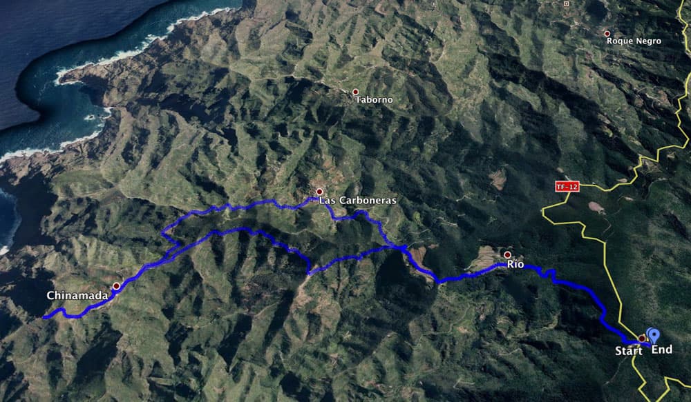
Anaga Track: Cruz del Carmen - Chinamada - Mirador Aguaide - Las Carboneras - Cruz del Carmen
General information on the circular walk in Anaga
Starting point and approach
Start of this tour is at Cruz del Carmen at TF-12 at kilometer 23
Arrival by car
Arrival on the TF-12/TF-123 via La Laguna. There are plenty of parking spaces on the large car park. But lately I have experienced it just on weekends and holidays that really the last parking lot was occupied. Then we park along the street.
Arrival by bus
The Titsa bus lines 273, 275, 76 and 77 stop at the Cruz del Carmen. You can see more island connections on the Titsa homepage. Time
Article summary and large selection of GPS hiking tracks
Sign up for my newsletter now and get exclusive access to my collected GPS tracks as well as all the brief information about my articles.
Sign up nowI don’t like to give general time information for hiking tours, because the times are very individual. For this hike you have to plan a time of about 5 hours with small breaks.
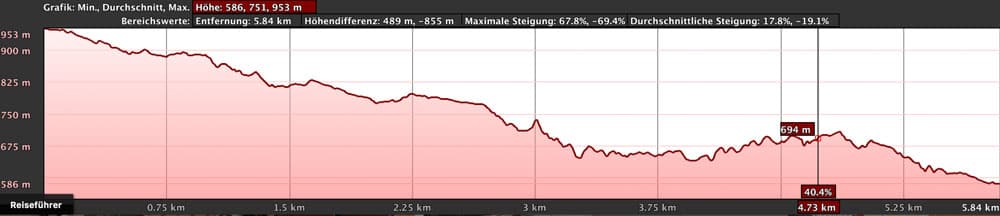
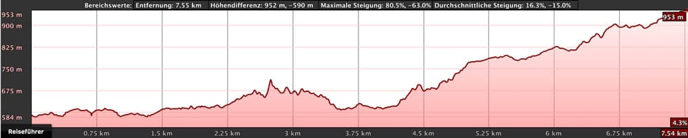
elevation profile Cruz del Carmen - Chinamada
Difference in altitude and distance
The difference in altitude is approx. 600 metres. The distance is 13 kilometres long.
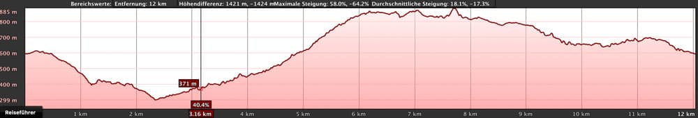
elevation profile Chinamada - Las Carboneras - Cruz del Carmen
Requirement
An easy but long hike in itself. With a little physical condition, the tour can be easily mastered on well laid out hiking trails. The paths are well signposted and usually easy to find.
Refreshment
There are restaurants/bars at Cruz del Carmen, in Chinamada and Las Carboneras. Nevertheless, please take enough water with you for the trip.

Track with a variant - circular Cruz del Carmen - Chinamada - Los Batanes
Variants of hiking tours in Anaga around Chinamada
This tour can be combined well with various other hiking and circular walks in the vicinity of Cruz del Carmen.
elevation profile Cruz del Carmen - Chinamada - Los Batanes
An alternative tour is a big circular hike that follows this tour to Chinamada. But from there it does not go to Las Carboneras, but further down to Batán de Abajo and from there again via Batán de Arriba back to Cruz del Carmen. I marked this tour yellow on the track. However, it is almost 19 kilometres long and there are still 200 height metres (approx. 800 altogether) to be mastered. Irrespective of the length and altitude several inhabitants of Chinamada told me last October 2017 that the way down from Chinamada to Batán Abajo was very dangerous, as it was partly buried. I did not go thereupon. Sure-footedness and a head for heights were probably always necessary for this variant. But I don’t know whether the path can be walked again (?) today. If you have this in mind, it is best to inquire with local residents in Chinamada.
Another possibility is to follow the PR- TF 10 at Chinamada and go down to Punta del Hidalgo on the coast. Or vice versa, but exhausting: From Punta del Hidalgo via Chinamada and Las Escaleras up to Cruz del Carmen. And then there is an option to combine this walk with the circular walk described here from Punta del Hidalgo to El Batán. 
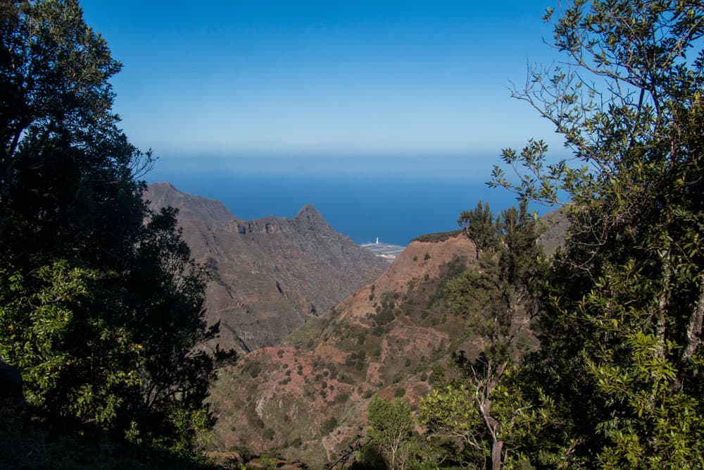
view from the hight to the North side of Anaga
Anaga Hike – Cruz del Carmen, Chinamada and las Carboneras
Cruz del Carmen section up to the road to Las Carboneras
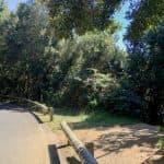
hiking path to chinamada - for a short time on a road
After you have enjoyed the view from the starting point Cruz del Carmen on the Anaga mountain road, it starts on the opposite side of the road. You walk with the PR- TF 10 downhill through the cloud forest. In wide serpentines it goes on relatively well arranged forest ways times less and then again quite steeply down. You follow the white/yellow mark in the direction of Chinamada.
After about half an hour the trail crosses a larger forest road. Then you cross a Barranco and come back to the light with the hiking trail from the dark forest. The hiking trail leads into a wide field path at some houses (Casas del Rio). Follow this path past the small hamlet and fields. Then it goes again for a short time through the forest. And suddenly the path leads to the road to Las Carboneras.

Degollada de las Escaleras
Road to Las Carboneras up to the Degollada de las Escaleras.
You follow the road a little to the left for a short time. Then houses appear on the right side. The path leads away from the street and past the houses. Then it goes along the edge of the field and some steps down around a utility building. At the bottom you cross the road again. Now the path goes steeply downhill on a small path. At the bottom of the slope you are on a saddle with some masts.
Article summary and large selection of GPS hiking tracks
Sign up for my newsletter now and get exclusive access to my collected GPS tracks as well as all the brief information about my articles.
Sign up nowThis is the Degollada de las Escaleras – a beautiful vantage point and a large hiking crossroads. Here you turn left down to Batán de Abajo. Turn right and take the PR TF 10.1 to Las Carboneras. This way you will return here later. This is where the small circular hike starts. But first you can enjoy the view of the Anaga heights and valleys at 715 m altitude.

view from the hight to the mountain village Chinamada
Section Degollada de las Escaleras to Chinamada
You go straight from Degollada de las Escaleras with the PR-TF 10. The path leads you downhill along a scenic path on the hillside. After arriving at the end of the slope, you are on a small plateau with a farmstead (Casa Tamé). Walk past the house on the left and then keep to the right.
The hike continues along the slope. You pass a ruined house and have beautiful views into the Barranco below you and to the distant coast with the Punta del Hidalgo in front of you. After a good half hour you can already see the small place Chinamada below you. The hiking trail leads you up and near the mountain ridge down to the road to Chinamada. Keep left on the road. You can see the houses built in the mountain and the small church square or have a refreshment in the restaurant La Cueva (Monday and Tuesday rest day).

Chinamada - terraces, fields, the chirch and the little restaurant
Chinamada section to Mirador Aguaide and back to Chinamada
The small place Chinamada is pretty to look at and offers itself for a small rest almost. From there a small detour to the Mirador de Aguaide is worthwhile. First you follow the PR-TF 10 through the village past the church square. Then the signposted hiking trail to the Mirador de Aguaide starts on the right. In a short ascent you hike over Chinamada to the right to the steep coast.

Mirador Aguaide with red rocks
The path is easy to walk on and leads across red rocks shortly before the Mirador. From the Mirador itself you can see the steep cliffs of Anaga. Far below you the Atlantic Ocean. And also Punta del Hidalgo is about 5 kilometres away from you. After this little detour you will return to Chinamada on the same way.
Please really go back to Chinamada, because two readers have written in the comments that after this side trip they went downhill towards Punta Hidalgo. Then, of course, there is more height to overcome on the way back.

Anaga - view from Mirador Aguaide to the steep coast
Section Chinamada to Las Carboneras
In Chinamada, on the way back, you go to the point where you came onto the road. But then don’t turn right, just follow the road TF-145 Calle de Montito straight ahead. The path goes along the road for a while. However, this is not bad as there is very little traffic on the road. From a distance you can see beside the striking Roque de Taborno large parts of the northeast of Anaga. The road leads you slightly uphill.
Before it descends again towards Las Carboneras, a signposted hiking trail leads up the mountain on the right. You are now at an altitude of 645 metres. You can find the exact position in the track. For a short time it’s very steep up the mountain. Then along the mountain slope on a beautiful hiking trail towards Las Carboneras. Shortly before the village you meet the road again, which finally leads you into the village and up in the village.

road between Chinamada and Carbonera - start hiking path
Section Las Carboneras via Degollada de las Escaleras back to Cruz del Carmen
The pretty little town of Las Carboneras (meaning charcoal burning) is surrounded by terraced fields. From the church square in the middle of the village you can follow a short circular path through the village. Then the hike continues along the TF-145 Calle de Monito. It goes through the village. A short time later, the PR TF-10.1 goes up to the right of the road on the slope.

Hiking trail below Cruz del Carmen along a rock face with a view of Teide
On the mountain slope the hiking trail leads you partly steeply up again. The path is well laid out and offers beautiful views back to Las Carboneras and the valleys of Anaga. At the end of this stage you are back on the Degollada de las Escaleras. From here you go back to Cruz del Carmen on the PR-TF 10 (description first two sections).

View from the hiking path to Los Carboneras
And finally:
I hope you enjoyed this little circular walk in Anaga. If you have new knowledge about the alternative section Chinamada – Batán de Abajo, I am happy about your message.
If you want more than just a description, just subscribe to the newsletter and receive all tracks and information for free download. Have fun hiking!
Dagmar von SiebenInseln