Arico Viejo – A Traditional Village with Renowned Hiking and Climbing Areas
Arico Viejo is a small, traditional village in the southeast of Tenerife, belonging to the municipality of Arico. It has a relatively small population, with the number of inhabitants estimated to be around 1,000. Overall, Arico Viejo is a quiet, authentic place that has preserved its original charm. Notable sights include the Church of San Juan Bautista, featuring Canarian architecture, as well as several well-preserved traditional Canarian houses that reflect the island’s colonial style. The economy of Arico Viejo is primarily based on agriculture and viticulture. The region is known for the cultivation of potatoes, tomatoes, and local wine. In recent years, tourism has also gained importance, particularly through the growing hiking and climbing tourism.
Map
Hikers and climbers on the way into the Barranco Tamadaya above Arico Viejo
Nevertheless, Arico Viejo remains predominantly an agricultural village that has retained its traditional way of life. Away from the tourist hotspots, this historic place offers a perfect base for a variety of outdoor activities. Surrounded by impressive gorges and mountains, Arico Viejo is especially known for its excellent climbing areas. The surrounding hiking trails lead through wild, untouched landscapes, past old stone houses and through fragrant pine forests. Whether you’re looking for a leisurely stroll or a challenging hike, every hiking enthusiast will find their perfect route here. Arico Viejo uniquely combines nature, adventure, and Canarian tradition.
Circular hike above Arico Viejo
Today’s hike takes you on a beautiful circular route from Arico Viejo, ascending along and over the Barranco Tamadaya. In addition to stunning views and impressive nature, you’ll pass by abandoned houses and caves.
Track of the circular hike from Arico Viejo
General Information about the Circular Hike in Arico Viejo
Starting Point and Access
The starting point of the hike is the Carretera General del Sur in the centre of Arico Viejo (TF-28) at the junction with TF-625 and Calle la Degollada.
Access by Car
From the north or south, take the TF-1 motorway and exit at Poris de Abona towards Arico Viejo on the TF-625. Then drive straight into the village on the TF-625. You can park your car on the roadside at the junction and nearby streets.
Access by Bus
You can reach Arico Viejo and Arico Nuevo by taking the Titsa bus line 430. More information can be found on the Titsa website.
Time
I am reluctant to provide general time estimates for hiking tours, as times can vary greatly depending on the individual. We took just over 4 hours for this leisurely round, including breaks.
Article summary and large selection of GPS hiking tracks
Sign up for my newsletter now and get exclusive access to my collected GPS tracks as well as all the brief information about my articles.
Section from Arico Viejo Centre on the TF-28 to Barranco Tamadaya
You start your circular hike in Arico Viejo on the TF-28 – large junction with Calle La Degollada and Calle La Cruz in the centre of the village. From the TF-28, continue uphill to the right along Calle La Degollada. After a while, you will come to Calle El Molino on the left, with the hiking trail TF-86.2. Follow this hiking trail uphill to the right. For a short time, you will also be on the track of the other two circular hikes around Arico on SiebenInseln. Approximately at the last houses of Arico Nuevo, the road branches off to the left. The TF-86.3 continues straight ahead.
Hiking crossroads above Arico Viejo - junction PR TF-86.2 towards Barranco and Lomo de Tamadaya
However, you continue downhill to the right with the PR-TF-86.2 towards Barranco Tamadaya. The path gradually leads you along the slope, between terraced fields and past individual farmsteads, downhill. Eventually, you reach the bottom of the barranco. After a short while, you walk to the left along the Barranco Tamadaya. Then, you cross over a side ravine to the right side and hike back uphill on the opposite side of the Barranco Tamadaya.
Short detour to old caves along the way
Article summary and large selection of GPS hiking tracks
Sign up for my newsletter now and get exclusive access to my collected GPS tracks as well as all the brief information about my articles.
Section from Barranco Tamadaya to the Junction behind Casas de Tamadaya de Arriba
On the other side, the path leads you along the Barranco Tamadaya for a while. After a short time, you cross over a canal, which you can follow on the right-hand side. Here, you can take a short detour to some caves, which are located above the hiking trail to the right. From up there, you have a beautiful view of the area around Barranco Tamadaya. Afterwards, continue along the hiking trail. This trail continues for a short while parallel to the Barranco Tamadaya, ascending.
Hiking trail past an empty old house - Casas de Tamadaya
The path then climbs to the right in wide switchbacks. After the switchbacks, the hiking trail takes you further along a ridge with stunning views. You will pass the abandoned ruins of Casas de Tamadaya de Abajo and later Casas de Tamadaya de Arriba. Shortly after the latter ruins, a path branches off to the left downhill into the Barranco Tamadaya. This is part of another circular hike in Arico on SiebenInseln, which also leads to Galería Tamadaya.
View from the hiking trail to the Galeria Tamadaya in the Barranco Tamadaya gorge
Section from the Junction behind Casas de Tamadaya de Arriba to the Road towards Arico Viejo
However, on this hike, you do not turn left but continue straight ahead along the ridge. Now, you hike slightly to the right and find yourself above Barranco Chapas de la Jeringa. The path takes you around the right, below high cliffs, over a ravine (Barranco el Seco). Once you have circled the ravine, you could continue left towards Contador and ascend to the Cañadas. On this small circular tour, however, you leave the main hiking trail and turn right.
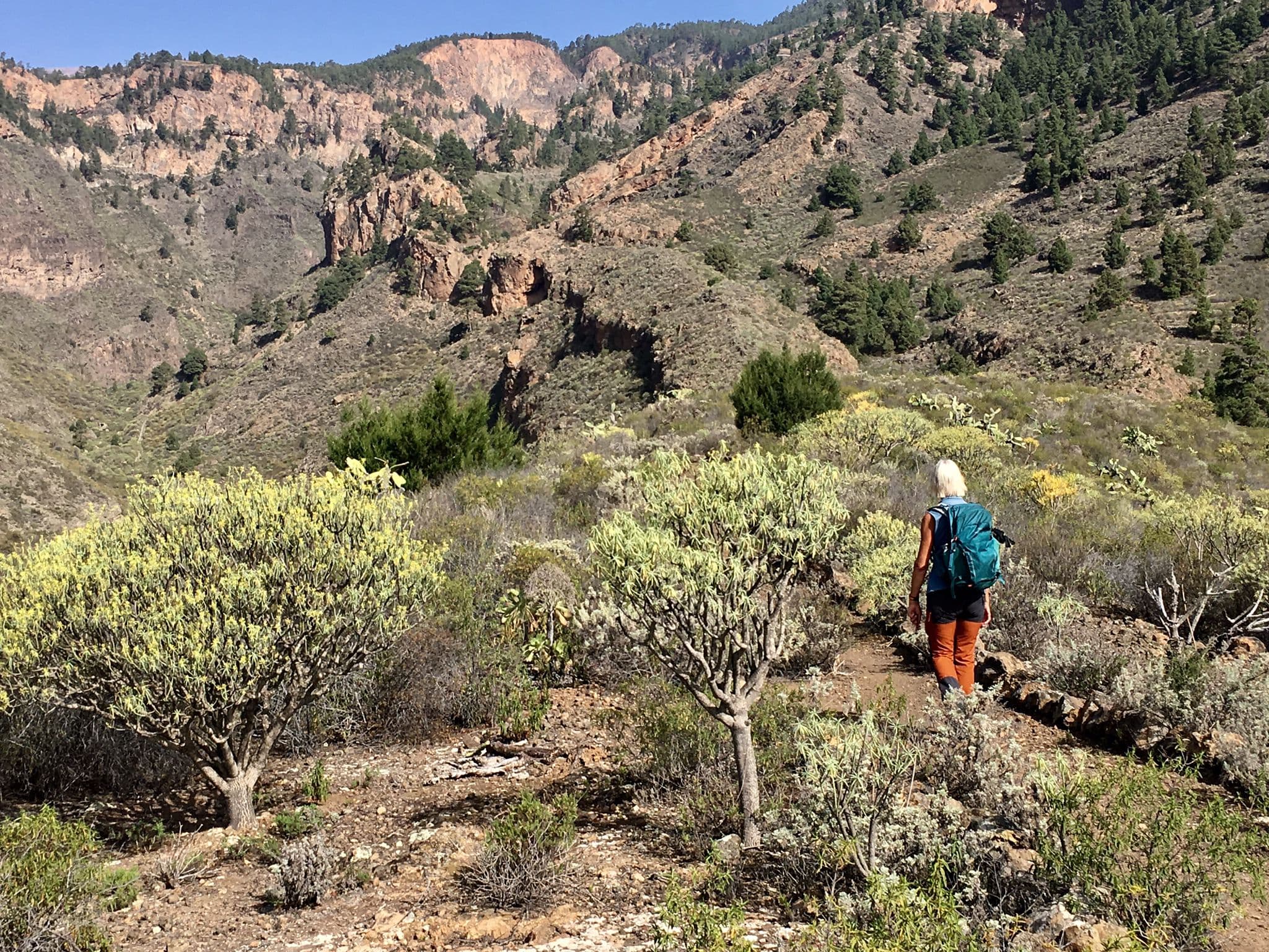
Hiker on the hiking trail above the Barranco el Seco
After a short while, you will reach a wide access road, which you follow further downhill to the right. After some time, the hiking trail branches off to the right from the access road. It takes you along the slope towards Arico Viejo. Finally, you reach a small road, which you follow past houses and fields downhill towards Arico Viejo.
Hiking along old walls above Arico Viejo
Section from the Road towards Arico Viejo to the Starting Point in the Centre of Arico Viejo
You walk through the district of Rodrigo on the road. Here, we made some detours to the right. We did not find a hiking trail, as all the accesses (private land) were blocked. So, to the best of my knowledge, the only way back is to continue straight ahead along the road. This road then takes you further downhill through the district of Las Eritas. Afterwards, you finally reach the TF-28 again.
Hiking trail past old terraced fields with a view back up to the Cañadas
Now, you must follow the road to the right and cross the Barranco Tamadaya once more in a large switchback. On the opposite side of the ravine, continue along the road. It will then take you right back to the centre of Arico Viejo, and thus to the starting point of your hike.
View from the heights towards Arico Viejo
And finally
I hope you enjoyed this circular hike around Arico Viejo, which can be easily combined with many other hikes. Wherever you may hike, I wish you much joy on all your adventures,Dagmar from Siebeninseln.
Dagmar from Siebeninseln
Thank you for reading!
If you've found my hiking guides on SiebenInseln helpful for your Canary Islands adventures, please consider leaving a small tip. Your support is greatly appreciated and helps cover the costs of maintaining this blog.