In February 2023, a small section of the Camino Real del Sur just outside Güimar was closed due to a landslide
The Camino Real del Sur – a historic path from Granadilla de Abona
The entire Camino Real del Sur runs along historic paths between Granadilla de Abona and Güimar. At least, that is the route I am presenting here. You can also extend the route to the southwest and walk from Granadilla de Abona to San Miguel. In fact, I also found some hikes from San Miguel or Granadilla de Abona to Santiago del Teide that were still listed under the name Camino Real del Sur.

View from the hiking trail back to Fasnia - Camino Real des Sur Granadilla de Abona to Güimar
Even I cannot say exactly where the historical path actually ended. Since I am usually asked for circular walks and also prefer them myself, I had so far divided the Camino Real del Sur into individual sections with circular walks. You can find one of them here. Other hikes that touch on the Camino Real del Sur are, for example, the circular hikes around Arico and La Zarza. Map

Hiking trail through a barranco behind Granadilla de Abona
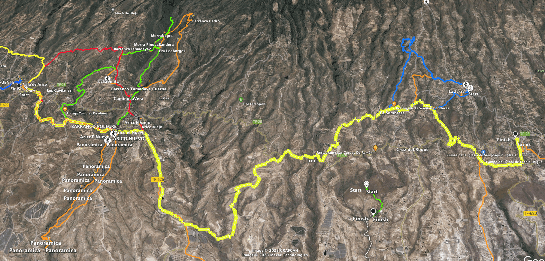
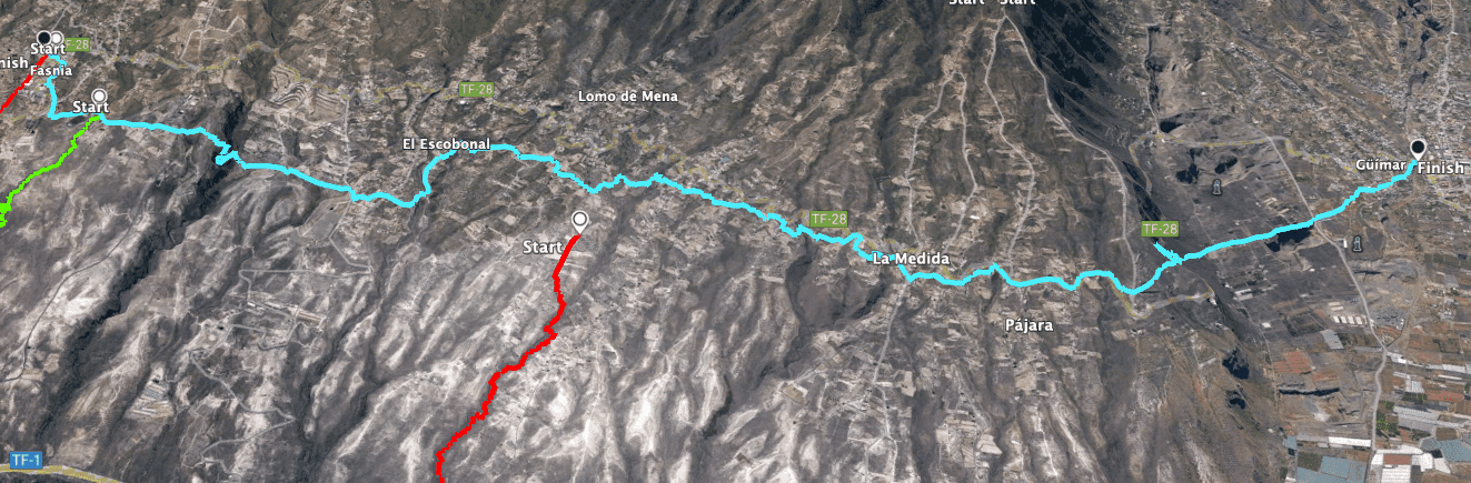
The Camino Real del Sur divided into three sections from Granadilla de Abona to Güimar
This long hike with its almost 53 kilometres and 2200 metres of altitude can certainly be done in one piece by extreme athletes. But if you want to hike in peace and enjoy the nature, the landscape and the small Canary Islands villages, it is a good idea to divide this route into individual sections. I myself divided the route into three sections.

Interesting information along the way - Camino Real del Sur Granadilla de Abona to Güimar
On one day I walked from Granadilla de Abona to Villa de Arico. On another day, we went from Villa de Arico to Fasnia. And on a third day we walked from Fasnia to Güimar. Of course, you can also divide up the sections differently or walk the Camino in the other direction. I describe the Camino Real del Sur in three hikes from Granadilla de Abona.
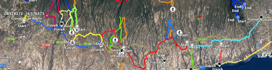
Camino Real del Sur from Granadilla de Abona to Güimar with different tracks of circular walks along the way
Sections: 1. dark blue 2. red 3. light blue
General information about the Camino Real del Sur hike from Granadilla de Abona to Güimar
Starting point and approach
The first hike starts in the centre of Granadilla de Abona on the TF-64. The second hike starts in the centre of Villa de Arico on the TF-28. The third hike also starts in the centre of Fasnia on the TF-28.
Arrival by car
You can get to Granadilla de Abona either from the north or from the south on the TF-28. If you are coming from the TF-1 motorway, take the San Isidro exit and follow the TF-64 to Granadilla de Abona. There are parking spaces all around the town on the road. As long as you stick to the TF-28 or TF-64, you can start the hike anywhere in town. The official start of the hike is in front of the town hall of Granadilla de Abona. There you will also find an information board about the hikes and a reference to the Camino Real del Sur.
If you divide the route as I do, other arrival points are Villa de Arico and Fasnia. You can also reach both places via the TF-28 or via the TF-1 motorway with the corresponding exits.
Arrival by bus
The Titsa bus lines 035, 408, 409, 410, 411, 412 stop in Granadilla de Abona. If, like me, you walk the individual sections individually, you can return to your starting point either by taxi or by bus. In this respect, you should find out in advance where the Titsa buses stop along the TF-28. If you follow my route breakdown, there are bus stops at the end of each route from which you can return to your starting point. Details and more information can be found on the Titsa website. Time
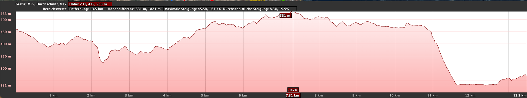
I don’t like to give general times for hiking tours, because the times are very individual. For the first section we needed 5 hours with a long rest. For the second section, 6 hours and 20 minutes. And for the third section about 4 hours.
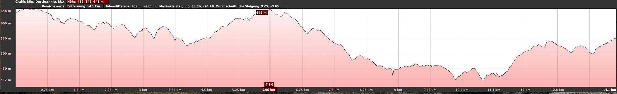
Altitude profile of the Camino Real des Sur Granadilla de Abona to Villa de Arico hike
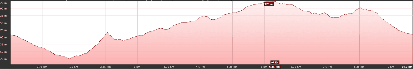
Altitude profile section Villa de Arico to Fasnia
Altitude difference and route length
The difference in altitude on the 1st section from Granadilla de Abona is 685 metres and the route is approx. 16.7 kilometres long. The difference in altitude on the 2nd section from Villa de Arico is 890 metres and the route is approximately 21 kilometres long. On the 3rd section of the route from Fasnia, the difference in altitude is 563 metres and the route is 14.8 kilometres long.
Elevation profile of the Camino Real del Sur section from Fasnia to Güimar Part 3
Requirement
Almost the entire hiking route is on good hiking trails or roads. Only on some small stretches is the path a bit confusing. You should be in good physical condition because of the length of the routes.
Refreshment stops
You will find restaurants and bars at the starting point and often in the small towns you pass through as well as at the destinations. Nevertheless, please take enough water with you for the hikes.
Article summary and large selection of GPS hiking tracks
Sign up for my newsletter now and get exclusive access to my collected GPS tracks as well as all the brief information about my articles.
Sign up now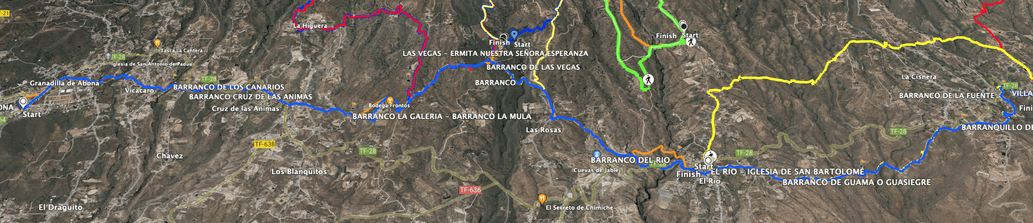
Track of the hike Camino Real del Sur Granadilla de Abona to Villa de Arico
Track Camino Real del Sur - Villa de Arico to Fasnia Part 2
Track of the hike Camino Real del Sur from Fasnia to Güimar Part 3
Variants
The hike can be divided into three parts, as described above. Of course, you can divide the sections differently, walk in a different direction or continue the Camino in Granadilla de Abona.
You can find circular walks that can be combined with the Camino Real on SiebenInseln:

Hiking trail below Fasnia
Hike Camino Real del Sur Granadilla de Abona to Güimar
Hike from Granadilla de Abona to Villa de Arico
Route section from the centre of Granadilla de Abona to the district of Vicacaro
You start the hike in Granadilla de Abona on the TF-64 and walk to the right along the main road. After a short while, this road joins the TF-28, which you continue to follow through the town. At the second major intersection, turn right. After a few metres, a smaller road branches off to the left. This is the street Calle Arquitecto Marrero. Follow this street to the end. At the end of the street, turn right. Then take the first street on the left.

Start of the hike in the streets of Granadilla de Abona
Follow this street to the end. Now you are almost out of the centre of Granadilla de Abona. You walk slightly downhill along a dirt road between fields. Then you will come to a road again, which you follow around to the left. This leads into Calle Vicacaro in the Granadilla de Abona district of the same name. Cross this street and continue straight ahead on Calle la Cruz, slightly to the left. Continue straight ahead on this street, ignoring the crossroads.

Hiking trail near Granadilla de Abona - Vicacaro
Vicacaro district of Granadilla de Abona to Las Vegas hiking trail junction
At the end of the road, the path turns into a hiking trail. This takes you through a small barranco and past more houses and fields until you reach the TF-28. Cross the road and the trail continues on the left side of the road. Then cross the TF-28 again and follow the path on the right. Then do the same again on the left. The trail then turns away from the TF-28 below La Higuera. You walk down from the Barranco de Mocán, which you cross. 
Direction Las Vegas on the Camino Real del Sur - PR TF 83.5
Afterwards, I accidentally went too far and ended up on the grounds of the Bodega Frontos. You should, however, turn left off the path in good time and follow the hiking trail that takes you in a large arc around the Bodega Frontos to the Calle de Lomo Grande. Cross this and you will find a signposted hiking trail TF PR 83.5 towards Las Vegas. Follow this path.

Water pipe by the wayside near Las Rosas
Route section branch off hiking trail Las Vegas to El Río
This trail is also part of the Las Vegas – La Higuera circuit. It takes you over the Barranco de Suarez and the Barranco de Las Vegas to below the village of Las Vegas. The Las Vegas circular hike starts here in the village. However, you cross the Barranco de las Vegas below the village. On the other side, follow the hiking trail parallel to Calle las Vegas. After a while, the trail meets Calle las Vegas, which you follow briefly. 
Hiking the Camino Real del Sur below Las Vegas
Then the trail turns left off the road. You walk through another gorge and on the other side down to the TF-28. You are just before the village of El Río. From here you will also find a great circular hike on SiebenInseln. Follow the road Hoya de las Escobas into the village. There you turn left and walk through the village on small roads parallel to the TF-28. 
Hiking trail near Arico
El Río to Villa de Arico section
Walk out of El Río on Calle la Montaña. The road turns into a driveway and then into a hiking trail. This beautiful hiking trail takes you slightly up and down through some ravines. You walk partly on cobblestone paths and can enjoy wonderful views of the coast. Finally, you will reach the first houses of Arico on Calle las Crucitas. The hiking trail crosses a part of the village and leads you through a barranco to Calle San José.

Hiking trail through a barranco before Arico
Cross this street. You continue straight ahead on the hiking trail and cross two more small ravines. At the top of the second ravine, you will meet the TF-28 again, which you follow to the right for a while. This will take you to the village of Villa de Arico. Here you can finish your first section of the Camino Real del Sur, as I did.
Article summary and large selection of GPS hiking tracks
Sign up for my newsletter now and get exclusive access to my collected GPS tracks as well as all the brief information about my articles.
Sign up now
Villa de Arico - Destination of the 2nd stage of the Camino Real del Sur
Hike from Villa de Arico to Fasnia
Section Villa de Arico to Arico el Nuevo
You start your hike near the TF-28 in Villa de Arico. At the end of the village there is a roundabout. Follow the TF-28 and after a few metres the hiking trail branches off to the right. You walk through terraced fields down into the valley. Below you will meet a road, which you follow for quite a while. Finally, the hiking trail branches off to the left of the road. You walk across a gorge and uphill on the other side. There you meet a road, which you follow around to the left.

Start Camino Real de Sur hiking trail in Villa de Arico
Turn left at the next road and shortly afterwards turn right onto the hiking trail. This leads you downhill for quite a while. You cross a ravine and reach Calle las Cuevas, which you continue to follow straight ahead. This branches off into the Camino Vera de los Cangueros. Continue straight ahead until you reach calle la Cruz in Arico el Nuevo. Here you will find the tracks for the circular walks around Arico. For the Camino Real del Sur, however, go around to the right. The trail also takes you through the town past the small church. 
Church in Arico el Nuevo
Arico el Nuevo to Icor section
JNow you go downhill for a long time, parallel to the TF-625, on the trail that crosses the road excellently to the left and then again to the right. Finally, the trail branches off from the TF-625 in a left-hand bend. Descend a steep slope into the Barranco Tamadaya Cuerna. This section down to the track on the Barranco Grund is a little hard to find and probably the most difficult section of the entire Camino. However, I have not found an alternative myself.

Hiker on the way towards Icor
If you continue along the track and the wide footpath, you will cross another gorge and eventually turn left onto a wide track. This takes you back up the other side of the Barranco del Helecho on wide sandy paths. You walk through an impressive sandstone landscape. And then you will finally reach the TF-28 between the Mirador de Las Eras and the small village of Icor. You now hike around to the right on the TF-28 for a short time and cross the small village of Icor.

Wide landscape with impressive sand and rock formations near Icor - Camino Real del Sur
Icor to Fasnia section
Shortly after Icor, the trail branches off to the left uphill. After a short while you will come to Calle Vista el Balo, which you follow straight on. After a climb, you cross a barranco and continue to climb. You will come to Calle Lomo Oliva, which you follow around to the right. The trail branches off to the left and takes you up through a ravine to La Sombrera. Here you are also on the La Zarza circular route. In La Sombrera you pass the church. 
View from the hiking trail to the coast and small villages above Icor
Shortly afterwards, the trail branches off to the right into the Barranco del Topo, which you cross. You will come out in Sabina Alta. There you go straight down on the Camino La Gloria for a long time. At the bottom you will meet the TF-28 again, which you follow to the left for a while. Finally, the trail turns right off the TF-28. Go downhill for a while and then turn left. You will see Fasnia in front of you and above you. Below Fasnia, turn left onto Calle Obispo Pérez Cáceres. This will take you up into the town to the TF-28.

View from the hiking trail over meadows and fields towards Fasnia
Hike Fasnia to Güimar
Fasnia to La Medida section
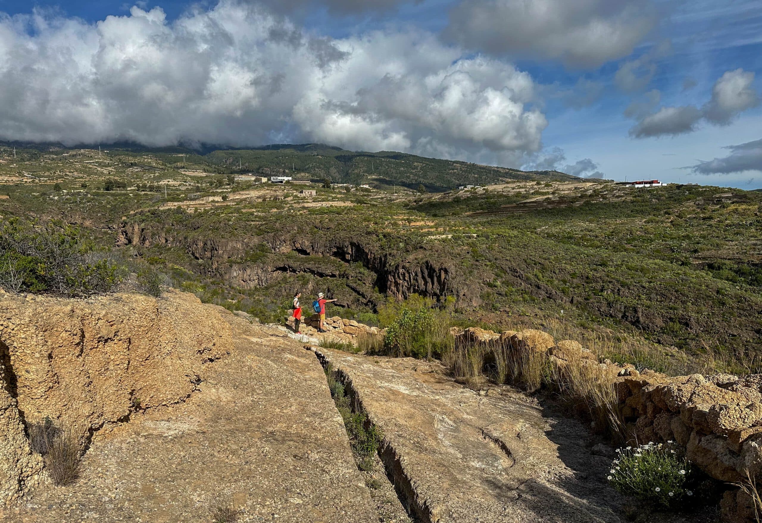
You start your hike at the TF-28 in Fasnia. Walk through the town parallel to the TF-620 down to the football stadium. Cross the stadium on the left. The hiking trail takes you along the slope, slightly up and down, always signposted in the direction of the Barranco de Herques. This barranco is one of the larger and deeper barrancos that you will encounter on the Camino Real del Sur. Crossing it downhill to the bottom and uphill is an impressive experience.

Hikers on the Camino Real del Sur behind Fasnia
On the other side of the barranco, you continue to follow the hiking trail towards Güimar. You will cross a few more small gorges. Then you reach El Escobonal. Here, too, you walk through the village and, behind the village, through another gorge, signposted. You cannot miss the hiking trail on this section. It runs mostly below the TF-28, and the signs to Güimar are usually clearly visible. In addition to some gorges, you will also pass through some small villages. Shortly before the town of Medida, you will come across a beautiful old aqueduct.

Hiking trail through the Barranco de Herques
La Medida to Güimar section
Shortly after the town of La Medida, the trail meets the TF-28 for the last time, so once again you walk along the road. Then, below the Ladera Güimar, the trail branches off to the left uphill from the road. Now the Camino Real goes steeply uphill to the ridge. From the ridge, a hiking trail leads downhill towards Güimar. At the bottom of the slope, the Camino Real continues straight on towards Güimar.

Aqueduct at Medida Camino Real del Sur
When I was there in February 2023, part of this road section was closed due to a landslide. If this continues to be the case, you can think about how to get around this small section. If you follow the Calle de Camino Real straight on, you will end up in the centre of Güimar. You have reached the destination of the third hike and the entire Camino Real del Sur.

View of Güimar from the Ladera - start hiking trail down to Güimar
And finally
I hope you enjoyed these three sections and the Camino Real del Sur as a whole. I’m sure there are other possible combinations to my suggested route. If you notice something during your hike that could be interesting for other hikers, I am always happy to receive information, suggestions and your comments. I hope you enjoy your hike,
Dagmar from SiebenInseln