Camino Real del Sur between El Río and Villa de Arico
The Camino Real del Sur leads along historic paths from Granadilla de Abona to Güimar. You can hike the entire route and, if you like, take the bus back, as it runs largely parallel to the TF-28. The description of the entire Camino Real del Sur route canbe found here. But as I am usually asked for circular walks and also prefer them myself, I have divided the Camino Real del Sur into sections. I have also done individual circular walks on each of these sections. Map

Steep rock faces in the Barranco de Piedra Bermeja on the hiking trail towards Villa de Arico
This way you can do different circular walks and at the same time get to know parts of the Camino Real del Sur. I have already presented such a circular walk in the article Hikes around Arico and the Barranco Tamadaya. Here you can now explore a circular walk that includes the Camino Real del Sur between the hamlet of El Río and Villa de Arico. 
Camino Real del Sur below the road just before El Río
The outward route from El Río to Villa del Arico runs through small valleys and ravines and often along old water channels. The way back from Arico to El Río is on the Camino Real del Sur. On this tranquil hike, you can enjoy magnificent views over the entire east coast of Tenerife and the Atlantic Ocean all the way up to the Cañadas.
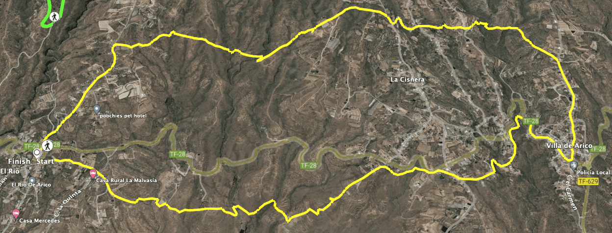
Track of the hike El Río - Villa de Arico - Camino Real del Sur
General information about the round trip Camino Real del Sur – El Río – Villa de Arico
Starting point and approach
The starting point of the hike is the small town of El Río on the TF-28. You begin the hike near the small church of San Bartolomé.
Arrival by car
Coming from the north or south on the TF-1, exit at Chimiche 49. From there, follow the signs uphill to Chimiche. In the town you will meet the TF-28, which you follow around to the right in the direction of El Río. In the village there is a crossroads. Shortly before you reach it, you will find a large car park. If you don’t want to park on the side of the road, you will certainly find a parking space there.
Arrival by bus
The Titsa bus 430 stops in El Río. For details on bus connections and more information, visit the Titsa homepage. Time
I don’t like to give general times for hiking tours, as the times are very individual. I took about 4.5 hours with a hiking group with a long stop in Villa de Arico and another long rest. But the pure hiking time was much shorter (just over 3 hours).
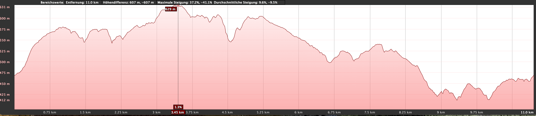
Elevation profile of the El Río - Villa de Arico - Camino Real del Sur hike
Altitude difference and route length
Article summary and large selection of GPS hiking tracks
Sign up for my newsletter now and get exclusive access to my collected GPS tracks as well as all the brief information about my articles.
Sign up nowThe difference in altitude is about 460 metres and the route is a little over 12 kilometres long. The metres in altitude to be hiked are actually about 560 because of the constant ups and downs.
Requirements
This is an easy and very contemplative hike, but you should be in good physical condition because of the length of the route and the metres in altitude.
Refreshments
Restaurants, bars and shops can be found in Villa de Arico. On the day I was there, I didn’t see any open bars in El Río. There is supposed to be a cafeteria in a side street. Nevertheless, please take enough water for the round trip.
Variants
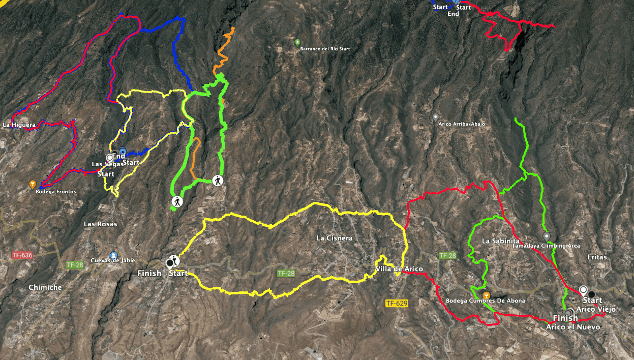
Track Camino real del Sur El Río - Villa de Arico (yellow)and neighbouring tracks (to the right of which are walks around Arico, top left track Las Vegas, La Highuera, El Río dam).
Half of the loop is part of the Camino Real del Sur, so you can of course extend this tour on this trail in both directions from El Río and also from Villa de Arico. In Villa de Arico, combinations with the circular walks around Villa de Arico are also possible. A short part of this hike is also identical to a circular hike around Villa de Arico. 
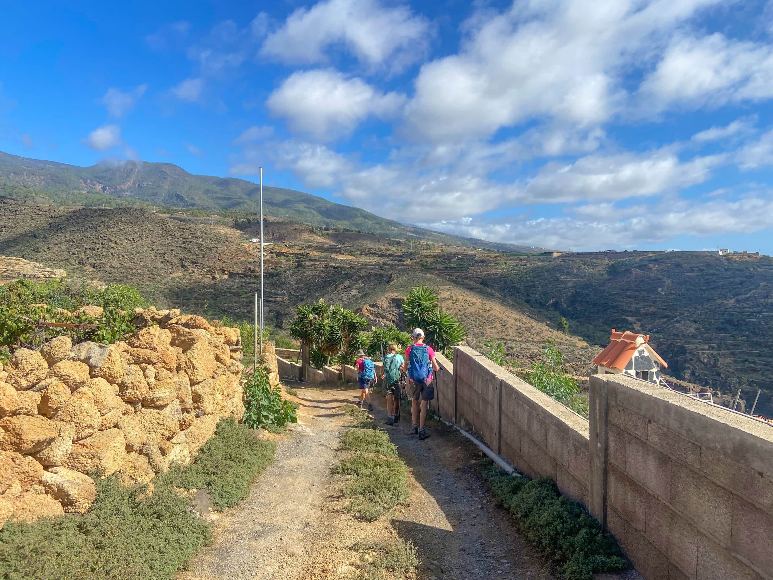
Hiking trail along canals through some gorges
Round trip Camino del Sur – El Río – Villa de Arico
El Río to Barranco del Azúcar section
You start your hike at the main road in El Río on the TF-28. From there, you walk uphill in the centre of the village past the church towards the dam (Calle San Bartolomé). Follow this road for a while until you leave the village. Behind a large white house, the trail branches off to the right uphill from the road. This way you cut a big road serpentine. Back on the road, the trail continues uphill past fields and barren landscape.

View of El Río over the coast and the Atlantic Ocean from the hiking trail
Finally, a well-signposted hiking trail towards Villa de Arico branches off to the right of the road. Follow this wide path for a while. Then it branches off. Turn left and go downhill past a finca. You will then come to the first barranco (Barranco del Azúcar). You walk down and up again on the other side of the barranco.

Hiking trail over El Río towards Villa de Arico
Barranco del Azúcar to la Cisnera section
After you have crossed the mountain range, you will immediately come to the next gorge. You also cross this barranco on the hiking trail. After you have crossed more small gorges, the hiking trail runs along the slope for quite a while, maintaining altitude. From here you can enjoy wonderful views of the east coast of Tenerife, the Atlantic Ocean and high above the Cañadas. You can already see the houses of the hamlet of La Cisnera in front of you.

Hike along old canals
Article summary and large selection of GPS hiking tracks
Sign up for my newsletter now and get exclusive access to my collected GPS tracks as well as all the brief information about my articles.
Sign up nowFinally, in La Cisnera, you come to a small street (Calle San José). Follow it around to the right for a short while. The first street that branches off to the left is Calle San Diego. Continue along this street above the town. At the first crossroads, do not follow Calle San Diego, but continue straight on along the footpath. A road and then a path will take you through another small ravine via La Cisnera to Calle Finca NS Fuente Blanca.

View from the hiking trail in Cisnera over a water deposit up to the Cañadas
La Cisnera to Villa Arico section
In La Cisnera, cross Calle Finca NS Fuente Blanca. On the other side, walk along a wide road for a short while. After a short while, a hiking trail goes downhill to the right, which takes you in large serpentines down into the next barranco (Barranco de Piedra Bermeja). The upper part of this huge barranco is very impressive with its high rock walls. You cross the bottom of the barranco and hike uphill again on the other side of the gorge. On the way up, you also cross the small Barranco Luchón gorge.

Hiking trail from Cisnera towards Villa de Arico
The trail continues along the slope and finally brings you to Calle el Calvarío in Villa de Arico. Follow this to the right downhill through Villa de Arico. This path is also part of the hikes around Arico. You continue downhill through the village, around the church until you finally meet the TF-28 again. Follow this road around to the right for a while. Villa de Arico, with its many bars and restaurants, is also a good place for a rest. 
Hiking junction in front of Villa de Arico - here you will meet the track of the circular hikes around Arico.
Villa de Arico to Barranco del Azúcar section
In Villa de Arico, walk a little along the TF-28. After the first big hairpin bend, you will come to the excellent Camino Real del Sur trail. It goes downhill to the left of the road into the Barranco de Piedra Bermejo, which you have already crossed to the other side. On the other side of the gorge, you will come out on a road in Cisnera. Follow this road around to the left for a while, past houses and individual farmsteads. You will cross another small ravine and finally reach Calle San José again.

Camino Real del Sur behind Villa de Arico and shortly before Cisnera
Cross this street and take a short connecting path to the TF-28, which you leave after a short time on the left. The scenic Camino Real del Sur takes you high above the Barranco Guama, the Barranco de Guasiegre and the Barranco del Azúcar, always parallel to and below the TF-28, back towards El Río. From the Camino Real del Sur, you can enjoy the constant ups and downs with magnificent views of the east coast of Tenerife and the Atlantic Ocean.

View back to Arico
Route section Barranco del Azúcar to starting point in the centre of El Río
Finally, before El Río, the trail joins Calle la Montaña. Follow it straight on for a while and cross Calle la Quinta. After you have walked through the lower part of El Río, you will come to Calle San Bartolomé. You only need to follow it a few metres around to the right. You will then be close to the car park and the starting point of your hike in front of the church of San Bartolomé.

Camino Real del Sur
And finally
I hope you enjoyed this short hike on the east side of Tenerife between the towns of El Río and Villa Arico and on the Camino Real del Sur. Because of the well-laid out trails, this is actually a hike that anyone with a bit of fitness can do. The focus here is on leisurely walking and enjoyment. I wish you much pleasure on all your hikes,
Dagmar from Siebeninseln

Camino Real del Sur - How does an old car get into the gorge?