Barranco de La Orchilla – Historic Resource of Nature
This large circular hike starts and ends at the Barranco de La Orchilla. For a good part of the hike, the trail leads you along the edge of this deep and impressive gorge. You will cross the Barranco twice. Here is some information about the Barranco de La Orchilla. The name of the barranco comes from the lichen plant of the same name (Roccella canariensis tintorera) that grows on the slopes of the gorge. It used to be the source of the dye used to dye the colour purple. Not only textiles, but also chairs, curtains and bedspreads of European palaces were dyed purple with the orchilla.
Map
Barranco de La Orchilla
The gathering of the orchilla in the barranco of the same name has been documented since the end of the 15th century. It was dangerous work, as the collectors had to move along the inaccessible exposed and steep rock faces in order to harvest the plant there. For the inhabitants, however, the Barranco de La Orchilla was very rich in resources in the past, and not only because of the well-known wattle plant. Besides the orchilla, there were also stones, clay and loam. The clay was another very good source of income for the inhabitants of the gorge, because it was sold to the large pottery centres in the region.
Circular hike Barranco de La Orchilla – Montaña Colorada
But on this great, impressive circular hike you get to see much more than just the Barranco de La Orchilla. You hike through the small village of El Frontón and then make a long ascent to the Montaña Colorada. On Seven Islands I have already described a circular hike from Cruz de Tea to Montaña Colorada. Therefore, a small section of the path from the summit of Montaña Colorada to Cruz de Tea is identical to the adjacent circular hike and can be combined well with it.
Hiking trail through the Barranco de La Orchilla with the hamlet of Chiñama in the background
After reaching Cruz de Tea, you continue downhill through small Canarian villages. You will also pass through Charco del Pino. Finally, you hike back towards the Barranco de La Orchilla, which you will now cross again. Here, in the deeper part of the Barranco, you cross the gorge on scenic hiking trails. Finally, after another small ascent, you will reach your starting point again.
Track of the hike Barranco de La Orchilla - Montaña Colorada
General information about the Barranco de La Orchilla hike
Starting point and approach
The starting point of the hike is the TF-28 between San Miguel and Granadilla de Abona at the Barranco de La Orchilla.
Approach by car
If you come by car from Granadilla de Abona or San Miguel on the TF-28, there is a small road right next to the Barranco de La Orchilla. There is space here to park a few vehicles.
Titsa bus stop near the Barranco de La Orchilla exit point on the TF-28
Approach by bus
The Titsa bus lines 484, 409, 419 and 416 run on the TF-28 between Granadilla de Abona and San Miguel. The bus stop is very close to the starting point of the walk (see picture). More information is available on the Titsa Homepage.
Time
I don’t like to give general times for hiking tours, as the times are very individual. We needed a little less than 6 hours for this round tour with a few stops and a rest at the summit.
Article summary and large selection of GPS hiking tracks
Sign up for my newsletter now and get exclusive access to my collected GPS tracks as well as all the brief information about my articles.
Altitude profile of the hike Barranco de La Orchilla - Montaña Colorada
Altitude difference and route length
The difference in altitude is just under 950 metres and the route is approx. 17.5 kilometres long.
Requirements
Most of the hike is on good hiking and driving trails. At the beginning of the hike and also on the ascent to Montaña Colorada, the route is a little confusing on short sections. But there is no danger of getting lost.
Refreshment stops
There are no refreshment stops until the last third of the hike, when you pass through Cruz de Tea and Charco del Pino. Therefore, please take enough water and, if necessary, food with you for the hike.
View from the hiking trail back to the small hamlet of Chiñama
Hike Barranco de La Orchilla
Route section Barranco de La Orchilla TF-28 to El Frontón church square
You start your hike on the TF-28 at the place described above. On the side of the road facing the mountain, you will find a narrow path that leads steeply uphill. As you can see from the track, we climbed steeply above the Barranco de La Orchilla. After a short while you will cross a water channel. If you are looking for a better path, you can follow the channel a little to the left.
Starting point of the hike on the TF-28 - 4 kilometres before Granadilla
If you just go straight up like we did, the wayfinding is a bit confusing from time to time. Eventually, however, you will find the path that turns away from the Barranco de La Orchilla after a while. It takes you straight uphill to the small village of El Fontón. You first walk straight ahead on the right side of the village, below a road. Then you will take a small path through houses to the church square of El Frontón with the Ermita Virgen del Puerto.
View from the ascent path below El Frontón to the Barranco de La Orchilla with water channel
Route section El Frontón church square to TF-21
At the church square, follow the main road uphill to the right. This is Calle Fermín Pérez. Continue straight on through El Frontón until you reach a fork in the road. Keep to the right here. Continue on the road for a short while. At the end of the village, the road becomes a track. This will take you down to the upper part of the Barranco de La Orchilla, which you will cross on the road. At a fork, turn right and then left at another fork.
Small church in El Frontón
Article summary and large selection of GPS hiking tracks
Sign up for my newsletter now and get exclusive access to my collected GPS tracks as well as all the brief information about my articles.
The road will take you over another small ravine and then uphill. You reach a small road, which you follow to the right for a short while. At the first junction, take a sharp left. After a while the road joins another road, which you follow to the left. At the next junction, go straight on. After a short while, the road becomes a path. This path leads you uphill to the TF-21, which goes to Vilaflor.
Landscape behind El Frontón
Route section TF-21 to Montaña Colorada
From here, the signposted trail becomes steeper. It takes you uphill parallel to the TF-21 for quite a while. In doing so, you cut off the big serpentines of the road. Since we didn’t want to go to Vilaflor, but to Montaña Colorada, we decided to climb straight up through the forest.
Hiking trail at TF-21 towards Montaña Colorada
If you follow my track, you will go uphill on very narrow paths on the left side of a gorge. Eventually you will come to a larger track. If you want to be a bit more comfortable, you can also join the track to the left after the last crossing of the TF-21. You will then have to follow it uphill in a few wide switchbacks. Just before the road ends at a finca, follow a path to the right.
View from the Montaña Colorada towards Vilaflor
After a final ascent, this will take you to Montaña Colorada (1414 metres). If you are not standing in the clouds at the survey column, you will have a great view of Vilaflor, the Cañadas with the Guajara and the eastern part of Tenerife.
View from the hiking trail to the Cañadas and the Guajara
Route section Montaña Colorada to Cruz de Tea TF-21
After you have enjoyed the view, you can take a turn like I did or go back a little way on the ascent path. The descent path now leads you down the slope to the left. It is well marked and cannot be missed. After a short while you enter the forest and cross some small ravines. When the path leaves the forest, it crosses another ravine. It then continues on the other side of the slope.
Hikers on the descent path Montaña Colorada
Finally, the path crosses the mountain and after a short while it turns into a road. Here you will see the first houses of the hamlet of Cruz de Tea. The track joins Calle las Combritas, which you follow to the left. At the next junction, turn right onto calle Zurrones. This ends at the TF-21, which you cross.
View of Cruz de Tea from the descent path Montaña Colorada
Route section Cruz de Tea TF-21 to starting point Barranco de La Orchilla
After a few metres on a path downhill, you will finally reach a small road on the other side of the road. Follow this road downhill for a long time. It takes you past fields, gardens and houses with beautiful views of the wide east coast in front of you. After a while it becomes Calle Virgen del Pino and leads you into the small village of Charco del Pino. Shortly before you reach a large road bridge, the trail leaves the road to the right. It will take you in a wide curve to the TF-28, which you follow to the right for a short while until you are out of the village.
Hiking trail through Charco del Pino
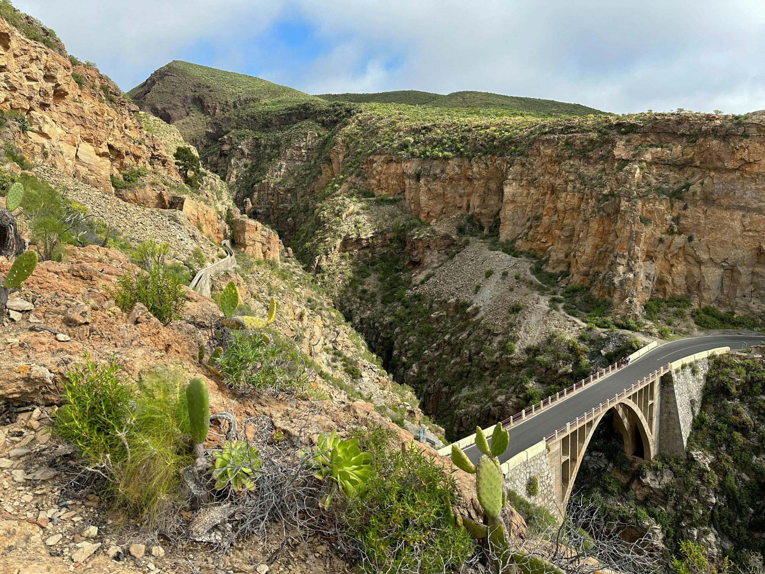
Before you reach the first big bend in the road, the trail branches off to the left of the road. For a short while, the trail runs parallel below the road. Then it goes downhill for a long time towards the Barranco de La Orchilla. Finally, you reach the edge of the barranco. On serpentine paths, you first descend into the gorge and then climb up again on the other side. You can enjoy impressive views of the deep gorge on both paths. At the top, you will reach a road that will take you around to the right and uphill in a short time to the starting point of TF-28 at Barranco de La Orchilla.
Hiking trail through the Barranco de La Orchilla
And finally
I hope you enjoyed this really varied circular walk around the Barranco de La Orchilla and to Montaña Colorada. The length and route can also be wonderfully combined with other hiking trails in the vicinity. Whatever you decide, I wish you lots of fun on all your hikes,
Dagmar from SiebenInseln
Thank you for reading!
If you've found my hiking guides on SiebenInseln helpful for your Canary Islands adventures, please consider leaving a small tip. Your support is greatly appreciated and helps cover the costs of maintaining this blog.