The Canal de Chabuco and the Canal de Catalanes more or less merge. Below the Casas de Cumbre in the Anaga is the Galería Chabuco. From there on, the canal is called Canal de Chabuco. Below Caserío la Galeria, it merges into the Canal de Catalanes. If you keep following the canal, you will eventually come down to Santa Cruz de Tenerife. I have made two circular walks out of these two canal walks.
Map
Tunnel crossing on the Canal de Catalanes
If you have plenty of time and are in good shape, you can of course combine the two hikes into one big round trip. On the first round tour, you start at the Casas de Cumbre in the Anaga and hike almost the entire Canal de Chabuco. On the second round trip, you continue a little further along the Canal de Chabuco before continuing along the Canal de Catalanes.
Hiker on the canal path
Hike Canal de Catalanes
As you can see from the pictures, the weather was quite sunny when we walked along the Canal de Catalanes. In general, it is quite safe to walk and also secured with ropes in many exposed places. Nevertheless, it was quite wet and a bit slippery on the canal at the beginning of 2023 after a lot of rain in the Anaga. So be careful in which weather you do this tour. The hike starts close to the Anaga High Road below the Mirador Los Catalanes on the road to Los Catalanes.
For a short while you will hike downhill along the trail you used to return from the Chabuco canal hike. At the point where the Canal de Chabuco crosses your path, go down to the right and continue along the canal, which is called Chabuco for a while and then Canal de Catalanes. Beautiful views and dark tunnels await you. Finally, you can return to the starting point on a long ascent via the village of Los Catalanes.
Track of the Canal de Chabuco (red green) and Canal de Catalanes (green) walks
General information about the Canal de Catalanes hike
Starting point and approach
The starting point of the hike is the road to Los Catalanes below the Anaga mountain road TF-12 – GPS: 28.532120, -16.247627.
Arrival with car
You can either come from Las Mercedes or via San Andrés on the TF-12 of the Anaga mountain road. At the Casas de la Cumbre, turn onto the road towards Los Catalanes. After a short while, the road bends sharply to the right. Straight ahead, a road that merges with the hiking trail runs past a few houses. Here you can easily park at the side of the road.
Arrival with bus
The Titsa bus lines 076 and 077 stop directly at Casas de la Cumbre. Details of how to get there and other connections can be found on the Titsa website. From there you can get to the starting point of the hike in a short time.
Time
I don’t like to give general times for hiking tours because the times are very individual. We needed less than 4.5 hours for the entire route with a long rest.
Article summary and large selection of GPS hiking tracks
Sign up for my newsletter now and get exclusive access to my collected GPS tracks as well as all the brief information about my articles.
The difference in altitude is about 520 metres and the route is just under 12 kilometres long.
Requirements
The ascent and descent to the canal is on fairly good footpaths, although they were a little muddy in early February 2023 due to the heavy rains. The canal path is generally safe and secured with ropes in unsafe places. Nevertheless, in early February 2023, the trail was heavily overgrown in places, so you had to watch where exactly you were stepping. The canal paths were also a little muddy in places and therefore slippery. So the utmost attention is required. A head for heights and surefootedness are absolutely necessary for this hike. It is also important to pay attention to the weather and not to go on the tour in rain and storms. Don’t forget a headlamp or torch for the tunnel passages.
Refreshment stops
There are no refreshment stops along the way. Therefore, please take sufficient water and, if necessary, food with you for the hike.
Hiking signs in the direction of Catalanes
Variants
Of course, you can combine this hike with the Canal de Chabuco hike. If you arrive by bus, you can also continue to follow the canal until you reach Santa Cruz de Tenerife, so that you do not have to climb any more.
View towards Caserío la Galería and up to the Anaga ridge
Hike Canal de Catalanes
Los Catalanes Road to Canal de Catalanes section
Below the Mirador Los Catalanes, a road branches off to the left at the first sharp bend to the right. It passes a few houses and then immediately joins a hiking trail. I described this path as a return route in the article Hiking Canal de Chabuco. Now you go down again in the opposite direction. It leads you steeply downhill on a ridge path. At some point you will reach the end of the ridge path. On your right you will see some farmsteads.
View from the hiking trail to the Canal de Catalanes over the mountain ranges of the Anaga Mountains
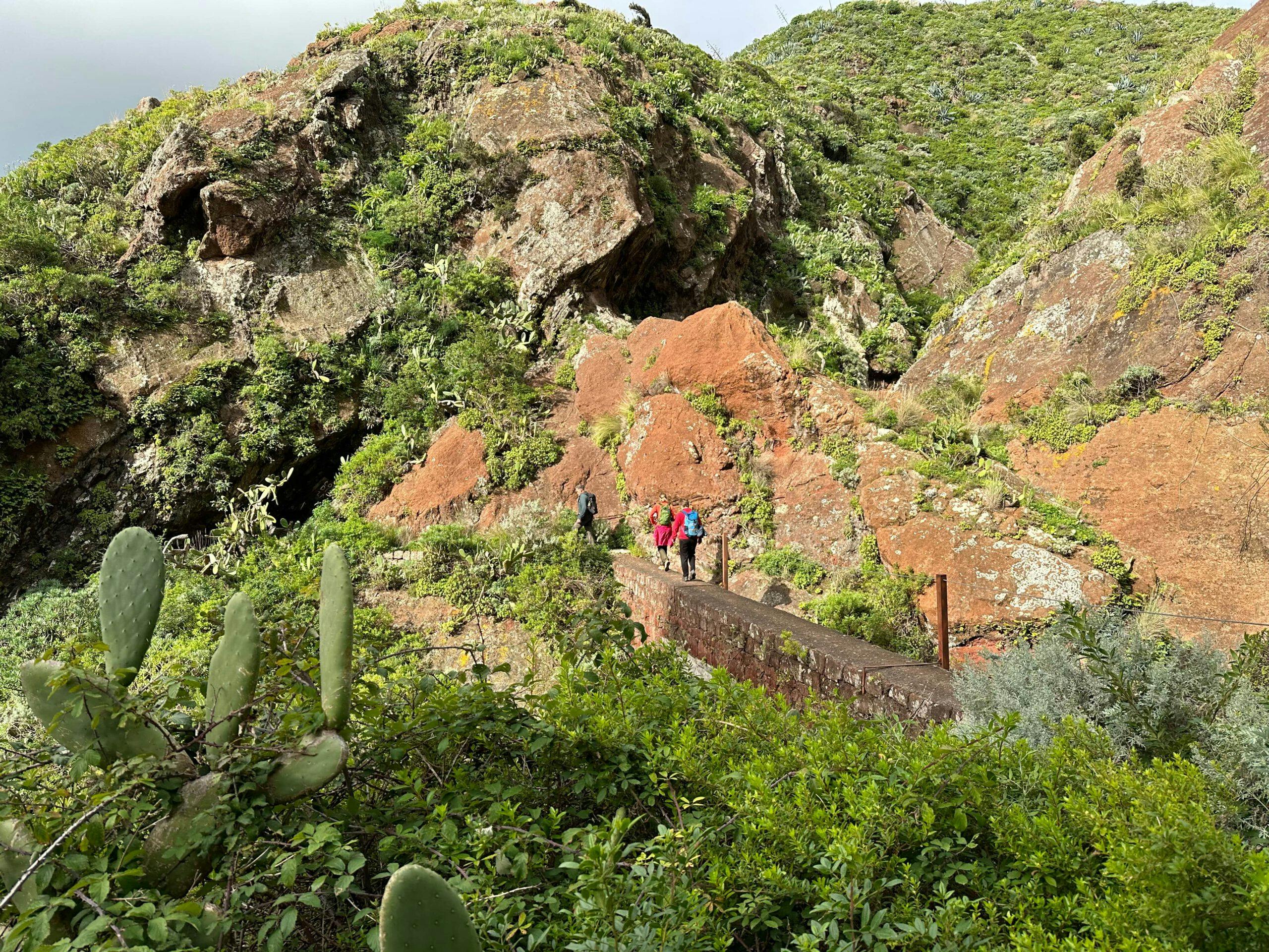
The road from there runs downhill to the small village of Caserío la Galería. However, you walk down the slope to the left into a ravine. You follow the course of the gorge for a short time. Then the trail takes you to the left side of the valley. Walk along this side of the valley for a while. Then you will see a bridge and the Canal de Chabuco on your right. A small path on the right side of the path leads downhill to the canal, so that you can resume the canal hike here.
Hikers on the way down to the Canal de Catalanes entrance
Section Canal de Chabuco to 1st tunnel Canal de Catalanes
You walk across a bridge over the Barranco El Hoyo. Then you hike for quite a while, first upwards and then gently up and down along the mountainside on the canal, which is still called Canal de Chabuco here. Magnificent views are guaranteed, but be careful. Surefootedness is required here. Finally, you will come to the small hamlet of Caserío la Galería along the course of the canal. Follow the canal past the edge of the hamlet and cross the Barranco de Valle Grande on a bridge.
Article summary and large selection of GPS hiking tracks
Sign up for my newsletter now and get exclusive access to my collected GPS tracks as well as all the brief information about my articles.
On your right is the Galería los Catalanes and from here on the canal is also called Canal de Catalanes. After a short while you will cross another small bridge. Then you continue to walk along the Canal de Catalanes on the slope side for a very long time. You will also cross some mountain ridges. You cross a small gorge and hike uphill. Now you reach the first tunnel on the Canal de Catalanes, which is relatively long. In contrast to the Canal de Chabuco hike with 9 tunnels, you will only see 3 tunnels on this hike, but they are longer.
Tunnel entrance on the Canal de Catalanes
Route section 1. tunnel Canal de Catalanes to 2. junction Valle Grande
After passing through the tunnel, continue to the right along the canal and downhill a little. Then cross another bridge over the Barranco Hoya de las Colmenas. On the other side, the path continues slightly uphill along the slope. You walk over a ridge and down the slope again. At the bottom you cross the gorge to continue along the slope. After overcoming another ridge, you reach tunnel 2 on the Canal de Catalanes.
The way on does not always lead through tunnels. Here you continue between the rocks on the canal path.
This is also a little longer, but not as long as tunnel 1 on this hike. Shortly afterwards, you will come to a prominent ridge. From there, a path leads downhill to the left to the hamlet of Valle Grande. However, you continue straight ahead along the canal. After a while, there is another turnoff to Valle Grande on the left. Ignore this one as well and continue straight ahead along the canal.
Hikers on the Canal Trail
Route section 2. junction Valle Grande to Gollada La Fortaleza
View of Los Catalanes from the hiking trail
After a short while, you will reach tunnel 3 of the Canal de Catalanes walk. This is the longest and last tunnel of the entire canal hike. Afterwards, you will walk along the canal for a while and cross other small gorges, including the small Hoya El Corral gorge. Finally, the canal crosses the hiking trail that goes up from Santa Cruz de Tenerife to Pico del Inglés in the Barranco de Valle Seco.
While the canal continues to descend towards Santa Cruz de Tenerife, you hike uphill from here around to the right on the PR TF-2 hiking trail. The trail leads uphill on one side of the slope and then on the other, and you can’t miss it. After a steep ascent on the left side of the slope, you finally reach a junction at Gollada La Fortaleza (680m). Take the PR TF-2 to the left to continue to Pico del Inglés. However, you follow the hiking trail PRA 43 around to the right in the direction of Los Catalanes.
Route section Gollada La Fortaleza to starting point Hike
Hiking trail between Los Catalanes and Casas del Cumbre
You continue to hike slightly uphill along green meadows and fields (at least at the beginning of 2023) at the foot of a mountain range. After a while, you cross the Gollada La Cancela (690m). The path then descends slightly along the mountain slope towards Los Catalanes. Finally, you will reach a road that will take you down to the village.
Hiking trail uphill towards Los Catalanes and Casas del Cumbre
At the point where the road meets the main road, you could turn right into the village of Los Catalanes. To return to the starting point, turn left. Now you just have to walk uphill for quite a while on this road with hardly any traffic. Eventually, the road will take you right back to the starting point of your hike.
And finally
I hope you enjoyed what I thought was a very exciting and unusual hike in the Anaga across the Canal de Catalanes. But if you do this hike, please pay close attention to the weather and be careful overall. Together with the Canal de Chabuco walk, you can also make it quite a big canal walk. Whatever you decide, I hope you enjoy all your walks,
Dagmar from SiebenInseln
Thank you for reading!
If you've found my hiking guides on SiebenInseln helpful for your Canary Islands adventures, please consider leaving a small tip. Your support is greatly appreciated and helps cover the costs of maintaining this blog.