The Canal de Chabuco and the Canal de Catalanes more or less merge. Below the Casas de Cumbre in the Anaga is the Galería Chabuco. From there on, the canal is called Canal de Chabuco. Below Caserío la Galeria, it merges into the Canal de Catalanes. If you keep following the canal, you will eventually come down to Santa Cruz de Tenerife. I have made two circular walks out of these two canal walks.
Map
If you have plenty of time and are in good shape, you can of course combine the two hikes into one big round trip. On the first round tour, you start at the Casas de Cumbre in the Anaga and hike almost the entire Canal de Chabuco. On the second round trip, you continue a little further along the Canal de Chabuco before continuing along the Canal de Catalanes.
In some places, ropes are stretched along the canal path for people to hold on to
Canal hike Canal de Chabuco
As you can see from the pictures, the weather was a bit grey and wet when we walked along the Canal de Chabuco. In general, it is quite safe to walk and also secured with ropes in many exposed places. Nevertheless, it was quite wet and a bit slippery on the canal at the beginning of 2023 after a lot of rain in the Anaga. So be careful in which weather you do this tour.
The hike starts on the Anaga mountain road at Casas de Cumbre. For a short while you walk down the trail towards Valle Brosque. At the point where the Canal de Chabuco crosses your trail, hike up to the right and continue along the canal. Beautiful views and dark tunnels await you. Finally, you can return to the starting point on a steep ascent path.
Canal de Chabuco Circuit Track
General information about the Canal de Chabuco hike
Starting point and approach
The starting point of the hike is the Anaga High Road TF-12 diagonally opposite the Ermita de Nuestra Señora de Guadalupe at approx. 820 metres altitude.
Approach in car
You can either come from Las Mercedes or via San Andrés on the TF-12 of the Anaga mountain road. At the starting point, Casas de la Cumbre, there is a place to park your car at the side of the road.
Approach in bus
The Titsa bus lines 076 and 077 stop directly at Casas de la Cumbre. Details on how to get there and other connections can be found on the Titsa homepage.
Article summary and large selection of GPS hiking tracks
Sign up for my newsletter now and get exclusive access to my collected GPS tracks as well as all the brief information about my articles.
I don’t like to give general times for hiking tours, because the times are very individual. We needed a little less than 5 hours for the entire route.
Altitude profile of the Canal de Chabuco circular walk
Altitude difference and route length
The difference in altitude is about 520 metres and the route is just under 10 kilometres long.
Requirements
The ascent and descent to the canal is on good footpaths, although they were a little muddy at the beginning of February 2023 due to heavy rainfall. The canal trail is generally safe and secured with ropes in unsafe places. Nevertheless, in early February 2023, the path was heavily overgrown in places, so you had to watch where exactly you were stepping. The canal paths were also a little muddy in places and therefore slippery. So the utmost attention is required. A head for heights and surefootedness are absolutely necessary for this hike. It is also important to pay attention to the weather and not to go on the tour in rain and storms. Don’t forget a headlamp or torch for the tunnel passages.
Refreshment stops
There are no refreshment stops along the way. Therefore, please take enough water and, if necessary, food with you for the hike.
Canal de Chabuco circular route (yellow), Canal de Catalanes circular route (green)
Variants
You can of course combine this hike with the second part of the Canal de Catalanes hike. If you arrive by bus, you can also continue to follow the canal until you reach Santa Cruz de Tenerife, so that you don’t have to climb any more.
The PR-TF 3 trail branches off at an information board at TF-12, Casas de la Cumbre. From up here you have a magnificent view of the coast and the island’s capital, Santa Cruz de Tenerife. After a short while, you will pass a house on your left and reach a road. Follow this to the right. After about 100 metres, however, the footpath branches off again on the left side of the road. You walk downhill on a steep path through the bush forest and thus shorten the road, which you meet again a little later. Up here, someone has set up two chairs that invite you to linger in good weather.
Hiking trail through the tunnel
Once again you cross the road. Then the steep path descends steeply over a wooded ridge. The forest gradually thins out. You quickly lose height on the steep descent. The trail runs along one side of the slope for a while and then crosses the Barranco de los Berros. From there, the path continues down the slope towards Valle Brosque. However, you do not descend, but before the crossing, you climb up the right side of the slope to the Canal de Chabuco.
Article summary and large selection of GPS hiking tracks
Sign up for my newsletter now and get exclusive access to my collected GPS tracks as well as all the brief information about my articles.
View from Canal de Chabuco down into the gorges of Anaga
Section Canal de Chabuco to behind Tunnel 3
You are now at about 500 metres altitude and follow the canal, which you cannot miss, further and further along. From time to time it is a little overgrown, but still easy to hike (as of February 2023). After a short while, you come to the first tunnel (Tunnel 1). The tunnels on the Canal de Chabuco are mostly quite high, but very narrow. But they are wide enough to walk through easily. You walk uphill for quite a while, high above and parallel to the PR-TF 3 trail.
Small tunnels take you across the Canal de Chabuco
On the ridge, the path turns west along the slope. Two more tunnels (tunnels 2 and 3) follow at a short distance. The second tunnel (tunnel 3) is a little longer than the previous two. From the canal you can enjoy beautiful views – hopefully in better weather than I had – all the way to Santa Cruz and over the heights of the Anaga Mountains. You hike gently up and down the slopes of the mountains.
Rock crossing at the Canal de Chabuco - tunnel is buried, so the descent over the ridge is a little steep.
Section behind tunnel 3 to after tunnel 9
Finally you reach a ridge. You cannot cross it through the tunnel there, as it is filled in (tunnel number 4). Here you have to climb up the ridge in a few metres and down again on the other side. Then follow the canal slightly downhill on the other side of the slope. After quite a while, tunnel number 5 follows, which is quite short. Soon after, there is a very long tunnel number 6. On the right side of the slope, high above Valle Crispin, there is tunnel number 7. You walk slightly downhill and then cross the Barranco Valle Crispin on a bridge secured with a steel rope. On the other side of the slope you hike slightly uphill again.
Hikers on the path over your ridge - a steep path leads up to the right. The canal path continues straight ahead.
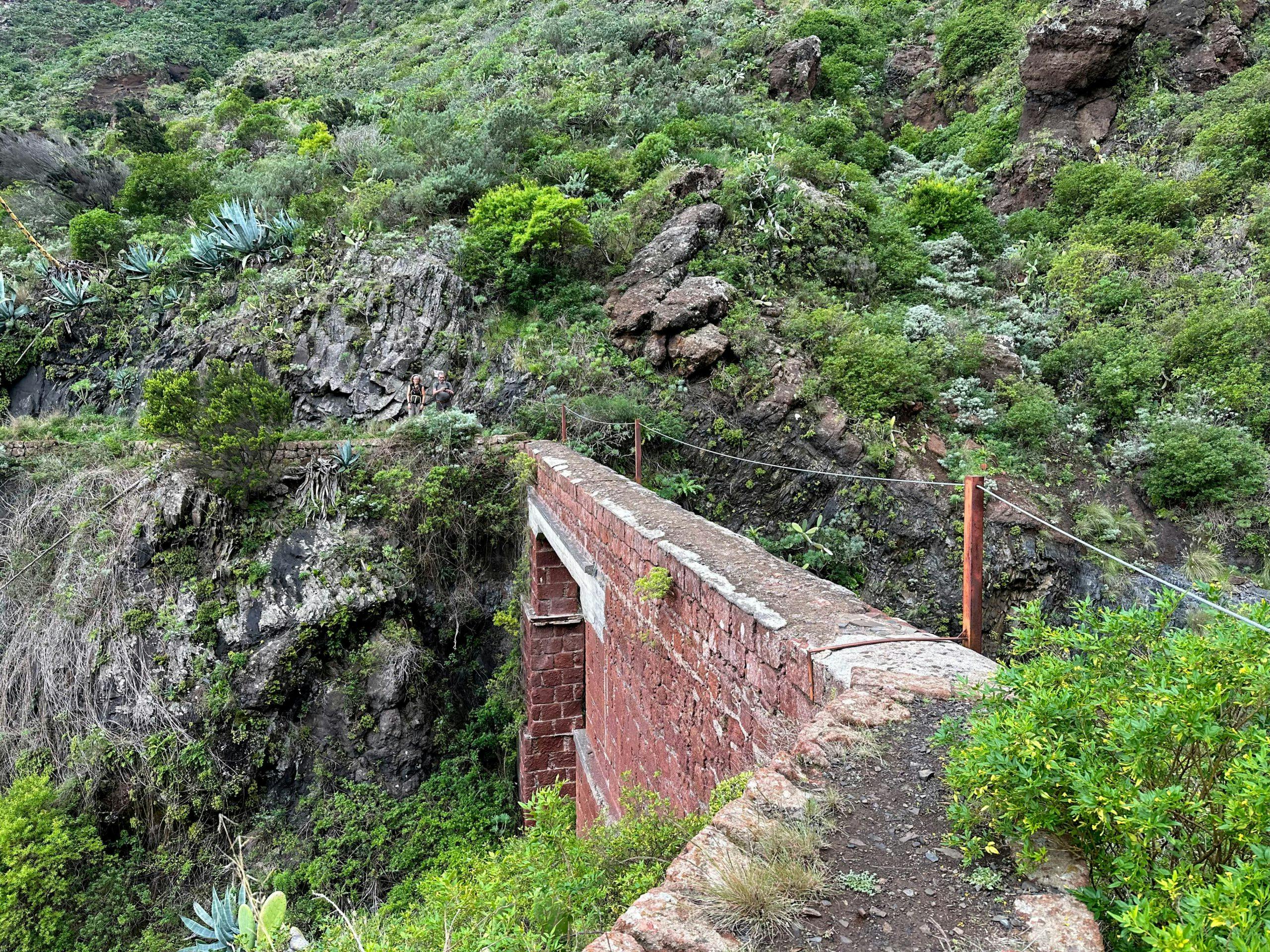
The path continues to offer fantastic views. After tunnel number 8, the path continues slightly uphill on the slope. On the ridge, a narrow steep path branches off to the right uphill. However, you hike straight ahead once again slightly downhill on the slope. Now you come to tunnel number 9, the last tunnel of this loop. Shortly after, the path branches off. Turn left and go down to a bridge. There the Canal de Chabuco continues. To complete the round tour, however, leave the canal path here and continue straight ahead on the right side of the slope on the parallel path.
View of the canal path in front of you, which runs around the individual ravines along the slopes of the Anaga Mountains - background a bridge to be crossed.
Section after tunnel 9 to the starting point Casas de la Cumbre
The small footpath leads you straight along the right side of the slope for a while. Then it takes you down into a small ravine. You follow the course of the gorge for a short while. Then the trail goes steeply up the slope to the left. On the left below you, you will see some farms. The road from there goes downhill to the small village of Caserío la Galería. You will get there in the second part of the hike.
Bridge crosses a barranco - from here you leave the canal path for the first round hike and hike up to the starting point. If you want to do the full circuit, continue along the canal over the bridge here
Now you will continue to climb uphill on the ridge path for a long time and very steeply. You continue to follow the ridge until you reach a road at an altitude of 700 metres. Follow this road uphill to the right for a short while. Depending on where you parked, you will have to walk along the TF-12 for a while until you reach the starting point at the end of the small village.
Hiking trail through the barranco with crossing of the slopes just above the Canal Chabuco - hiking trail up to Casas de la Cumbre
And finally
I hope you enjoyed what I thought was a very exciting and unusual hike in the Anaga across the Canal de Chabuco. But if you do this walk, please pay close attention to the weather and be careful overall. You can find the second part of the impressive canal hike here: Hike along the Canal de Catalanes. I wish you much joy on all your hikes,
Dagmar from Siebeninseln
Thank you for reading!
If you've found my hiking guides on SiebenInseln helpful for your Canary Islands adventures, please consider leaving a small tip. Your support is greatly appreciated and helps cover the costs of maintaining this blog.