Las Lajas – Picnic Area and Great Starting Point for Hikes
The picnic area, Zona Recreativa Las Lajas, is located in the southwestern part of the island of Tenerife at an altitude of 2,100 metres above sea level along the TF-21. Due to this altitude, temperatures can vary significantly between seasons and even between day and night. The area is predominantly home to Canary Island pine trees, which mix with summit shrubs typical of the region, such as gorse. In terms of fauna, hikers will frequently encounter great spotted woodpeckers, Teide finches, or the Canary Island lizard.
Map

Rest area Zona Recreativa de Las Lajas
The Zona Recreativa Las Lajas is a popular spot for locals and tourists alike to take a break, enjoy the fresh mountain air, and experience the tranquillity of nature. Las Lajas is particularly well-known for its well-equipped picnic areas with barbecue facilities, ideal for a leisurely outdoor meal. Overnight stays are also possible here with prior booking. Several hiking trails lead from Las Lajas into the surrounding forests. The picnic area itself is especially appreciated for its relaxed atmosphere and stunning views of Tenerife’s southern coast.

There are several gorges to cross along the slopes on this circular walk
Hiking through Wild Gorges around and over the Montaña de Las Lajas
From Las Lajas, you can ascend towards the Cañadas. Under „Variants,“ I will introduce you to a few hiking routes. However, the hike described here takes you down the southwestern slopes of Tenerife into various gorges. Along the way, you will encounter many junctions, providing plenty of variation to suit every taste and level of fitness.

View from the hiking trail below the Montaña de Las Lajas up to the Cañadas
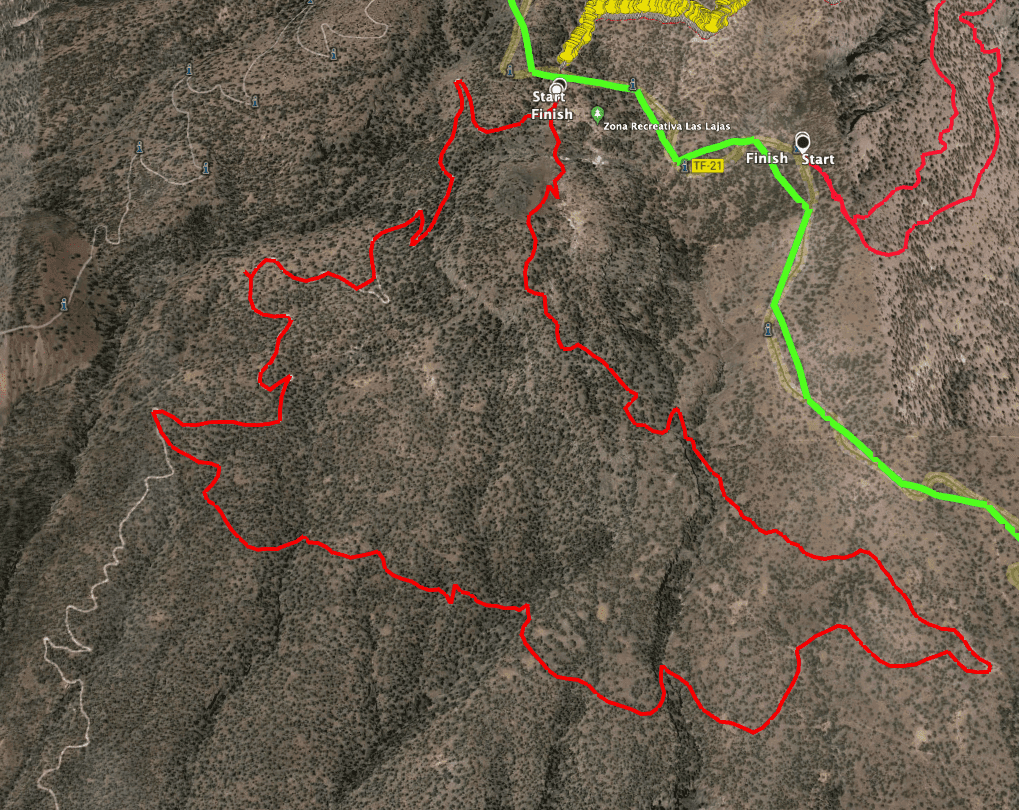
Here, I will describe a circular hike that initially takes you downwards from below Las Lajas. You will pass a junction leading down to La Quinta via the Casas de Teresme. However, you will first hike around Montaña de Las Lajas, crossing from one gorge to the next. Later, the route takes you back over more gorges. The path may become a bit rough in places, but eventually, you will reach the summit of Montaña de Las Lajas before returning to the Las Lajas picnic area.

Track of the circular hike Las Lajas
General Information about the Las Lajas Circular Hike
Starting Point and Directions
The starting point for the hike is the Zona Recreativa Las Lajas picnic area on the TF-21, between Vilaflor and Boca Tauce.
Access by Car
From the coast, you can drive via Arona or Granadilla de Abona to Vilaflor. From there, continue upwards towards Teide. Some time before reaching Boca Tauce, you will find the well-signposted Zona Recreativa Las Lajas picnic area on the left-hand side. Access is via a short unpaved forest road. There are ample parking spaces at the picnic area.
Access by bus
Only the Titsa bus line number 342 goes up into the Cañadas. It stops directly at the Las Lajas picnic area. For more information, visit the Titsa website. Article summary and large selection of GPS hiking tracks
Sign up for my newsletter now and get exclusive access to my collected GPS tracks as well as all the brief information about my articles.
Sign up nowTime
I am reluctant to give general time estimates for hikes as they vary greatly depending on the individual. We took about 4.5 hours for this leisurely round, including breaks.

Elevation profile of the Las Lajas hike
Elevation Gain and Distance
The elevation gain is approximately 460 metres, and the route is 12.5 kilometres long.
Difficulty
Most of the hike follows good hiking or dirt roads. Occasionally, the path crosses more challenging terrain and small trails. However, I also provide tips on how to avoid these sections. A good level of fitness is required.
Refreshment
There are no refreshment stops along the entire route, so be sure to bring enough water and snacks.

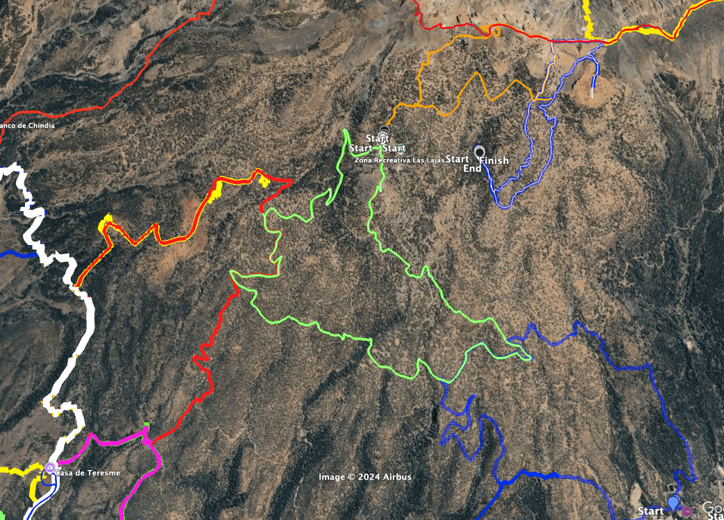
The track of the Las Lajas hike (green centre) and neighbouring tracks: Villaflor circular hike (blue bottom right), Cresta Canñadas (red top), Sombrero de Chasna (blue top right), Casas de Teresme (red, white left)
Variants
The hike can easily be combined with other nearby walks, as there are several alternative paths branching off the main route. I will cover this later in the article, as I have already completed some of the hikes but haven’t yet written them up.
On SiebenInseln, you’ll find other nearby hikes such as:

Hiking trail through pine forests below the Montaña de Las Lajas
Article summary and large selection of GPS hiking tracks
Sign up for my newsletter now and get exclusive access to my collected GPS tracks as well as all the brief information about my articles.
Sign up nowCircular Hike Montaña de Las Lajas
Section: Zona Recreativa Las Lajas to the Junction off the Main Trail
Your hike begins at the Zona Recreativa Las Lajas picnic area. From there, follow the main path away from the road, crossing the entire picnic area. After passing the last building, take the right-hand trail (PR-TF 71). This path takes you downhill. You will cross a small gorge and continue descending towards the Barranco de Padilla. Before reaching the barranco, follow a wide switchback and head in the other direction. Then, continue downhill through the pine forest.

Hiking signposts at the Zone Recreativa to the PR- TF- 71 hiking trail and the turn-off to the Casas de Teresme
After some time, you will reach a junction. Here, the PR-TF 71 branches off to the right, descending through a barranco. It continues downhill to the Casas de Teresme and La Quinta. For the Las Lajas circular hike, however, continue straight ahead, descending further. Eventually, you will come to another junction. Going straight, the trail continues downhill towards the Galería de Nuestra Señora del Rosario and further towards Casas Teresme, another beautiful large circular hike. 
Hiker on the hiking trail below Las Lajas down into a ravine
Section: From the Junction to after the Barranco del Rey
For the Las Lajas round, turn left at the junction. You will initially hike through sparse pine forest on a wide path, which gradually narrows as it leads down into a gorge (the Barranco los Lagos). For a while, the trail may become unclear, but it continues heading east. Shortly before crossing the Barranco del Agua, the path becomes more visible again. You will continue hiking up and down along the hillside.

Hiking trail below Las Lajas with a small gorge crossing
You can enjoy lovely views of the southwestern coast of Tenerife along the way. As you hike, you will cross another gorge, the Barranquillo del Lomo del Tabeibo. The next gorge is the Barranco Seco, which is particularly deep and impressive. On the other side of the gorge, a path branches off to the right, leading down to Trevejos. However, you will continue straight ahead and cross the Barranco del Rey. After crossing the Barranco del Rey, another path branches off to the right, leading to Vilaflor. I have yet to publish this lovely route on SiebenInseln. You could also ascend here to shorten and simplify the round.

Hiking on the track
Section: After the Barranco del Rey to the Las Lajas Picnic Area
Otherwise, continue along the wide dirt road, more or less maintaining your altitude, heading east. Just before reaching the TF-21 above Vilaflor, turn left off the main path. The trail on the bush-covered plateau becomes somewhat unclear again, marked only by stone cairns. If you want to avoid this, ascend earlier after crossing the Barranco del Rey. You will eventually rejoin this path at the Barranco del Rey.

Hiking trail up towards Montaña de Las Lajas
Cross the Barranco del Rey and then, after traversing the Barranco Seco, ascend further towards Montaña de Las Lajas. Now, the climb becomes steeper, but you will be rewarded with magnificent views. Finally, the trail will bring you close to the summit of Montaña de Las Lajas. Skirt around the summit to the left, and the path will lead you back down to the Las Lajas picnic area.

Hiking trail on the Montaña de Las Lajas shortly before the descent to the rest area
And finally
I hope you enjoyed this circular hike around Montaña de Las Lajas. I admit that it can be a bit challenging in places, but you don’t have to follow my exact track and can avoid the rougher sections. Whatever you choose, I wish you much joy on all your hikes.
Dagmar from Siebeninseln


