Mirador Minas de San José is on the Carretera de las Cañadas del Teide (TF-21). This is the road that runs along the entire caldera below Mount Teide. The Mirador consists of two large interconnected car parks. When you get out of the car, you can walk across a large plateau of white sand. The path goes slightly uphill and after about 100 metres you come to a drop-off. From here you have a beautiful view of the entire caldera and the surrounding cañadas.
Map
Parking at Mirador Minas de San José
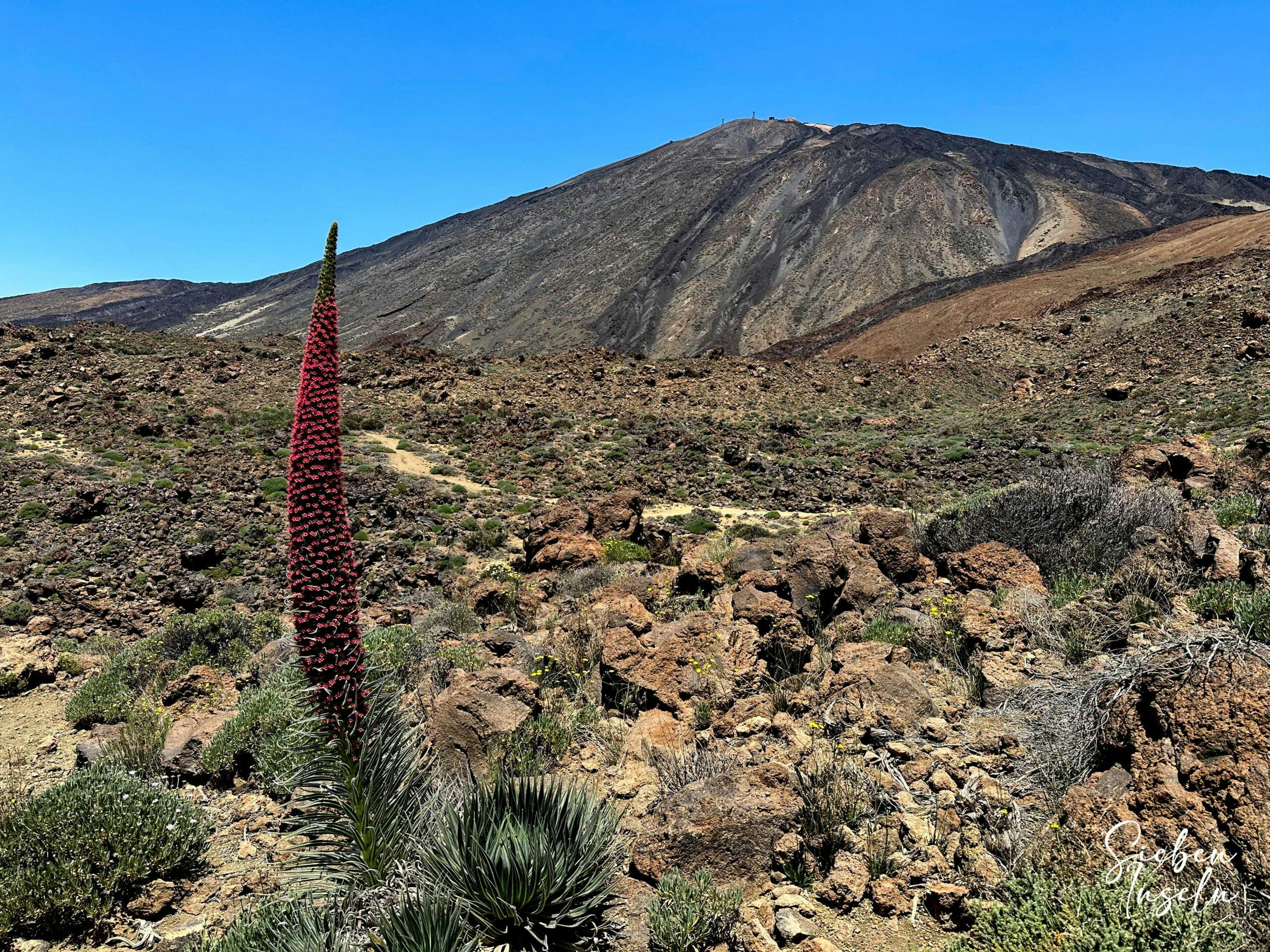
Even if you are not a hiker, you can walk down towards the caldera and enjoy the beautiful bizarre landscape. Hiking here is particularly attractive in the months of May and June. This is when you can admire the magnificent large endemic bright red Tajinasten. Read more about the Tajinaste here. And if you are very lucky, you might even spot some of the few blue Tajinasten nearby and on your hike.
Tajinasten on the Cañada slopes - hiking trail S-4
Great circular hike from Mirador Minas de San José around the caldera
You start the big circular hike from the Mirador Minas de San José. With its 24 kilometres at an altitude of over 2000 metres, it is quite a challenge. But if you are fit enough, you will enjoy it. First you hike 5 kilometres downhill through a barren bush landscape, through small gorges and valleys. Then you reach the large Siete Cañadas road. On this road you walk for quite a while below the impressive Cañadas heights.
Rare blue tajinaste by the wayside (found May, June each year)
Finally, you take the former Sanatorio path past a lot of obsidian back towards Teide. You have the Teide in view for most of the hike. When you have almost reached the cable car station, turn right. For the last 6 kilometres you hike up and down more or less parallel to the road and the Teide. A last hard climb brings you back to the Mirador Minas de San José.
Track of the hike Minas de San José - Great Caldera Circuit
General information about the circular hike Mirador Minas de San José
Starting point and route
The starting point of the hike is the Mirador Minas de San José on the TF-21 between the Parador and El Portillo.
Approach by car
From whichever side of the island you drive up towards the Teide, you will eventually reach the Carretera de las Cañadas del Teide TF-21, which leads directly past the Mirador Minas de San José. Compared to other car parks in the Cañadas, you will always find enough space in this car park. This large car park actually consists of two connected car parks.
Approach by bus
The Titsa bus line 348 runs along the TF-21 and the nearest bus stop, El Recodo, is 700 metres from Mirador Minas de San José. However, the buses only run twice a day. Therefore, you have to check the Titsa homepage beforehand.
Time
I don’t like to give general times for hiking tours, as the times are very individual. I needed exactly 6 hours for the round hike with a break and photo stops.
Article summary and large selection of GPS hiking tracks
Sign up for my newsletter now and get exclusive access to my collected GPS tracks as well as all the brief information about my articles.
Altitude profile of the hike Minas de San José - Great Caldera Circuit
Altitude difference and track length
The difference in altitude is approx. 600 metres and the route is 24 kilometres long.
Requirements
You hike the entire time on good and signposted hiking trails. There are neither exposed nor dangerous places on this circular tour. I have only classified it as difficult because of the length of 24 kilometres. This is because you need a good level of fitness for this route at altitude. If you only do parts of the hike, it is classified as easy.
Refreshments and sun protection
There are no refreshment stops along the entire route. Therefore, please take sufficient water and, if necessary, food with you for the hike. Because of the strong sun, please do not forget sun protection.
Track of the hike Minas de San José - Great Caldera Round (green) and neighbouring tracks Cumbre, Siete Cañadas
Variants
This hike can also be divided into sections if you don’t want to do the whole loop. You could walk down Sendero 30 to Siete Cañadas Sendero 4 and then walk back. You can also walk from Sendero 4 to El Portillo and then take the bus back to Mirador Minas de San José.
Route section Mirador Minas de San José to hiking trail S-4 (Siete Cañadas)
You start your hike at Mirador de San José on the northern part of the car park. You will return on the southern part of the car park. Both parts are connected by a narrow path parallel to the TF-21. At the end of the northern car park, signposted trail S-39 begins, which will take you slightly downhill over white sand dunes on a path partly marked with stones on the sides. For a while, the trail runs parallel below the TF-21, then turns downhill towards the east.
Hiking trail S 30 below Mirador Minas de San José with Teide view
You walk through a lonely sand and bush landscape. And you cross several valleys on your way down. Finally, you walk downhill along a slope, cross a large gully and walk down again on the other side into a long white sandy valley. Across this valley, the path leads you into a large sandy field, which you cross. At the end of the sandy path, you will reach the hiking trail S-4 (Siete Cañadas). This runs from El Portillo to the Parador.
View from the hiking trail below Mirador Minas de San José towards hiking trail Siete Cañadas
Section of trail S-4 (Siete Cañadas) to Guajara ascent trail
If after the first 5 kilometres you don’t want to do the big loop, you can turn left to El Portillo or go back. For the big loop, continue to the right. You follow the S-4 road for a long time, which leads you below the Cañadas mountain towards the Parador. On the right, you can enjoy magnificent views of the Teide. To the left, you can admire the individual rocks of the Cañadas.
Article summary and large selection of GPS hiking tracks
Sign up for my newsletter now and get exclusive access to my collected GPS tracks as well as all the brief information about my articles.
If you hike in the months of April, May or June, there is a good chance that you will see many large red tajinas. In the other months, unfortunately, you will only see their carcasses. After walking past the impressive rock Roque de la Grieta, you can see Guajara in front of you on the left. After a while, the ascent path goes up to the saddle between Guajara and Roque de la Grieta on the left.
Hiking trail S-4 Siete Cañadas with a view of the Cumbre rocks
Section of the Guajara ascent trail to the S-39 Mirador Minas de San José trail junction
Continue straight ahead for a short while. A short time later, at the next junction, leave the S-4 and turn right onto the S-16. The S-4 continues straight ahead to the Parador. The S-16 used to be called Sanatorio, because there were ruins of a sanatorium along the way. This was supposed to be built for lung patients. Now all the buildings have been demolished. You can read more about this here on the short hike through the caldera. However, you will still be able to marvel at the black obsidian along the way.
Hiking trail S-16 direction Teide
You follow the wide hiking trail S-16 uphill towards Teide for a long time. After a while, the path leads you in a wide arc around the former sanatorium area. Then you cross a large ridge, hike briefly through a valley, and then climb up the left side of the slope. Then you walk straight towards the TF-21 and you can already see the valley station of the cable car to Teide above you. When you see the white heights of the Majúa heights on your left, you will come to another junction. The S-39 to Mirador Minas de San José branches off to the right.
Obsidian by the wayside
Route section Branch off hiking trail S-39 Mirador Minas de San José to car park Montaña Blanca
Now you are already back at almost 2300 metres altitude. And there are still 6 kilometres to the finish Mirador Minas de San José. This last part was the most strenuous part of the hike for me. Perhaps I was already a little tired. However, the scenery is impressive and if you are there at the right time, you can find blue tajinas as well as red ones. The S-39 first leads you downhill for quite a while, then you walk along a slope towards the north, still slightly downhill.
Hiking junction before Teide junction S-39 from S-16
Finally, you will climb quite steeply uphill again. Near the Mirador El Tabonal Negro you will reach the TF-21, where you will cross a ridge on the hiking trail. Then you walk for a while below and parallel to the TF-21 along a lava slope. Finally, you have to cross another ridge. After a steep climb, you will be back on the TF-21, this time at the Montaña Blanca car park.
Trail S-39 leads past the road - Montaña Blanca junction
Route section Montaña Blanca car park to Mirador Minas de San José
Hiking junction at Mirador Minas de San José – ascent path before the end of the hikeFrom here it is another 3 kilometres to the starting point, the Mirador Minas de San José. Again, the trail turns away from the road down into a valley. You walk downhill along the slope for a very long time. Finally, the path turns north. You cross some small ravines and heights up and down. Then you come to a road that runs down from the TF-21. Cross this and continue downhill on the right side of a ravine, then the path crosses the ravine.
Hiking trail Sendero 39 towards Minas de San José
You will reach a wide valley (Valle de las Piedras Arrancadas – Valley of the Broken Stones). Here the path continues slightly uphill. Then you come to a high white precipice. There you have to climb steeply again. However, the path is very comfortably paved with stones to allow visitors to the mirador to walk into the valley. After this last steep climb, you will stand at the top of the wide sandy area of the Mirador Minas de San José. Now (fortunately) it is not far to the starting point and your car.
Hiking junction at Mirador Minas de San José - ascent path before the end of the hike
And finally
I hope you enjoyed this rather large circular hike in the caldera of Tenerife. If you want to do this hike and you have the time to do it, I can only recommend that you do it from the end of April to June to see the beautiful tajinas. I hope you enjoy all your hikes,
Dagmar from Siebeninseln
Thank you for reading!
If you've found my hiking guides on SiebenInseln helpful for your Canary Islands adventures, please consider leaving a small tip. Your support is greatly appreciated and helps cover the costs of maintaining this blog.