11/30/2023 (updated: 10/20/2024) | 14min Reading time
Varied circular hike via Valle de Arriba
DifficultyModerate
IslandTenerife
Altitude460m - 570m
Distance15km - 17km
Circular hike
Valle de Arriba in Santiago del Teide
The small district of Valle de Arriba belongs to the district town of Santiago del Teide, which is only 2 kilometres away. Here the name „High Valley“ refers to the hamlet’s location at the highest point of the Santiago Valley at an altitude of 1010 metres. The district, which is home to around 100 people, has a church, a cultural centre, a multifunctional centre and a public school. A public water distribution centre is also currently under construction, but this is not due to be completed or operational until the end of 2024 at the earliest.
Hikers on the hiking trail through Valle de Arriba
Map
In the area around Valle de Arriba, which is close to the large forest area around Erjos, there are still some remnants of dry farming, cereals and pastureland as well as fodder crops for livestock farming. A large part of the Valle de Arriba is now part of the Chinyero nature reserve. The village is connected to the town of Santiago del Teide, which has a larger infrastructure, via the Camino Real.
This long 15-16 kilometre circular walk starts in Valle de Arriba. It takes you uphill through the Barranco Las Barranqueras to the connecting road to Los Llanos. From there, the route continues steeply uphill on a path that takes you around the Montaña Tomaseche. The PR-TF 43.2 then takes you through the pine forest towards the Chinyero volcano. And if you like, you can make a short detour to the Montaña de la Cruz (1521 metres altitude).
View from the Montaña de la Cruz to the neighbouring island of La Gomera
From there, you can enjoy marvellous views in all four directions. You will discover the neighbouring islands of La Gomera and La Palma and look out over volcanoes all the way to Mount Teide. Finally, the PR-TF 43.3 takes you back downhill towards Montaña Bilma. Before reaching it, you cross the mighty lava flow of the Chinyero before finally descending back to the starting point of Valle de Arriba. A really varied hiking tour that takes you through open terrain, pine forest and lava fields as well as the small village of Valle de Arriba.
Track of the Valle de Arriba circular hike with ascent of the Montaña de la Cruz and small bypass road (top left)
General information about the Valle de Arriba hike
Starting point and approach
You start your hike in Valle de Arriba on the Camino Real Santiago.
Getting there by car
You can drive to Santiago del Teide from the north via TF-82. Shortly before entering the town, the Camino Real turns left. Drive straight on for quite a while. After you have passed the church, a road turns off to the right. Here you can park under a large electricity pylon. There are also plenty of parking spaces at the side of the road.
From the south, take the TF-1 motorway and then the TF-82 through Santiago del Teide. Shortly after the town, the road to Valle de Arriba branches off to the right. Drive straight on for quite a while. After you have passed the church, a road branches off to the right. Here you can park under a large electricity pylon. There are also plenty of parking spaces at the side of the road.
Travelling by bus
The Titsa bus line 462 (Guía de Isora – Valle Santiago – Los Gigantes) stops in Valle de Arriba. Further information can be found on the Titsa Homepage.
Time
I don’t like to give times, as hiking times are very individual. We usually needed around 4.5 hours for this hike (including a long break).
Elevation profile of the circular hike Valle de Arriba with ascent of Montaña de la Cruz
Height difference and route length
Article summary and large selection of GPS hiking tracks
Sign up for my newsletter now and get exclusive access to my collected GPS tracks as well as all the brief information about my articles.
The route is between 15 and 17 kilometres long, depending on whether you go up the Montaña de la Cruz or two other small extensions. Accordingly, the altitude difference is between 460 and 570 metres.
Elevation profile of the circular hike Valle de Arriba
Requirements
Basically, this hike is mostly on very well-maintained hiking trails. There are no exposed sections. At the start of the hike, the hiking trail is a little scrambly, as are some of the shorter ascents to the Montaña de la Cruz. However, I will also describe possible detours for these sections. However, due to the length of the hike, you should definitely be in good physical condition.
Refreshments
There are no refreshment stops along the entire route. So be sure to take enough water and food with you.
Track of the Valle de Arriba circular hike with ascent of Montaña de la Cruz (yellow) and neighbouring hiking tracks and paths
Variants
The hike can be combined very well with many other hiking trails in the neighbourhood. In the picture you can see how many different trails I have already walked in the area. This means you can also look for shorter or longer routes when planning your hike.
View of Teide, Pico Viejo and Chinyero over the lava flow
Circular hike via Valle de Arriba
Valle de Arriba section to the hiking trail on the Montaña Tomaseche slope
You start your hike in Valle de Arriba at the Camino Real, junction Calle San Fernando Rey. From there, continue straight on along the Camino Real to the end through Valle de Arriba. If you like, you can take a small diversions (first small alley on the left) and take a look at a particularly large tree and houses in the village.
Starting point of the hike in Valle Arriba - hiking trail to Barranco Barranqueras
You will then come to the end of the Camino Real. There is a bench there and the hiking trail through the Barranco Las Barranqueras towards Los Llanos is signposted to the right.
Steep ascent to the hiking trail via Valle de Arriba
The path leads you quickly through fields, bushes and up the Barranco on narrow paths. And you quickly leave Valle de Arriba behind you. After a final steep section, you reach the TF-373, where you have two options. The shorter option takes you up to the hiking trail on a very steep path (which leads towards the slope on your right) with some scrambling. If you don’t like this, you can also simply follow the road to the nearby roundabout to the right. There, the hiking trail begins uphill to the right. After a climb, it will take you to the same place where the „shortcut“ comes out. However, you will then have to plan about one kilometre more.
View from the hiking trail back towards Santiago del Teide and across the upper Santiago Valley
Article summary and large selection of GPS hiking tracks
Sign up for my newsletter now and get exclusive access to my collected GPS tracks as well as all the brief information about my articles.
Hiking trail section on the Montaña Tomaseche slope to Montaña de los Tomillos
You now follow this hiking trail, more or less maintaining altitude, with gentle ups and downs around the Montaña Tomaseche. You have wonderful views over the Santiago Valley and can now see Valle de Arriba lying deep below you. Finally, the path meets another hiking trail. Follow it round to the left. The path continues gently upwards between rock faces and bushes. In late summer, you can pick lots of figs from the numerous fig trees along the way.
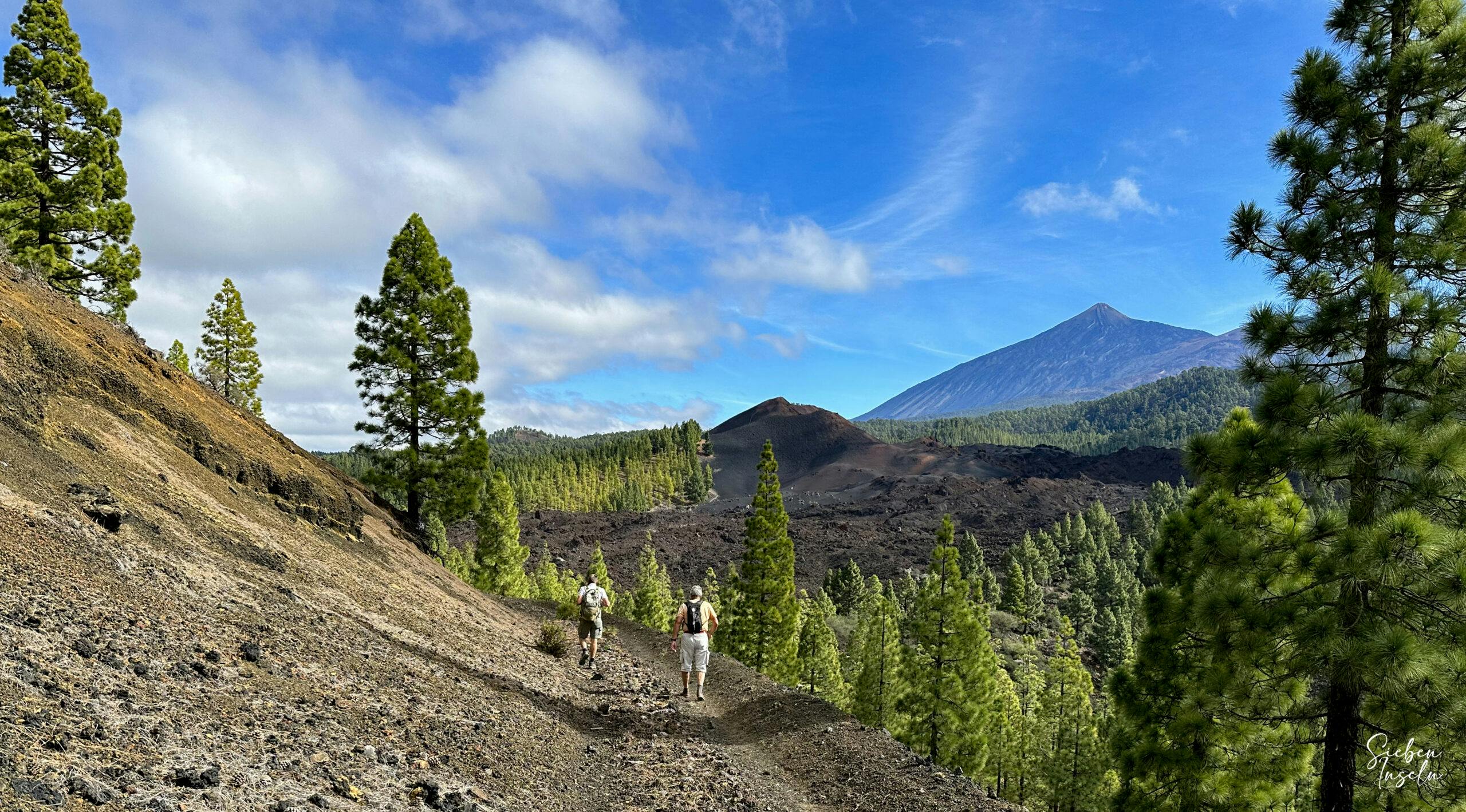
Hikers on the hiking trail in the forest towards the Chinyero volcano
After climbing gently up this path for a while, it joins a track. Follow this round to the left. After a short time, you will come to a large crossroads of tracks. The Pino Loro piste runs from left to right. Turn right and follow this track or the PR-TF 43.2 hiking trail straight ahead for a very long time. Eventually you will reach the pine forest on the track. Now continue on small hiking trails in serpentines up the slope of Montaña de los Tomillos towards Chinyero. Simply follow the main path PR-TF 43.2.
Montaña de los Tomillos section to the summit of Montaña de la Cruz
The hike is varied as it takes you from a village through a ravine and open terrain into the pine forest. You will come to a few forks, but simply follow the signposted PR-TF 43.2 towards Chinyero. At the end of the ascent path, you will come to a larger track. This is already the Chinyero circular route. You could go up to the Chinyero volcano on the left. Now, however, turn right and cross the upper lava field of the Chinyero volcano before Montaña de la Cruz. You will come to a point where PR-TF 43.2 merges into PR-TF 43.
Break on the Montaña de la Cruz
Here, a narrow path on the right-hand side of you, which shortly afterwards turns into a track, leads up to the Montaña de La Cruz. If you still feel like taking a short detour, you can either climb up the Montaña de la Cruz (1521 metres altitude) on short, steep paths or on the easy road. There is a small building at the top and you can enjoy truly magnificent views of the Teide, the Pico Viejo, the Chinyero and also the neighbouring islands of La Gomera and La Palma. The ascent is rewarded by the fantastic views and perhaps a rest stop.
Section from the summit of Montaña de la Cruz to Montaña Bilma
Back from the summit of Montaña de la Cruz, continue along the main PR-TF 43 trail. After a short time, the circular trail turns left up to Chinyero. However, you keep to the right downhill on PR-TF 43.3, which takes you down along the Montañas Negras (lava flow of the Chinyero) for quite some time. Then you come to a junction. Here you can see a small cave. The path to the left leads towards TF-38.
Hiking trail in front of Montaña Bilma over the lava flow of Chinyero
However, you walk straight down to the right towards Montaña Bilma and along the lava river. Further down, the path begins to cross the lava river. Immediately before Montaña Bilma, you reach the SL-TF 60 hiking trail, which leads left to Arguayo. Keep to the right. You are now on the famous Ruta de los Almendros, where you can admire the almond blossom in January and February. Below the Bilma, the path runs for a very long time across the lava field.
Hiking trail over a canal and lava fields down towards Valle Arriba via Calvario
Section from Montaña Bilma to Valle de Arriba
Finally, the lava path merges back into a track on the other side, which takes you round to the left after a short while to the small El Calvario memorial. This is where a priest is said to have stopped the lava flow of the Chinyero and thus saved Santiago del Teide. At the Calvario, leave the hiking trail and follow the road next to the memorial for quite a while. After a while, you can leave the track first to the right and later to the left onto a small hiking trail.
Old canal that runs over the lava river
The hiking trail shortens the large curve of the road and takes you very quickly and a little steeply down to Valle Arriba. If you prefer a more comfortable and longer route, you can also follow the road. At the end of the hiking trail at the Casas Altas in Valle de Arriba, turn right onto Calle San Fernando. Follow this road down to the left. At the end of the street, it joins the Camino Real and you are at the starting point of your hike.
Calvario memorial on the edge of the path
And finally
I hope you enjoyed this long but moderate and varied hike from Valle Arriba up to the volcanoes. I personally really enjoyed the variety and the fantastic views. It’s also nice that you can easily make it shorter or longer according to your wishes. I hope you enjoy your hike,
Dagmar from SiebenInseln
Thank you for reading!
If you've found my hiking guides on SiebenInseln helpful for your Canary Islands adventures, please consider leaving a small tip. Your support is greatly appreciated and helps cover the costs of maintaining this blog.