Los Carrizales a hidden little hamlet in the Teno Mountains
View of Los Carrizales Alto
Map
The hamlet of los Carrizales is a small village in the Teno Mountains not far from the famous village of Masca. Los Carrizales is a hamlet in the municipality of Buenavista del Norte, in the north of Tenerife. There are two parts of the village, Los Carrizales Bajo and Los Carrizales Alto – i.e. one lower down – and one higher up. Both districts are located at the upper end of the gorge of the same name at an altitude of up to 600 metres above sea level. Even though the Barranco of Los Carrizales is not as well known as the nearby Masca Gorge, it is always worth a hike because of its wild nature.
Slope path under a ruined house on first plateau to Los Carrizales Bajo
I have already described a hike from Los Carrizales via the well-known Abache Steig. The hike over the Abache trail starts at the same starting point as this hike. This time, however, you don’t hike up the mountain ridge to your left, but first descend a little into the gorge. You pass Los Carrizales Alto and Los Carrizales Bajo. On the way, you can visit a waterfall. People who do canyoning abseil down there. Normal hiking towards the sea is not possible at this point.
View during the ascent back to Los Carrizales
Hiking from Los Carrizales through lonely gorges and over the heights of the Teno Mountains
You hike across the entire gorge of Carrizales. On the other side, the trail climbs quite steeply up to the next ridge. From there you go down into the Barranco Taburco. And later, when you reach the next ridge, you go down again into the lonely Barranco los Barrancos. Finally, you go up and after a walk over another ridge and a last valley crossing, you finally reach the ridge between Teno Alto and the Mirador Baracán (Tabaiba Pass). And you can also find the hike up the Baracán on Seven Islands (link).
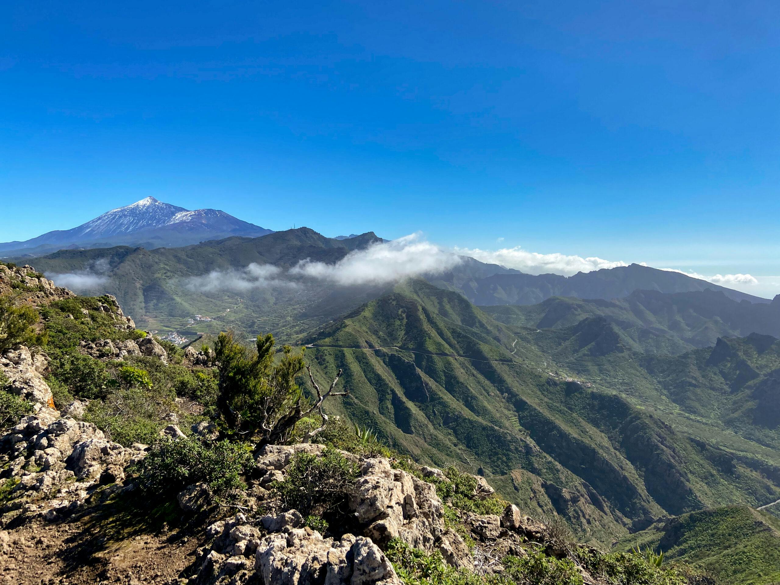
Teide and the Teno mountain ranges
You walk along the footpath on the ridge below the Baracán on the Camino de Baracán. And you can enjoy wonderful views over the Teno Mountains to the Teide and the coast. From the Mirador Baracán, the last part of the trail leads you back to Los Carrizales via the road towards Masca. A hike that offers wonderful views, but also takes you to lonely heights and into remote valleys of the Teno Mountains.
Los Carrizales Circular Hike Track
General information about the Los Carrizales circular hike
Starting point and access
The starting point is a small open space on the road to Los Carrizales (Calle Carrizal Alto). In the first bend after turning off the TF-436, you can park your car on the left-hand side. If the three or four parking spaces are already occupied, you can also park your car directly on the road or in Los Carrizales Alto.
Arrival by car
From the north, take the TF-436 from Buenavista del Norte, and from the south, take the TF-436 from Santiago del Teide. Take the car to the exit for Los Carrizales. After turning off, you will find the starting point of the hike in the first wide bend down into the village.
Getting there by bus
The Titsa bus line 355 runs between Santiago del Teide and Buenavista del Norte. If you get off at TF-436 at the entrance to Los Carrizales, you can easily walk the short distance to the starting point. For more information, see the Titsa homepage.
Time
I don’t like to give general times for hiking tours, because the times are very individual. We needed just under 5 hours for this hike, including an extensive rest. If you walk the extension over the ridge, you will need a little more time.
Elevation profile of the Los Carrizales hike
Article summary and large selection of GPS hiking tracks
Sign up for my newsletter now and get exclusive access to my collected GPS tracks as well as all the brief information about my articles.
There are approx. 730 metres of altitude difference to overcome on this tour. The route is just under 11 kilometres long. If you walk back over the ridge, it is almost 12 kilometres and 880 metres in altitude.
Altitude profile of the hike with return via the ridge
Requirements
For this hike you need to be in good physical condition, sure-footed and free from vertigo. Part of the hike is on good hiking trails (such as Camino de Baracán). However, some of the trails are narrow and difficult to find and go steeply downhill or uphill. This hike is certainly no walk in the park.
Refreshments
As far as I know, there are only restaurants and bars in Masca, a few kilometres away, or at Cruz de Hilda. Therefore, take enough water and food with you if necessary.
Track of the hike (red) with return via the ridge trail
Variants
This tour can be combined well with various other hikes and circular walks in the vicinity. Worth mentioning is the hike via the Abache trail as well as the hike via the Risco trail and Teno Alto. And the hike to Baracán is even a small part of the route of this hike.
On the way back, you have two options. You can choose the easy way back on the road or return to Los Carrizales with a few extra metres of altitude gain over the ridge.
View from the ridge path into Barranco Taburco
Great Circular Hike Los Carrizales
Route section car park via Los Carrizales Alto to waterfall
You start your circular walk at the first bend below the TF-436 above Los Carrizales Alto. The road down into the ravine quickly brings you to the hamlet of Los Carrizales Alto, through which you pass on the road. At the last houses on the right side of the village, a small footpath (marked yellow, white) turns off the road to the left. Follow this narrow path – which is sometimes quite overgrown at certain times of the year – steeply downhill over a small mountain saddle. As you do so, you will approach Los Carrizales Bajo, which is below you on the right. Eventually you will reach a wider track, which you follow downhill to the left.
At the Barranco Carrizales waterfall
When you are already below Los Carrizales Bajo, the road bends sharply to the right. There is an information board here and the way ahead is later for you on the road. But if you like, you can turn left off the path at this point and walk down a steep, narrow serpentine path to the waterfall. I was there some time ago. But on this last hike it had rained a lot beforehand and the narrow path was very slippery, so I didn’t quite make it to the waterfall this time. But it is quite impressive to watch canyoning at the waterfall. And so far, I have never encountered the waterfall without people setting out on the descent with wetsuits and ropes.
Hiking trail up the ridge above Los Carrizales
Waterfall section to ridge with summit cross
If you made the detour at a hiking sign to the waterfall, the trail then continues downhill on the wide road. You cross the Barranco Grund below Los Carrizales Bajo. Shortly afterwards, a small narrow path branches off from the wider path uphill to the right. From here, the path climbs quite steeply and in narrow serpentines. After the steep ascent, you will find yourself on a wide plateau, which you cross below a ruin. Once you reach the other side of the small mountain, the path goes downhill again for a short time. You cross a small barranco gully.
View of Los Carrizales back from the heights
Shortly afterwards, the really steep ascent begins on the ridge that encloses the Barranco Los Carrizales to the north. It is a long and steep climb on a very narrow path. But the path is not to be missed. Eventually you will reach a ridge on which there is a cross. With the hiking trail you come out just below the cross. From the ridge you have magnificent views over the Teno Mountains, to the Atlantic Ocean and back over Los Carrizales. If you keep following the ridge to the right, you should also come to the Camino de Baracán. However, I haven’t tried that yet, as we wanted to extend the round tour a little this time.
Article summary and large selection of GPS hiking tracks
Sign up for my newsletter now and get exclusive access to my collected GPS tracks as well as all the brief information about my articles.
on the ridge at the summit cross high above Los Carrizales
Route section from the summit cross to the Barranco de Barrancos
You descend on the opposite side of the ridge on a very narrow and steep path. You quickly lose altitude and end up in a small green valley. In January, many almond trees blossom there. The valley is already part of the Barranco Taburco. On the other side of the valley, you hike uphill again, cross a small ridge, and then descend again on the back side. Afterwards, you walk for some time above the Barranco Taburgo, keeping your altitude. Then you descend again along the slope to cross a lonely side gorge.
Rest on a mountain ridge - La Gomera in the background
Here you will also find impressive buildings built and caves into the rocks.
A steep climb follows on the other side of the gorge. You cross another ridge at the top, near which there is a threshing floor. Because of the impressive view, this is a wonderful place to rest. Afterwards, the hiking trail continues along the slope. At first it is only moderately uphill. But after the path turns to the right, it again goes steeply uphill for a short time onto a ridge. On the other side, below you, is the Barranco de Barrancos.
View of the Teide
Barranco de Barrancos to Camino de Baracán section
You now walk along the slope high above the Barranco de Barrancos. The last time I was there (February 2023), the entire Barranco was green with flowering trees and terraced fields. A pretty sight. Eventually, you reach the bottom of the upper part of the barranco. You walk a little upwards in the Barranco Grund. Then the trail climbs steeply on the right side of the slope to the ridge. Follow the ridge around to the left. The path bends slightly to the left around the gorge. You come to a wide track, which you follow for a short while on a wide left bend.
Hiking trail to the Barranco de Barrancos
Once you are back on the straight, a small hiking trail branches off sharply to the right. Now comes the most confusing part of the whole hike. On the ridge in front of you, you may already see hikers walking from Teno Alto to Mirador de Baracán. You continue straight uphill on the side of the slope. From time to time you can orientate yourself by cairns or just by footsteps on the ground. But the direction uphill is clear. It is quite a long climb. But then at some point you reach the Camino de Baracán hiking trail.
View from the heights of La Gomera and La Palma
Camino de Baracán to starting point via Los Carrizales Alto
On the hiking trail, keep to the right. Now all you have to do is follow the clearly visible trail, which always runs along the ridge, to the Mirador Baracán (Tabaiba Pass). I have described the hike on this path in the other direction to Teno Alto here. From the beautiful ridge path you have wonderful views over El Palmar in the north of the island and towards Carrizales and Masca in the other direction. You can see the Teide and the neighbouring islands of La Gomera and La Palma.
View of the Teide and the mountain ranges around Los Carrizales
If you like, you can also make a short excursion to the Baracán, which is almost 1000 metres high. A small path leads up below the summit on the left side of the main trail. Once you reach the Tabaiba Pass, you can either take the easy path to the right along the road to Los Carrizales or turn left a few metres along the road and take the signposted hiking trail towards Santiago del Teide. Here, however, you have to climb another 150 metres on the ridge. Then the hiking trail to Los Carrizales branches off steeply to the right and quickly brings you back down to the starting point. This is the end of a large hiking tour with several ascents and descents.
Hiking above the clouds - view from Camino de Baracán
And finally
I hope you enjoyed this big loop from Los Carrizales. It takes you to parts of the Teno Mountains that are not so well known. You can visit a waterfall, climb a peak and enjoy the beautiful nature in lonely canyons. Thank you for following Seven Islands and enjoy all your walks,
Dagmar from SiebenInseln
Thank you for reading!
If you've found my hiking guides on SiebenInseln helpful for your Canary Islands adventures, please consider leaving a small tip. Your support is greatly appreciated and helps cover the costs of maintaining this blog.
Thank you for your support!
SSL secured
Comments
Vlad - 07/05/25, 04:45 PM
Tackled this trail today, and it was quite challenging. With temperatures exceeding 32°C, the first 5 kilometers were tricky to navigate without a GPS track. The latter portion followed the official trail, which was well-marked and easier to follow. Thanks for sharing this route! Make sure to bring plenty of water—I had 1.5 liters, and it was barely sufficient in such heat.