For some time now, a prohibition sign has been posted at the beginning of the hike. There is a danger of walking on the path - the prohibition sign is drawn by the "neighbours of Masca".
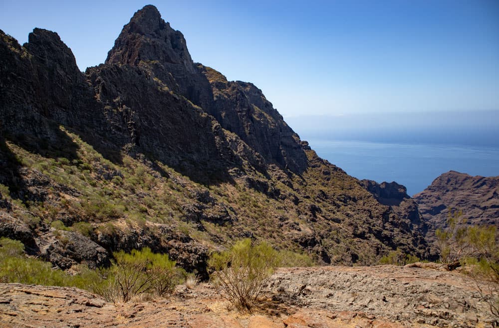
Fortaleza de Masca high above the Barranco of Masca
Panorama – Fortaleza de Masca
Map
The hike to Fortaleza de Masca is another fascinating climb in the Teno mountains. Tenerife is cut by deep Barrancos in rocky stretches of the coast, such as the Anaga and Teno mountains. Therefore there are naturally high rock walls between these gorges. And it is precisely on these ridges that you can make truly impressive hikes with unforgettable views.

Panorama - Fortaleza de Masca

view over Masca and the Barranco de Masca
Panorama – view over Masca and the Barranco of Masca
I had already written here on seven islands about the hikes on the Guergues Steig, the Abache Steig and the Risco Steig. Also the hike to Teno Alto past the Barancán is a climb hike that runs in large parts parallel to the Abache Steig. Today it is the last, but perhaps even the most interesting climb in the Teno Mountains. The Fortaleza de Masca, a truly impressive rock massif high above the Masca Gorge. 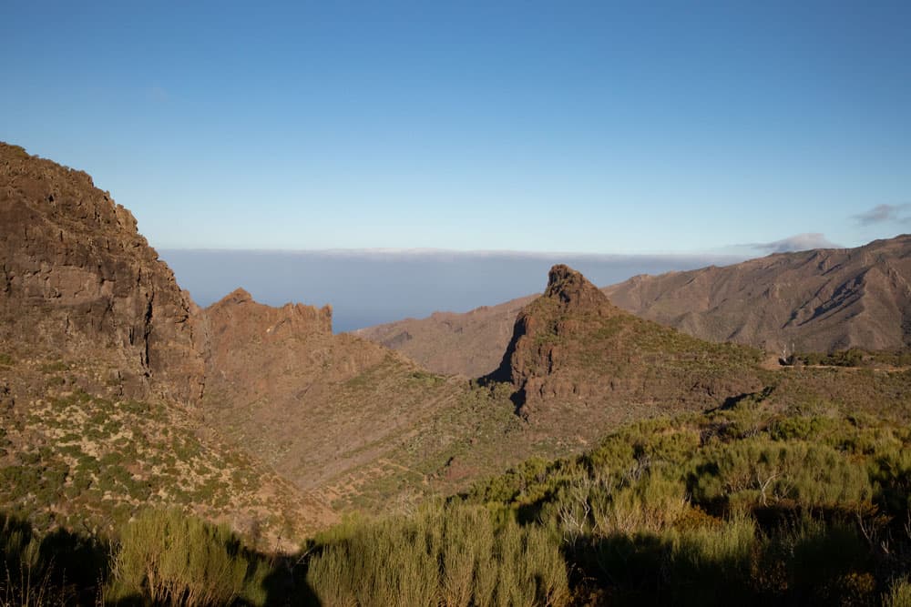
Fortaleza de Masca - view on the Abache Steig
Fortaleza de Masca – View to the Abache Steig
Each person perceives individual migrations differently. And there are still other factors that play a decisive role, such as the weather. On the same hike you can stand in clouds, fight against the wind and have almost no visibility. And another time you hike in the same place in sunshine, calm and a completely blue sky. However, I personally think that the Abache Steig is perhaps one of the shorter and easier ascents in the Teno Mountains. A sure-footedness and a head for heights are assumed. The hike to Fortaleza de Masca, however, is already much more demanding due to the partly very steep climbs.

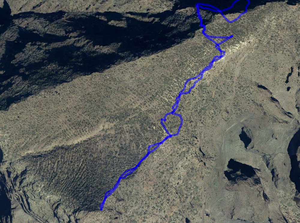
Track Fortaleza de Masca
General information about the climb Fortaleza de Masca
Starting point and approach
Starting point is the Mirador Cruz de Hilda high above the small village Masca at the TF-436. There are parking lots in front of the restaurant and at the side strip.
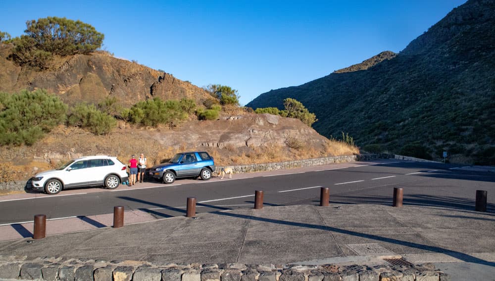
Starting Point - Cruz de Hilda
Arrival by car
From the north on the TF-436 from direction Buenavista del Norte and from the south on the TF-436 from direction Santiago del Teide you go by car to Cruz de Hilda.
Arrival by bus
The Titsa bus line 355 runs between Santiago del Teide and Buenavista del Norte. Further information can be found on the Titsa Homepage. Time
I don’t like to give general time information for hiking tours, because the times are very individual. For this hike I only needed a little more than two hours as pure hiking time. But on the way I was over 4 hours. This was also due to the fantastic views, which invited me to stop, rest and take a photo break.
Article summary and large selection of GPS hiking tracks
Sign up for my newsletter now and get exclusive access to my collected GPS tracks as well as all the brief information about my articles.
Sign up now
Track Fortaleza de Masca
Difference in altitude and distance
The pure difference in altitude of this hike on the Steig Fortaleza de Masca is only about 350 metres. But through some ups and downs, the total altitude difference is almost 500 metres. The distance that I hiked is a little more than 8 kilometres long. This is shown differently on the elevation profile. The reason is that my JPS did not consider the sometimes very steep ascents and descents. But I had other reliable data given to me by fellow hikers carrying a pure JPS device.
Requirement
In my opinion, this hike is of medium length and has some meters of altitude to offer even with steep ascents. The paths mostly lead close to the abyss. Therefore, absolute surefootedness and a head for heights are prerequisites. Please do not undertake this hike when it is wet or stormy. This of course applies to all hikes.
Refreshment
Restaurants, bars and shops are only available in nearby Masca or at the starting point Cruz de Hilda. Therefore, take enough water and food with you.

ridges in the Teno Mountains
Variants
This tour can be extended very well. Once you have reached the top of the Fortaleza de Masca mountain plateau, you can climb further in the middle of the ridge and to the other side of the mountain.
Extension of the hike up to the demolition edge
Extending the hike to the edge of the ridge
I walked down there and back up there. That’s about another 120 meters of altitude difference in the ascent and descent. It took me about an hour. As you can see on the track, there are some ways and possibilities. But the paths are very overgrown and sometimes hard to find. In the middle of the path there was a big open hole. So please be careful. You can climb up to the small elevation at the end of the ridge. So if you have enough condition for the inevitably following ascent, you can extend the hike very well at this point. The view from the hill is fantastic in all directions.
view on the Fortaleza de Masca
Ridge walk to Fortaleza de Masca
Cruz de Hilda section to Berggrat crosswalk
Fortaleza de Masca - junction street to road
You start your hike to Fortaleza de Masca at TF-436 at Mirador Cruz de Hilda high above the small village of Masca. From there it’s only a few metres towards Buenavista del Note and then a wide road leads you off to the left of the road. The entrance path is marked by a white yellow cross and is therefore easy to recognise. After a short time you will reach a small hill with antennas. From a kind of square, a small path leads straight on up the mountain.

view down to Cruz de Hilda
The path takes you up the hillside. You walk parallel to the TF-436, which quickly remains below you. Already here you have impressive views of the Cruz de Hilda and the village Masca. After some time you circle a rock ledge and change from the left to the right side of the slope.
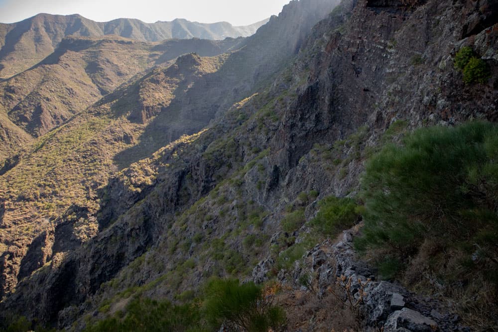
hiking path along the sloop
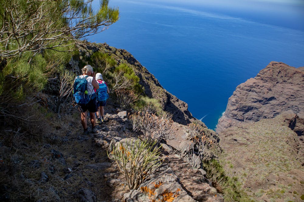
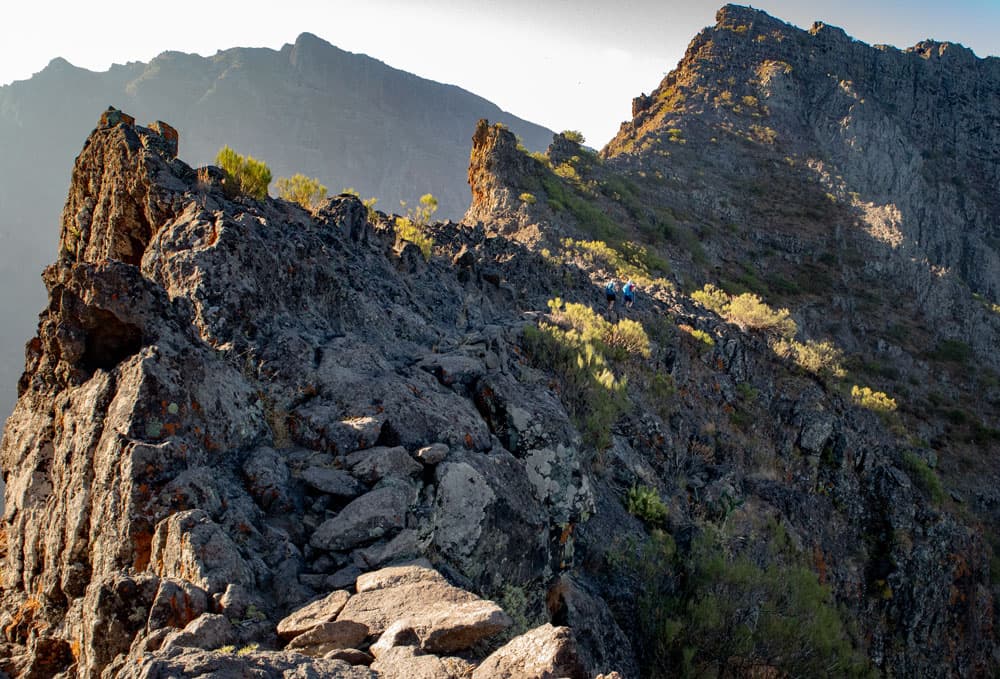
Fortaleza de Masca – ridge walk high above Masca
To get to the actual climb of the Fortaleza de Masca, you have to cross a path. First there is a small rock face on your left. Then the path leads you over a first rocky ridge, on both sides of which you can enjoy a fantastic view of the gorge on one side and Masca on the other.
Article summary and large selection of GPS hiking tracks
Sign up for my newsletter now and get exclusive access to my collected GPS tracks as well as all the brief information about my articles.
Sign up now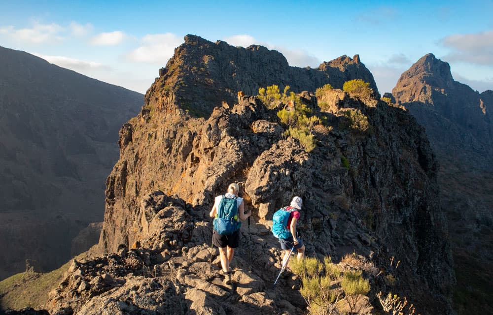
Fortaleza de Masca - ridge walk high above Masca
Section of the route Crossing the mountain ridge to below Fortaleza de Masca
The way over this first ridge then brings you down on the right side of the slope over stones and rocks. In front of you the mighty massif of Fortaleza de Masca appears. On the right side of the slope you walk down the mountain and move towards the rock face. The path takes you downhill in a wide arc until you walk parallel to the rock face.
on small stony pathways along the ridge and sloops
You can’t miss the path, because there is only this one path along the rock face. On the way there, it tends to ascend at first. But after a short time it mainly goes downhill for a while. You started at an altitude of about 850 meters. The climb brings you along the mountain wall parallel to the gorge then down to about 600 meters of altitude. There you will find yourself below the rocks of Fortaleza de Masca.

Fortaleza de Masca - steep rock wall
Section below the Fortaleza de Masca up to the plateau
From the deepest point of this hike the path now climbs steeply. Some of the paths are even buried by landslides. But all in all they are well doable. From time to time it goes uphill in very narrow steep rocky serpentines. At these places unfortunately also partly my JPS failed, which apparently meant that I did not move from the place. The reason is that in some places it really is almost steep. Therefore the hike – as you can easily see – is shorter in altitude profile than it actually is.
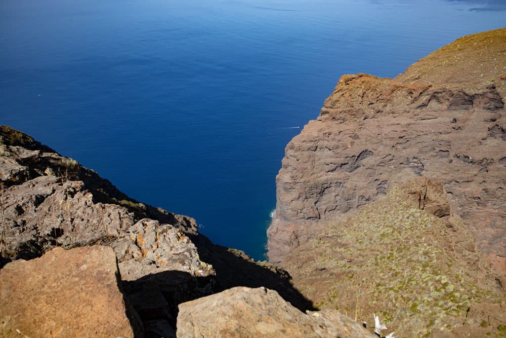
view from above to the North side to the Atlantik to the steep wall
But after this steep ascent, which takes you to an altitude of 750 metres, you will really be rewarded with a fantastic view. Already on the last meters before you reach the rock plateau, you can look down to the end of the gorge to the sea and the steep face. Then climb a few more meters to the left and you will find yourself on a plateau covered with bushes.

view down to the south to Masca bay
Route section plateau
On this plateau you now have many possibilities. I haven’t tried and explored everything there yet. First of all it is a good idea to cross the plateau on a clearly marked path. On the other side you are standing directly at the edge to the Barranco of Masca. From there you can look up into the Masca Gorge and down to Masca Beach. The Teide rises high above you. And far out in the Atlantic you can see the neighbouring islands La Gomera and La Palma.

view from the top to the little hill on the front ridge
From this point you can also climb further up to enjoy an even better view. I did that and was thrilled by the „overview“. But it went even higher. Maybe you’d like to climb even more in the direction of Fortaleza de Masca. How far it goes in this direction I haven’t tried yet.

Fortaleza de Masca - threshing circle
Afterwards we descended again and walked down the plateau. The paths are a little overgrown and not easy to walk. Many rocks and bushes have to be overcome. But in principle the way is feasible. Those who want to protect themselves from scratches of bushes should wear long trousers or even shirts. After a short descent you will pass an old threshing floor. So you can see that this trail was once used for agriculture. After some time my companions wanted to go back, so that we did not go further down.

view direction Guergues Steig and in the background Mount Teide
But I know from many other hikers that they have descended across the entire plateau. Down there you can climb the small elevation in front of it. Also from there there should be a fantastic view. Therefore I will certainly visit this point during my next visit on the Fortaleza de Masca.

stony path over the ridge
Since the way there is also the way back, you will easily find it.
And finally
I hope you enjoyed this further climb to Fortaleza de Masca. Of course I would be very happy if you would send me your ways and experiences on the Fortaleza as a supplement. Until the next time I wish you good and safe hiking at all times,
Dagmar von SiebenInseln