1/13/2020 (updated: 3/12/2026) | 17min Reading time
Great circular walk from Vera de Erques to the waterfall Cascada de Chindia
DifficultyHard
IslandTenerife
Altitude1100m - 1300m
Distance20km - 24km
Circular hike
Head for heights
In April 2023 there will be construction work on the waterfall, so there may no longer be a waterfall from the end of April. The circular walk is still possible and interesting.
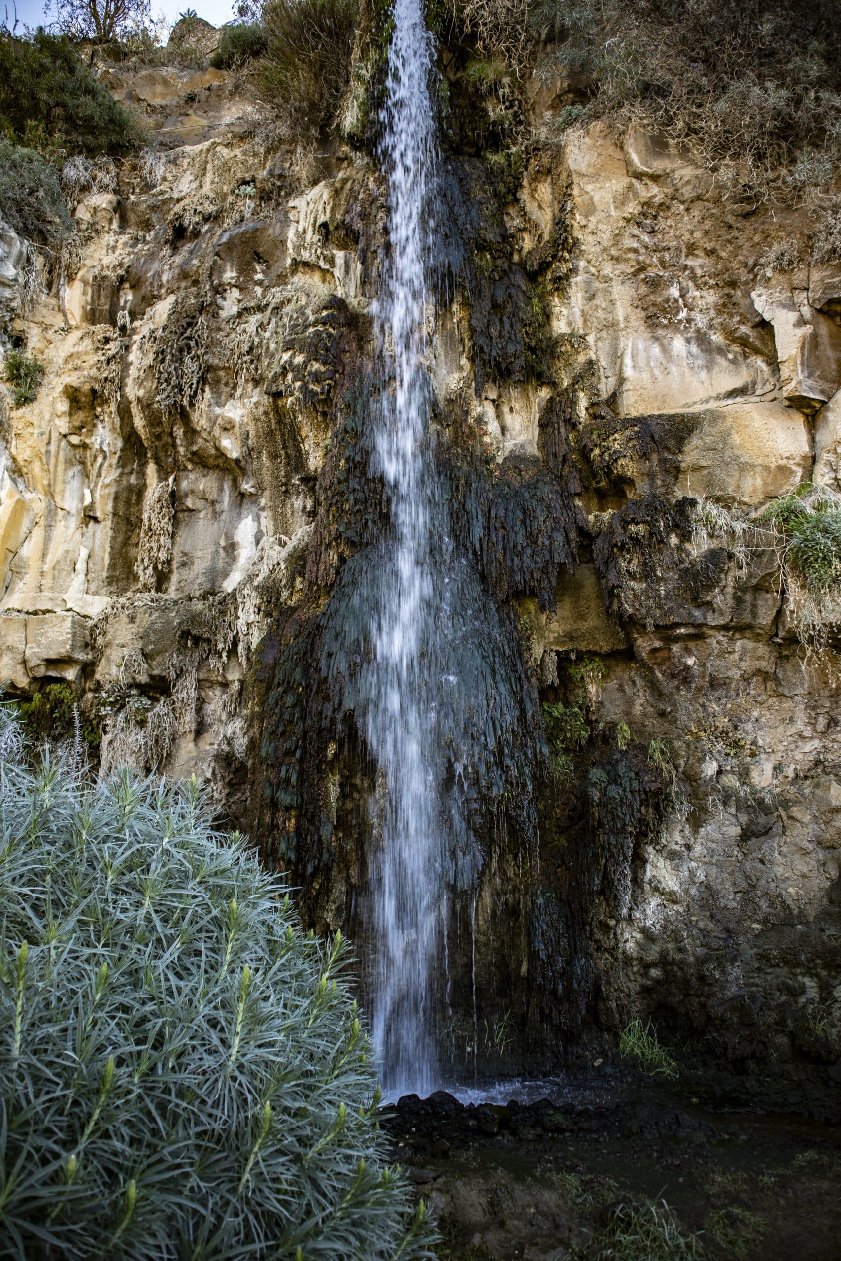
The waterfall Cascada de Chindia as the highlight of the hike
In Tenerife I have not seen so many waterfalls so far. I remember the Barranco de Infierno with its impressive waterfall and the Barranco Carrizales with waterfall. In some canyons, like in the Barranco de Masca there is often a lot of water and also small waterfalls at certain times after rain and snowfalls on the island.
The waterfall Cascada de Chindia
Map
But at a height of approximately 1.600 metres I have not found a waterfall on Tenerife yet. All the more I was glad to discover the Cascada de Chindia.
Abandoned Finca at the roadside
When friends of mine had discovered this beautiful waterfall and told me about it, I was very happy. And even more that we already made a hike there together. They had discovered the waterfall on a hike from Boca Tauce. Now we wanted to approach it from „below“, that is, from Vera Erques. The ascent is quite hard, as it is initially 800 meters of altitude – often quite steep – uphill. Arrived at the height, it is a little more moderate. After visiting the waterfall, we first go downhill. But before you arrive back at the starting point, there are some canyons to cross, among them the big Barranco de Erques.
Weather change at altitude - clouds coming up
Hiking, waterfall and weather
This hike is really a very special hike, which is probably not for everyone just because of the length and the many metres of altitude. As we tried out some small trails in the altitude, as you can easily see on the track, it can be safely reduced from 24 kilometres to 19 to 20 kilometres. But a good physical condition is still a prerequisite for this tour. But the waterfall Cascada de Chindia is a real speciality, so that for me the effort of the ascent was worthwhile.
Hiking trail along the water pipe
And then, of course, the weather plays a not inconsiderable role during the hiking. It can sometimes change faster than you can hike 😉 . On this tour it was shady and cloudy on the coast. But in Vera de Erques sunshine was waiting for us. With warmth and blue sky we hiked uphill. On the way back clouds came up, through which we walked in wet and foggy weather. Therefore it is worth to be prepared for all weather conditions on the „sunny island of Tenerife“.
Track of the hike from Vera de Erques to the waterfall and a small extension
General information about the circular hike Vera de Erques to the waterfall Cascada de Chindia
Vera de Erques - Place - Starting point of the hike
Starting point and approach
Starting point of this hike is the mountain village Vera de Erques (approx. 840 m altitude difference). The hike starts at the TF-465 (village centre, square, bus stop).
Approach by car
You come via TF-82 or the motorway (exit Vera de Erques) from the south or north of the island. Take the TF-465 above the motorway exit, which will take you in many hairpin bends up to the village of Vera de Erques. Sufficient parking spaces are available on the square and at the roadside in Vera de Erques.
Approach by bus
The Titsa bus lines 417 and 490 stop in Vera de Erques. End stop is also the starting point of the hike. You can find more details on the Titsa Homepage.
Time
I don’t like to give general time indications for hiking tours, as the times are very individual. We needed more than 6 hours for this tour with extensive rest, visit of the waterfall and small extra ways. Without the small deviations you should surely calculate with at least 5 hours.
Article summary and large selection of GPS hiking tracks
Sign up for my newsletter now and get exclusive access to my collected GPS tracks as well as all the brief information about my articles.
Altitude profile of the hike Vera de Erques to the waterfall
Difference in altitude and distance
The pure height difference is about 800 meters. But with the up and down and Barranco crossings on the way back you will reach almost 1,300 meters (after deducting the detours you will probably be able to reduce it to 1,100 meters). Our route was about 24 kilometers long with the small detours. The round trip alone should be about 19/20 kilometres.
Requirement
This is really a tour that is not suitable for everyone because of the many meters of altitude difference and the length and definitely requires a good physical condition.
Refreshment
Restaurants, bars and shops are only available in Vera de Erques. Therefore, take enough water and if necessary food with you.
Track hike from Vera de Erques to the waterfall and adjacent track of a hike from La Quinta
Variations
This tour is – as you can see on the track – provided with little „off-roads“ which you can leave out. We wanted to try out if there are ways back to the way back from these outsourced points. Unfortunately we did not succeed in finding a suitable way. Therefore the JPS track has been changed accordingly. So if you want to take the pure round trip – watch out. You can also shorten the way if you only go from Vera Erques to the waterfall and back the same way.
The Cascada de Chindia waterfall can also be reached from Boca Tauce on a great circular hike. You can find the complete tour description here.
You can combine this tour with many tours in the surroundings of Vera de Erques. Mentioned here are only the tours at the Barranco de Erques and the circular hike around Tijoco Alto.
View from the hiking trail back to Vera de Erques
Round walk Vera de Erques – Waterfall Cascada de Chindia
Section Vera de Erques to abandoned big house at the roadside
You start your hike at the TF-465 in the centre of Vera de Erques. From there, turn right down Calle la Parranda, cross a small gorge and then walk up the road. After a short time, the main road continues straight ahead. You turn left onto a small road that goes steeply uphill. After that you follow this road, which turns into a road and field path, straight ahead for a long time. You will pass some farms and finally you will come out of Vera de Erques.
Hiking trail to the waterfall above Vera de Erques
For the first 4 kilometres of this hike, you will climb up towards Cañadas for about 800 metres to reach the Cascada de Chindia waterfall. After some time of climbing, you cross a small gorge to the left and continue climbing on the next ridge. Do the same thing again after some more time. The path is easy to see and is often marked out with stones along the sides. Finally, high above you, you will see a large abandoned house in the distance. You continue to climb up the path and finally pass this house.
View towards the Teno Mountains on the way to the waterfall
Part of the trail: large abandoned house to the waterfall Cascada de Chindia
When you have passed the house, keep going straight ahead on the hiking trail uphill. The path always leads up the ridge. From time to time paths to the left and right cross your way. But you keep going straight ahead. On the left side, in the side gorge, there is another small house with developed caves, which you pass. Slowly the pine forest begins. Now it won’t take long and you’ll come to a wide driveway, which you follow to the right. Now you have reached the highest point of the hike.
Hikers on the hiking trail to the waterfall
From here you follow the wide path in wide serpentines along the edge of the pine forest. If the weather is fine, you will have magnificent views of the coast and at the same time up to the foothills of the Cañadas. After some time you will already see a wide gorge from a distance. In front of you on the right side of the gorge you can see the waterfall Cascada de Chindia. A path branches off to the left from the path and in a short time it will take you directly to the waterfall.
Article summary and large selection of GPS hiking tracks
Sign up for my newsletter now and get exclusive access to my collected GPS tracks as well as all the brief information about my articles.
Section of the Cascada de Chindia waterfall to canal path
At the waterfall itself you can take a break or a picnic. Maybe you would like to refresh yourself a little in the water. Afterwards you go back to the path, which you now follow further to the left. Now and then it goes uphill again. The path winds up and down through pine forest over gorges. After some time you will come to a fork. As you can see on the track, we have continued straight on for quite a while and then made some attempts to find a long way back downhill to the right. You can do that – but you don’t have to do it.
Hiker in front of the waterfall
The round trip leads you downhill on a track on the right at the fork in the road. You walk straight for quite a while and then also downhill in a few turns. We came into the clouds at this point, so I did not see much of the landscape. You ignore branching paths until you come to a fork in the road. Now you follow the road for a short time down to the right through a small canyon. On the other side of the gorge you will find a canal that crosses the road. Follow the small path to the left, which always runs along the canal.
Hiking trail along the pine forest
Section of canal path to abandoned house
The next section of the trail is also part of the hike around Tijoco Alto and touches sections of the hike at the Barranco de Erques. You walk down the narrow path for quite a while on the right side of the canal. Finally you cross the water channel to the left and continue walking downhill through the pine forest. Then you will meet a large driveway on the left side. On your right is a square with many chairs. Hunters often meet there. Follow the driveway to the right downhill.
View of the mountains near the Cañadas with pine forest
After a while a wide path branches off to the right through the forest downhill. Follow it. In a nice curve with good views of the coast and the Teno Mountains, a well laid out path takes you further down along the ridge. After some time you will pass another abandoned house. There the hiking trail Tijoco Alto leads along. But now you stay on the path that leads you in wide serpentines down through the forest.
Women hikers on the trail near the waterfall
Section of the trail: abandoned house to the ridge path Barranco de Erques
The path takes you down a slope and ends on a long straight line in a barranco. You follow a driveway to the left, which will lead you around a barrier to a road after a short time. You follow the small road downhill to the right for a short time. Then you will come to a big building on the right side. Turn right off the road and walk around the building. For a short time the path will take you in an arc through a little forest. And then you are standing at the edge of a barranco. This is the Barranco del Agua. You follow the path along the Barranco edge and can already have a look into the Barranco and the opposite side of the gorge.
Hike Vera de Erques to the waterfall - rock formation
After a short time the main path continues straight ahead. But you turn right on a path down into the Barranco del Agua. Actually, this is only a small spur of the big Barranco del Agua. As in a short time, you are already on the Barranco ground that you cross. At the other side, the path leads you again in a steep ascend uphill. Then you are on the ridge between the Barranco del Agua and the big Barranco de Erques. From here, you can already have a view into the Barranco ground that is deep in front of you.
Hiking in the Barranco de Erques
Section Barranco de Erques to Vera de Erques
You walk straight downhill on the ridge path for a very long time. The path then leads you from the top of the ridge down the slope on the right and ever closer to the actual edge of the Barranco de Erques. If you are then standing directly at the edge of the ridge, you have a fantastic view from the height into the depth of the gorge. Once again, one passes an abandoned house. And then the descent into the deep Barranco follows. At first long straight paths lead into the depth. Just before the bottom there are narrow steep serpentines.
Barranco Ground Erques - Women hikers on the way
You cross the Barranco bottom and climb up again on the opposite side. After a long straight line high above the Barranco bottom you finally reach a road, the TF-465, in Vera de Erques. Follow this road for a short distance to the left and then turn right at the first opportunity onto a small path. This will bring you back on the road after a short time. But this way you have shortened a long curve. Now you have to go a little further to the right on the TF-465, which will take you back to the starting point of the hike.
the Barranco with the waterfall (visible in the middle of the picture in the distance)
And finally
I hope you enjoyed this great hike around Vera de Erques to the waterfall Cascada de Chindia and through the Barranco de Erques. If you know any other waterfalls in Tenerife, I would be happy to receive hints or a comment from you. If the total distance of the hike is too long for you, you can also experience the Barranco de Erques and the waterfall in shorter single tours. Whatever you decide to do, I wish you much fun on all your hikes,
Dagmar from SiebenInseln
Thank you for reading!
If you've found my hiking guides on SiebenInseln helpful for your Canary Islands adventures, please consider leaving a small tip. Your support is greatly appreciated and helps cover the costs of maintaining this blog.