Barranco Juan López between Masca and Los Carrizales
The Barranco Juan López is located in the south-western part of the Teno Mountains. It is dominated by gorges that run down to the sea, so you will always find a gorge, a ridge and another gorge. The large gorges all run from the heights down to the sea.
Map
View into the Barranco Juan López
There, together with the ridges from the sea side or from Los Gigantes, they appear to us as one steep wall. In fact, they are precisely not. This gives hikers in this part of the Teno Mountains the wonderful opportunity either to walk along the many ridges or to hike into the gorges.
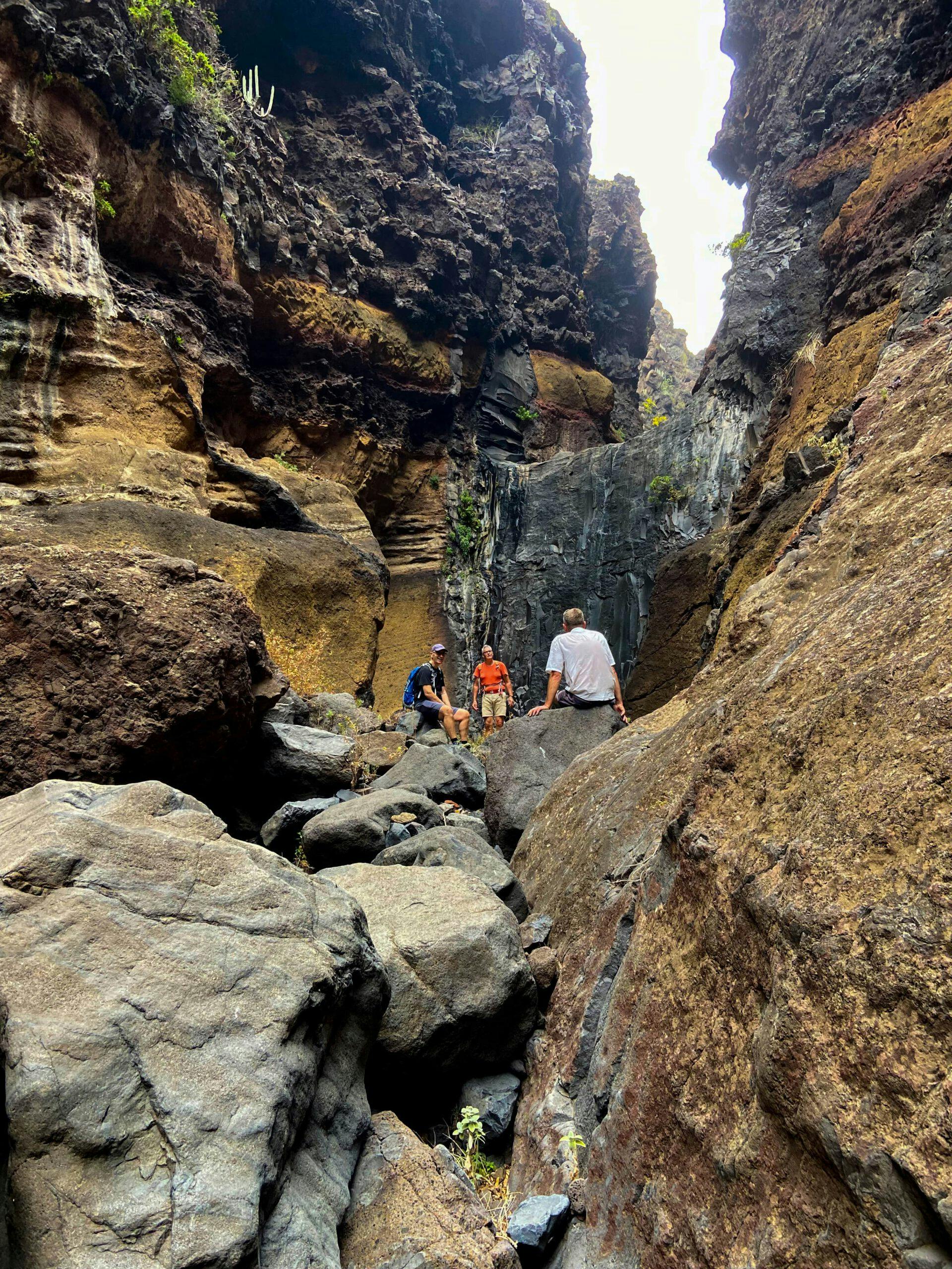
Colourful rocks, where the Barranco Juan López and the Barranco Retamar meet
A little adventure – Barranco Juan López
But if you are in good shape and like to scramble a little, this is the right barranco for you. The upper part is still green, wide and full of terraced fields, while the lower part is more rugged, steep and impassable. Nevertheless, there is a path that not only leads you down to the sea, but also into the side gorge Barranco Retamar. You are unlikely to find any other hikers on these rough stretches.
Barranco Juan López
You start the hike from the Abache path or alternatively directly at the TF-436 or from the Cruz de Hilda. At first, you go downhill on narrow paths through the wide upper green part of the gorge. Later, it narrows. At a certain point, the path goes steeply downhill on the left side of the slope, along impassable paths. You walk along a band of rocks with impressive colours. The last stretch to the sea (about an hour) you have to climb exclusively over large stones in the Barranco Grund to reach the sea. An adventure and definitely not suitable for everyone.
Track der Wanderung in den Barranco Juan López
General information about the hike in the Barranco Juan López
Starting point and approach
The starting point is a small square on the road to Los Carrizales (Calle Carrizales Altos). In the first bend after turning off the TF-436 you can park your car on the left. This is also where the hike starts.
Article summary and large selection of GPS hiking tracks
Sign up for my newsletter now and get exclusive access to my collected GPS tracks as well as all the brief information about my articles.
From the north, take the TF-436 from Buenavista del Norte, and from the south, take the TF-436 from Santiago del Teide. Then drive your car to the exit for the village of Los Carrizales. The starting point of the hike is already in the first wide bend down into the village.
Getting there by bus
The Titsa bus line 355 runs between Santiago del Teide and Buenavista del Norte. If you get off at TF-436 at the entrance to Los Carrizales, you can easily walk the short distance to the starting point. For more information, see the Titsa homepage.
Time
I don’t like to give general times for walking tours, as times are very individual. It took us 6.5 hours, including a long rest on the beach.
Höhenprofil der Wanderung in den Barranco Juan López
Difference in altitude and distance
The difference in altitude is more than 950 metres. This is due to the many small ascents and descents and the constant climbing over large stones and rocks. The route is a little less than 13 kilometres long with the branch into the Barranco Retamar.
Requirement
A difficult hike with many small „climbs“ for which you need a very good physical condition as well as absolute freedom from vertigo and surefootedness.
Refreshments
There are no restaurants, bars or shops anywhere on the tour. Therefore, be sure to take enough water and, if necessary, food with you.
You start your hike just below the TF-436 road that connects Buenavista del Norte and Santiago del Teide. The starting point is on the road to Carrizales Altos at the first bend. From there, a partially cemented road leads you briefly downhill. The actual hiking trail begins below, which takes you uphill in a curve to the right along the slope. You go up the right side of the slope on a well laid out hiking trail. After a while, the trail continues on the right side of the slope on the Abache Steig. But you go around to the left on a short steep path up to the ridge. From up there you have a first really good view of the Barranco de Carrizales on one side and the Fortaleza de Masca on the other.
Hikers on the entry path at the Barranco Juan López ruin
Up here there are fenced-in private plots. Walk past them on a small path on the left. The path takes you downhill on the other side of the slope towards the Barranco Juan López. Up here, the Barranco is still wide and green and full of terraced fields. You will reach a small road, which you follow to the left for a short time. Incidentally, you can also get to this track from the TF-436 or from Cruz Hilda. So there are two alternative entrances to this hike. But at this point you leave the road on the right side on a small path. This path, which is somewhat overgrown in places, takes you past ruined houses across the bottom of the Barranco Juan López.
Hikers in the upper part of the Barranco Juan López
Route section Ruined houses to coloured band Rock face
Once you have walked along the path over the bottom of the barranco, you will climb up again on the other side of the slope. You walk along the side of the slope towards the sea, gaining quite a bit of altitude. Eventually you will reach a ridge with good views to the left into the Barranco Retamar and to the right into the Barranco Juan López. On the ridge, keep to the right for a short while. Here it becomes a bit difficult to find the way. You are in front of an elevation on the ridge. The path leads relatively steeply downhill on the right side of the slope.
Hikers at the Barranco Juan López rock band
You walk downhill for quite a while on the path above the barranco on the left side of the slope. On your right you can already see into the deep gorge. Finally, at the end of a ridge, you reach a place marked with stones on both sides. You step through here as if through a gate. From here the more difficult part of the hike begins. From now on, the path, which is often difficult to find, takes you steeply downhill between bushes and stones into the Barranco Juan López. Very slowly, you walk along the steep rock face deeper and deeper into the barranco. Finally, you reach a kind of very distinctive coloured band on the rock face.
at the Barranco Juan López rocky band
Barranco Retamar break-off edge with abseil hooks
Section of the ribbon of rock to Barranco Juan López beach
You hike steeply downhill along the yellow and reddish shining rock of the coloured band until you reach the bottom of the Barranco Juan López. Here you can make a small detour to the left and hike and scramble a little into the Barranco Retamar. It is worth the effort. The barranco is narrow here and full of large colourful stones. The exploration ends at a large smooth rock wall. To get up here, a rope would be needed. At the top of the wall, you can see a rappelling hook. This is where you come out on a rappelling tour through the Barranco Retarmar. I did this once, and it took quite a long time because there were many hidden rappelling points. But this is a hiking website, so I’ll leave my rappelling tours out of it.
In the lower part of the Barranco Juan López, you walk over many large rocks
Now go back to the place where the Barranco Retamar leads into the Barranco Juan López. It is now three quarters of an hour to an hour to the beach, depending on your pace. But it’s not without its difficulties, because you have to keep climbing over large stones. This can be fun, but it is also exhausting. There is no path. However, the narrow barranco leads you in the direction of the sea. And then you’ve done it. You are actually on the beach of the Barranco Juan López. It’s worth taking a break here, because the way back along the same path takes you steeply uphill all the way.
on the beach of the Barranco Juan López
And finally
I hope you enjoyed this hike into the lonely and impassable Barranco Juan López. It really does require a good level of fitness, surefootedness and a head for heights. If this is not for you, there are many beautiful and much easier hikes in the immediate vicinity. I wish you much joy on all your hikes,
Dagmar from SiebenInseln
Thank you for reading!
If you've found my hiking guides on SiebenInseln helpful for your Canary Islands adventures, please consider leaving a small tip. Your support is greatly appreciated and helps cover the costs of maintaining this blog.
Thank you for your support!
SSL secured
Comments
Raoul - 03/17/23, 10:54 PM
Long trousers would be nice to wear. I did it 14 march 2023 and the path was overgrown by plants. On the steep part I fell and hurt my foot and wrecked my trailshoe. Pushed forward to the beach. The sound of rolling stones. Nice! Took a ‘bath’ by sitting on my but and was almost pulled back in to the sea. Time to go back. I made the route by afstandsmeten.nl and later I saw this site. Nice!
Dagmar - 03/18/23, 08:19 AM
Thank you for your experience report. I was there again recently. Due to all the rain during the last month, many of the paths are overgrown, but it’s still a great tour.
DaveDia - 03/20/23, 09:27 PM
Hi! Very nice review and photos! I will be on the island soon and would really like try this one (even though it would be probably a little too much for my friends…).
I will be able to spend only one (maybe 2) day near Masca, what do you think is the best trail in the area? The one to the Fortaleza de Masca (and even further) seems very interesting too!
Do you think these are viable alternatives compared to the much more famous “Barranco de Masca”? I will be on Tenerife during the weekdays only, do you think I could try to hike this one anyway (even though it’s officially open only during the weekends)?
Thank you very much
Dagmar - 03/20/23, 10:46 PM
Hi, Masca you can do only at the weekends, but Fortaleza de Masca or Abache Steig or Barranco Juan Lopez or close and offer fantastic hikes. Enjoy
Edmunds - 10/15/23, 03:30 PM
Compared to this, Barranco de Masca is like walking the Los Cristianos promenade while sipping Starbucks.
Edmunds - 10/15/23, 03:29 PM
Just did this walk today, and wow, what an amazing place, amazing hike.
There is a faint, overgrown trail at the beginning, then it thins out and is more like a route. Once you are at the bottom of the canyon, there is no trail, you are just climbing over boulders. Definitely not your every day walk in the park, but if you are looking for something more interesting, more challenging, then this is something. Route finding is not very hard as the canyon is pretty narrow and it is rather obvious where you are going, there is not a lot of space to make mistakes.
The walk stats at the top are almost certainly wrong. It took me 5 hours (with photo and food stops), elevation gain 790m, total length 11.5km, this includes the detour into Barranco Retamar until the wall.
Dagmar - 10/15/23, 05:38 PM
Edmunds – the stats are not wrong – we did it in this way, but of course every walker and every walk are different
Edmunds - 10/29/23, 09:44 PM
Well, the highest point in this walk is only 680m above sea level, so 1300m altitude gain is unlikely, and it is probably just GPS malfunctioning in the narrow gorge. Considering a few ups and downs, the 790m total altitude gain my watch gave me seems appropriate.